Dihar (archaeological site)

Last updated
Dihar
West Bengal relief map.svg
Archaeological site icon (red).svg
Shown within West Bengal
Location Dihar, West Bengal, India
Coordinates 23°07′10″N87°22′00″E / 23.11944°N 87.36667°E / 23.11944; 87.36667 [1]
TypeSettlement
History
Founded2700 BCE [2]
Abandoned Medieval/Late Medieval (Malla)
Cultures Neolithic and Early village farming culture [3]
Eventsnot known
Site notes
Excavation dates1983–84, 1984–85, 1993–94, 2008–09 and 2012–13
ConditionRuined
OwnershipPublic
Public accessYes

Dihar is an archaeological site of Neolithic and Early village farming culture located in the Indian state of West Bengal. Construction of the settlement is believed to have started around 2700 BC. [2] Dihar people developed a system of exploitation of natural resources and subsequent commercialization of commodities (prehistoric exchange system). The financial security afforded by this system encouraged artistic excellence in pottery making (which surely entails an appreciation of created forms) and bone-working. [4]

Contents

The prehistoric settlement at Dihar village was discovered in 1983 by the University of Calcutta's Department of Archaeology. [5] Excavations at Dihar were carried out in two phase, the first phase was conducted in 1983–84, 1984–85 and 1993–94 [5] and the second phase in 2008–09 and 2012–13. [6]

Bowls, black-red pottery and miniature vessels were discovered during the excavations. Human skeletal remains have also been found in the excavations. [7]

History

In the early period (pre-metal phase) the people of Dihar were involved with agriculture. At this time they did not know the use of metals. They mainly used various tools made from stone. Animal husbandry existed alongside food production through agriculture. This change was achieved after the abandonment of the subsistence technique of prolonged hunting-gathering. [4]

It is estimated that they started using metal around 1500 BC. Evidence of the use of metal has been found in Dihar as early as 1300 BC. [4]

During the early historic period population and settlement characteristics, including area, increased rapidly. Apparently, settlement shifted along a north-south axis about 1000 BCE. [8]

By the end of Malla period (10th to 17th centuries AD) the settlement had spread beyond their earlier boundaries, and developed into an emerging politico-religious consciousness. Two Shiva temples of Dihar were built on top of the structural mounds or remains of the earlier settlement to legitimise of the relationship between the ruling authority and the ruled. [8]

Chronology

According to the samples obtained, the Dihar period is divided into six cultural phases. Use of metals was absent in the first phase, but use of metals began in the second phase; in two phases, the Early Agricultural Culture and the Black-Red Pottery Culture developed. The third phase belonged to the early historic period. The Black-Red Pottery culture was present during this phase. The fourth phase belonged to the Early Indian Middle Ages. The fifth and sixth phases included the pre-Malla and the Malla period of the medieval respectively. [3] [9]

StagesDatesEvents
Stage I2700–1500 BCE Early Agricultural Culture and Black-Red Pottery Culture
Stage II1500–500 BCE Early Agricultural Culture and Black-Red Pottery Culture
Stage IIIearly historic period
Stage IVIndian Middle Ages
Stage V10th to 17th centuries ADpre-Malla period
Stage VIMalla period

Archaeology

Four mounds have been standing in Dihar village since ancient times. The villagers were aware of the presence of mounds. Except the Hirapur mound, the remaining three mounds have temple. [10] Later the University of Calcutta undertook a program of survey exploration and excavation. This settlement was discovered while exploring the mounds. Dihar was first excavated in 1984 and last in 2013, which extending Bengal's early village farming culture to 2700 BC. [2] The site is located 6 kilometers (3.7 mi) from Bishnupur, the capital of the medieval Mallabhum kingdom, on the north bank of the Dwarakeswar river. [1] [11]

Archaeologists claim that the settlement was a center of early village farming culture and the Black and red ware culture of West Bengal. [9] According to the carbon 14 dating of samples from the Hirapur mound, Dihar is the oldest archaeological settlement of the early village farming culture discovered in modern West Bengal. Among the four mounds at Dihar, the oldest specimen is from the Hirapur mound, which is 4700 years old. [2] Early village farming culture in Dihar existed between 2700 BC and 1500 BC, [2] [9] which was contemporary with the Pre-Harappan, Harappan and Post-Harappan periods.

Civilization

The people of Dihar contributed in settlement, metallurgy and pottery to the civilization of Bengal and Lower Gangetic Valley. They also contributed to jewelery making; in the early period jewelery was made from bone and later from metal.

Metallurgy and jewellery

The people of Dihar first started using copper, and later iron. The plateau environment, and the forest dwellers and ancient metalworking traditions in the forest region must have influenced and dictated the situation at Dihar. The Chota Nagpur plateau served as a potential metal source. Workers made rings and rods from copper. Perhaps these sticks were used for applying eye collyrium. [12]

A broken specimen was recovered from Mansatala Mound. It was probably identified as a tool used for gathering aquatic plants or for bush clearance. This eroded specimen has a considerable thickness with 5.6 cm. According to the weight and shape, it suggests to be classified as a "heavy-duty" tool. Only a skilled metalworker would be able to make such an elaborate tool, which making Dihar's metalworkers demonstrative of skilled craftsmanship. [13]

Art

Terracotta beads, various toys, discs and animal figurines have been found at Dihar. An unidentified animal figure of red color was found with two legs in a diagonal position at the back of the body. A few more fragmentary parts of animal figurines have been excavated. All these figurines bears witness to the technical skill of the Dihar's artists. All the excavated fragments are red in colour. Fragments of a human figure, red in color, were found. [14]

Dihar artists painted designs on red and black colored pottery. Both white and cream colors have been used. It was customary to fill the entire interior of ceramic dishes with two diagonally running designs with rows of straight and slanted parallel strokes painted in white. The exterior surface close to the rim is encircled by a band of petal-like motifs surmounted by a row of parallel strokes. In most cases the decorative elements were applied near the neck of the vessels and below the border line from where the slope towards the base begins. The ceramic art of Dihar is comparable to the Ganges Valley archaeological sites such as the Raja Nal Mound (Raja Nal Ka Tila), Malhar, Lahuradewa, Jhusi, Narhan, Agiabir and Senuwar. [15]

Cultivation and Diet

Excavated mounds have revealed the existence of an early rural agricultural culture, which gives an indication of cultivation by the inhabitants of the settlement. [2] The bones of many animals including domestic and wild, indicate a wide food culture. [16] In addition, bone tools, arrowheads and spears provide evidence of the hunter-gatherer lifestyle of the inhabitants. [17]

Excavated Dihar

The archaeological site was discovered by excavating four mounds at Dehar village, namely Maa Bhavanitala Dhibi, Hirapur Dhibi, Mansatala Dhibi and Kalbhairavatala Dhibi. [1] The Maa Bhavanitala Dhibi (mound) is spread over 300 square meters. [18]

Cut and worked bones

Cut bone and bone tools, arrowheads, and spears have been found. [19] Industrial or manufacturing workshops (potters and metal workers) and furnaces are visible on the Mansatala mound. [17] [19] [20]

Human skeleton

An almost completely preserved human skeleton has been excavated from the Manasatala mound, [7] which provides very good information about the age, sex and disease. The human skeleton was studied in November 2013, which probably belongs to the early historic period. [21] According to the test results, the skeleton was that of a male, and was around 45 to 50 years old. [22] On observation, lesions in teeth and bones, and pathological lesions were observed. Unfortunately the skeleton does not help to understand the population. [23]

Pottery

Evidence of pottery begins from Period I. Black and red pottery, carinated vessels, basins, tumblers and miniature pots give evidence of ceramic industry. [24] [25]

Wattle and daub structures

Reed impressed clay have been found, which reflecting widespread use of Wattle and daub structures. Presumably, the structures were originally used for construction of house. According to the results obtained from sample tests, Wattle and daub structures were built during the Pre-Metallic and Metallic early village farming culture. The tradition of building such structures to have continued for a much longer period. In excavation, mud or rammed floor and reed impressed chunks were found. [26]

Related Research Articles

<span class="mw-page-title-main">Mehrgarh</span> Neolithic archaeological site in Balochistan and Pakistan

Mehrgarh is a Neolithic archaeological site situated on the Kacchi Plain of Balochistan in Pakistan. It is located near the Bolan Pass, to the west of the Indus River and between the modern-day Pakistani cities of Quetta, Kalat and Sibi. The site was discovered in 1974 by the French Archaeological Mission led by the French archaeologists Jean-François Jarrige and his wife, Catherine Jarrige. Mehrgarh was excavated continuously between 1974 and 1986, and again from 1997 to 2000. Archaeological material has been found in six mounds, and about 32,000 artifacts have been collected from the site. The earliest settlement at Mehrgarh—located in the northeast corner of the 495-acre (2.00 km2) site—was a small farming village dated between 7000 BCE and 5500 BCE.

<span class="mw-page-title-main">Tell Tayinat</span> Archaeological site on the Orontes river in Hatay Province, Turkey

Tell Ta'yinat is a low-lying ancient tell on the east bank at the bend of the Orontes River where it flows through the Amuq valley, in the Hatay province of southeastern Turkey about 25 kilometers south east of Antakya, and lies near Tell Atchana, the site of the ancient city of Alalakh. Tell Ta'yinat has been proposed as the site of Alalaḫu, inhabited in late 3rd millennium BC, mentioned in Ebla's Palace G archive; and in later times as Kinalua, the capital city of an Iron Age Neo-Hittite kingdom.

<span class="mw-page-title-main">Painted Grey Ware culture</span> North Indian Iron Age culture

The Painted Grey Ware culture (PGW) is an Iron Age Indo-Aryan culture of the western Gangetic plain and the Ghaggar-Hakra valley in the Indian subcontinent, conventionally dated c.1200 to 600–500 BCE, or from 1300 to 500–300 BCE It is a successor of the Cemetery H culture and Black and red ware culture (BRW) within this region, and contemporary with the continuation of the BRW culture in the eastern Gangetic plain and Central India.

Tepe Sialk is a large ancient archeological site in a suburb of the city of Kashan, Isfahan Province, in central Iran, close to Fin Garden. The culture that inhabited this area has been linked to the Zayandeh River Culture.

<span class="mw-page-title-main">Bhirrana</span> Archaeological site and village in Haryana, India

Bhirrana, also Bhirdana and Birhana, is an archaeological site, located in a small village in the Fatehabad district of the north Indian state of Haryana. Bhirrana's earliest archaeological layers predates the Indus Valley civilisation times, dating to the 8th-7th millennium BCE. The site is one of the many sites seen along the channels of the seasonal Ghaggar river, thought by some to be the Rigvedic Saraswati river.

<span class="mw-page-title-main">Pandu Rajar Dhibi</span> Archaeological site in West Bengal, India

Pandu Rajar Dhibi in the valley of the river Ajay is an Archaeological site in Ausgram II block in the Sadar North subdivision of Purba Bardhaman district in the Indian state of West Bengal. It was the first Chalcolithic site discovered in West Bengal. It was excavated by a team led by Paresh Chandra Dasgupta. The common man believes that the main mound at Pandu Rajar Dhibi is associated with King Pandu mentioned in the epic Mahabharata, hence the name came into being from the folklore.

Dihar is a village and an ancient archaeological site of great antiquarian importance brought into the limelight by Maniklal Sinha. Located in the Bishnupur subdivision of the Bankura district in the Indian state of West Bengal. It is 8 kilometres (5.0 mi) north of Bishnupur and is near Dharapat.

<span class="mw-page-title-main">Abu Zurayq</span> Place in Haifa, Mandatory Palestine

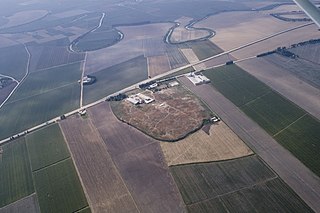
Abu Zurayq is an archaeological site located on the western edge of the Jezreel Valley and its transition to the Menashe Heights, next to Highway 66, between the modern kibbutzim of HaZore'a and Mishmar HaEmek.

<span class="mw-page-title-main">Shengavit Settlement</span> Archaeological site in present-day Yerevan, Armenia

The Shengavit Settlement is an archaeological site in present-day Yerevan, Armenia located on a hill south-east of Yerevan Lake. It was inhabited during a series of settlement phases from approximately 3000 BC cal to 2500 BC cal in the Kura Araxes (Shengavitian) Period of the Early Bronze Age and irregularly re-used in the Middle Bronze Age until 2200 BC cal. The town occupied an area of six hectares. It appears that Shengavit was a societal center for the areas surrounding the town due to its unusual size, evidence of surplus production of grains, and metallurgy, as well as its monumental 4 meter wide stone wall. Three smaller village sites of Moukhannat Tepe, Khorumbulagh, and Tairov have been identified and were located outside the walls of Shengavit. Its pottery makes it a type site of the Kura-Araxes or Early Transcaucasian Period and the Shengavitian culture area.

<span class="mw-page-title-main">Tell Qaramel</span> Archaeological site in Syria

Tell Qaramel is a tell, or archaeological mound, located in the north of present-day Syria, 25 km north of Aleppo and about 65 km south of the Taurus mountains, adjacent to the river Quweiq that flows to Aleppo.

<span class="mw-page-title-main">Tell Sabi Abyad</span> Archaeological site in ar-Raqqah, Syria

Tell Sabi Abyad is an archaeological site in the Balikh River valley in northern Syria. It lies about 2 kilometers south of Tell Hammam et-Turkman.The site consists of four prehistoric mounds that are numbered Tell Sabi Abyad I to IV. Extensive excavations showed that these sites were inhabited already around 7500 to 5500 BC, although not always at the same time; the settlement shifted back and forth among these four sites.

The Little Egypt site was an archaeological site located in Murray County, Georgia, near the junction of the Coosawattee River and Talking Rock Creek. The site originally had three platform mounds surrounding a plaza and a large village area. It was destroyed during the construction of the Dam of Carters Lake in 1972. It was situated between the Ridge and Valley and Piedmont sections of the state in a flood plain. Using Mississippian culture pottery found at the site archaeologists dated the site to the Middle and Late South Appalachian culture habitation from 1300 to 1600 CE during the Dallas, Lamar, and Mouse Creek phases.

Sanganakallu is an ancient archaeological site from the Neolithic period. It is approximately 8 km from Bellary in eastern Karnataka. It is a group of hills south of a horseshoe shaped valley, with Kupgal to the north. It is one of the earliest settlements in South India, spread over 1,000 acres. There is a layer of red-brown fossilized soil spread over Sanganakallu and Kupgal that can be dated back to 9000 BC. The site is considered to be a neolithic factory site due to the surface excavation revealing large numbers of pottery, stone axes, and other stone tools. The site was first majorly excavated in 1946, by Bendapudi Subbarao, on Sannarasamma hill. Subbarao divided their culture into 3 phases:

Periano Ghundai meaning "The Hill of Fairies" was an archaeological mound located in the Zhob district in Balochistan, Pakistan. The site is located 3 kilometres (1.9 mi) west of the town of Zhob. It was excavated in 1924 by Sir Aurel Stein and showed great resemblance to the Harappan culture.

Tell Judaidah is an archaeological site in south-eastern Turkey, in the Hatay province. It is one of the largest excavated ancient sites in the Amuq valley, in the plain of Antioch. Settlement at this site ranges from the Neolithic through the Byzantine Period.

<span class="mw-page-title-main">Sang-i Chakmak</span> Neolithic archaeological site in Iran

Sang-i Chakmak is a Neolithic archaeological site located about 1 km (0.62 mi) north of the village of Bastam in the northern Semnan Province of Iran, on the southeastern flank of the Elburs Mountains. The site represents quite well the transition from the aceramic Neolithic phase in the general area; this was taking place during the 7th millennium BC.

<span class="mw-page-title-main">Sohr Damb</span> Archaeological site in Pakistan

Sohr Damb, c. 3800–2300 BC, is an archaeological site, located near Nal, in central Balochistan, Pakistan that begins before the Indus Valley civilization featuring Togau, Kili Ghul Mohammad, and Kechi Beg pottery styles. It has also been known as Naal, Balochistan, and gave its name to the prehistoric Amri-Nal culture, which is attributed to the dual typesites of Amri and Nal.

Hiwassee Island, also known as Jollys Island and Benham Island, is located in Meigs County, Tennessee, at the confluence of the Tennessee and Hiwassee Rivers. It is about 35 mi (56 km) northeast of Chattanooga. The island was the second largest land mass on the Tennessee River at 781 acres before the Tennessee Valley Authority created the Chickamauga Lake as a part of the dam system on the Tennessee River in 1940. Much of the island is now submerged, leaving 400 acres above the waterline.

Early Agricultural Communities in Bengal were a group of Chalcolithic farmers, who first developed agriculture in Bengal. No archaeological evidence of large-scale agriculture in Bengal during the Neolithic period preceding the Chalcolithic or Copper Age.

Bharatpur is an archaeological site of Early village farming culture located in the Indian state of West Bengal. Construction of the settlement is believed to have started around 1735–1417 BC.

References

  1. 1 2 3 Chattopadhyay et al. 2013, p. 95.
  2. 1 2 3 4 5 6 Chattopadhyay et al. 2013, p. 97.
  3. 1 2 Chattopadhyay et al. 2013, pp. 96–97.
  4. 1 2 3 Chattopadhyay et al. 2013, pp. 126–127.
  5. 1 2 "Excavations – Since Independence – West Bengal « Archaeological Survey of India". asi.nic.in. Retrieved 29 September 2023.
  6. Deshpande-Mukherjee & Chattopadhyay 2023, p. 153.
  7. 1 2 Majumder et al. 2017, p. 606.
  8. 1 2 Chattopadhyay et al. 2013, pp. 130–131.
  9. 1 2 3 Chattopadhyay et al. 2015, pp. 242–243.
  10. Tewari 2015a, pp. 129–31.
  11. Tewari 2015a, p. 128.
  12. Chattopadhyay et al. 2013, p. 121.
  13. Chattopadhyay et al. 2013, pp. 121–122.
  14. Chattopadhyay et al. 2013, pp. 123–124.
  15. Chattopadhyay et al. 2013, pp. 116–17.
  16. Deshpande-Mukherjee & Chattopadhyay 2023, p. 160.
  17. 1 2 Chattopadhyay et al. 2013, pp. 117–119.
  18. Tewari 2015a, p. 129.
  19. 1 2 Tewari 2015a, pp. 133–34.
  20. Tewari 2015b, p. 184.
  21. Majumder et al. 2017, p. 608.
  22. Majumder et al. 2017, p. 611.
  23. Majumder et al. 2017, p. 617.
  24. Chattopadhyay et al. 2013, pp. 111–117.
  25. Tewari 2015a, p. 133.
  26. Chattopadhyay et al. 2013, p. 110.

Bibliography