The Chalcolithic was an archaeological period characterized by the increasing use of smelted copper. It followed the Neolithic and preceded the Bronze Age. It occurred at different periods in different areas, but was absent in some parts of the world, such as Russia, where there was no well-defined Copper Age between the Stone and Bronze ages. Stone tools were still predominantly used during this period.

A paddy field is a flooded field of arable land used for growing semiaquatic crops, most notably rice and taro. It originates from the Neolithic rice-farming cultures of the Yangtze River basin in southern China, associated with pre-Austronesian and Hmong-Mien cultures. It was spread in prehistoric times by the expansion of Austronesian peoples to Island Southeast Asia, Southeast Asia including Northeastern India, Madagascar, Melanesia, Micronesia, and Polynesia. The technology was also acquired by other cultures in mainland Asia for rice farming, spreading to East Asia, Mainland Southeast Asia, and South Asia.

The Hooghly River or popularly called Ganga or Kati-Ganga in the Puranas, is a river that rises close to Giria, which lies north of Baharampur and Palashi in Murshidabad. It is the western distributary of the Ganges. The main course of the Ganges then flows into Bangladesh as the Padma. A man-made canal, built in the 1960s and early-1970s at Farakka, connects the Ganges, flowing through Malda, to the Hooghly to bring the abundant waters of the Himalayan river to the comparatively narrow river that rises in eastern West Bengal.

Birbhum district is an administrative unit in the Indian state of West Bengal. It is the northernmost district of Burdwan division—one of the five administrative divisions of West Bengal. The district headquarters is in Suri. Other important cities are Bolpur, Rampurhat and Sainthia. Jamtara, Dumka and Pakur districts of the state of Jharkhand lie at the western border of this district; the border in other directions is covered by the districts of Bardhaman and Murshidabad of West Bengal.

The Hilly Flanks are the upland areas surrounding the Fertile Crescent of Southwest Asia, including the foothills of the Zagros Mountains, the Taurus Mountains, and the highland parts of the Levant. The Hilly Flanks foothill chain spans over 1000 miles, including parts of Turkey, northwestern Iraq, and western Iran. The region is just north of Mesopotamia, with similar characteristics of fertility with the added trait of foothills and plateaus.

Bardhaman district was a district in West Bengal. On 7 April 2017, the district was bifurcated into two districts: Purba Bardhaman and Paschim Bardhaman district. The headquarters of the district was Bardhaman, and it housed the cities of Asansol and Durgapur. Indian revolutionary Rashbehari Bose was born in village Subaldaha, Bardhaman district. Bengali poet Kumud Ranjan Mullick was born at Kogram and poet Kazi Nazrul Islam was born at Churulia in the same district. Notable persons like Prabhat Kumar Mukhopadhyay, Akshay Kumar Datta, Jatindranath Sengupta were also born in erstwhile Bardhaman district. It was the seventh most populous district in India at the time of bifurcation.

The Geography of West Bengal, a state in eastern India, is primarily defined by plains and plateaus, with the high peaks of the Himalayas in the north and the Bay of Bengal to the south.

Rarh region is a toponym for an area in the Indian subcontinent that lies between the Chota Nagpur Plateau on the West and the Ganges Delta on the East. Although the boundaries of the region have been defined differently according to various sources throughout history, it is mainly coextensive with the state of West Bengal, also comprising parts of the state of Jharkhand in India. Linguistically, the region is defined with population speaking the Rarhi Bengali local Bengali dialect.

State Archaeological Museum in Kolkata, West Bengal, is an archeological museum founded in 1962 and has collections including rare tools of the Early, Middle and the Late Stone Ages from Susunia (Bankura) and other sites, proto-historic antiquities from Pandu Rajar Dhibi (Burdwan), terracottas, sculptures, stone and stucco from the Gupta, Maurya, Shunga, Kushana, Pala and Medieval times. It is located at the vicinity of Behala Bazar Metro on Diamond Harbour Road and Nafar Chandra Das Road at Behala behind Siddeshwari Kali Temple
The prehistory of the Levant includes the various cultural changes that occurred, as revealed by archaeological evidence, prior to recorded traditions in the area of the Levant. Archaeological evidence suggests that Homo sapiens and other hominid species originated in Africa and that one of the routes taken to colonize Eurasia was through the Sinai Peninsula desert and the Levant, which means that this is one of the most occupied locations in the history of the Earth. Not only have many cultures and traditions of humans lived here, but also many species of the genus Homo. In addition, this region is one of the centers for the development of agriculture.
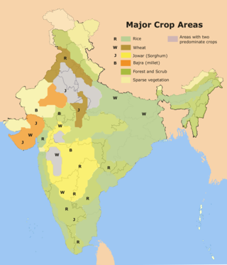
Rice production in India is an important part of the national economy.

Pandu Rajar Dhibi in the valley of the river Ajay is an Archaeological site in Ausgram II block in the Sadar North subdivision of Purba Bardhaman district in the Indian state of West Bengal. It was the first Chalcolithic site discovered in West Bengal. It was excavated by a team led by Paresh Chandra Dasgupta. The common man believes that the main mound at Pandu Rajar Dhibi is associated with King Pandu mentioned in the epic Mahabharata, hence the name came into being from the folklore.
Dihar is a village and an ancient archaeological site of great antiquarian importance brought into the limelight by Maniklal Sinha. Located in the Bishnupur subdivision of the Bankura district in the Indian state of West Bengal. It is 8 kilometres (5.0 mi) north of Bishnupur and is near Dharapat.

The prehistory of the Iranian plateau, and the wider region now known as Greater Iran, as part of the prehistory of the Near East is conventionally divided into the Paleolithic, Epipaleolithic, Neolithic, Chalcolithic, Bronze Age and Iron Age periods, spanning the time from the first settlement by archaic humans about a million years ago until the beginning of the historical record during the Neo-Assyrian Empire, in the 8th century BC.
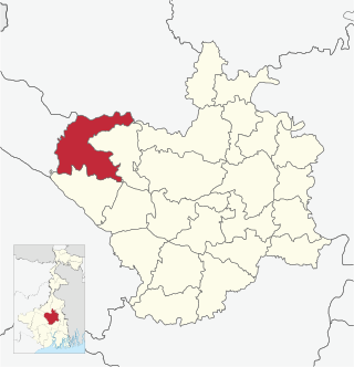
Ausgram II is a community development block that forms an administrative division in Bardhaman Sadar North subdivision of Purba Bardhaman district in the Indian state of West Bengal.
Majhdia, also known as Majdia, is a village in the Krishnaganj CD block in the Krishnanagar Sadar subdivision of the Nadia district, West Bengal, India.

Purba Bardhaman district is in the Indian state of West Bengal. Its headquarters is in Bardhaman. It was formed on 7 April 2017 after the division of the previous Bardhaman district. Great revolutionary Rash Behari Bose was born in village Subaldaha in the district of Purba Bardhaman.
Bamanpukur is a census town in the Nabadwip CD block in the Krishnanagar Sadar subdivision of the Nadia district in the state of West Bengal, India.

The history of West Bengal basically refers to the history of the western part of Bengal, located in the eastern part of the Indian subcontinent. Evidence of human settlement has been found in West Bengal about 42,000 years ago. The presence of human settlement of that period has been found in the Ayodhya Hills of West Bengal. By 2,000 BCE, settled life had increasingly spread of human civilization in the Damodar-Ajay River Valley, which was contemporary with the Harappa-Mahenjodaro civilization. The southern part of West Bengal witnessed the presence of the Vanga Kingdom between 1100 BCE and 350 BCE, which was contemporary with the Vedic civilization of northern India.
Erenda was one of the southernmost sites of Neolithic and Early farming culture located in the coastal region of the Indian state of West Bengal. Construction of the settlement is believed to have started around 2000 BC.
