
Arunachal Pradesh is a state in Northeastern India. It was formed from the erstwhile North-East Frontier Agency (NEFA) region, and became a state on 20 February 1987. It borders the states of Assam and Nagaland to the south. It shares international borders with Bhutan in the west, Myanmar in the east, and a disputed border with China in the north at the McMahon Line. Itanagar is the state capital of Arunachal Pradesh. Arunachal Pradesh is the largest of the Seven Sister States of Northeast India by area. Arunachal Pradesh shares a 1,129 km border with China's Tibet Autonomous Region.

Itanagar is the capital and largest town of the Indian state of Arunachal Pradesh. The seat of Arunachal Pradesh Legislative Assembly, the seat of government of Arunachal Pradesh, and the seat of Gauhati High Court permanent bench at Naharlagun are all in Itanagar. Being the hub of all the major economic bases, Itanagar along with the adjacent town of Naharlagun comprising the administrative region of Itanagar Capital Complex Region stretching from the Itanagar Municipal limit at Chandranagar Town extended till Nirjuli Town, is a major junction of Cultural, economic, fashion, education and recreational activities.

The Antonov An-32 is a turboprop twin-engined military transport aircraft.
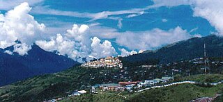
Tawang is a town and administrative headquarter of Tawang district in the Indian state of Arunachal Pradesh. The town was once the capital of the Tawang Tract, which is now divided into the Tawang district and the West Kameng district. Tawang continues as the headquarters of the former.

Pawan Hans Limited is a central public sector undertaking based at Noida in Delhi NCR, India. It is under the ownership of Ministry of Civil Aviation, Government of India. It has cumulatively flown more than 1 million hours and has had 2.5 million landings on its fleet since its formation. The headquarter is located at Sector-1 in Noida with regional office at Delhi and the operations are based at the Juhu Aerodrome in Vile Parle (West), Mumbai.

Pasighat Airport is a regional airport serving Pasighat, Arunachal Pradesh, India.
Tezu Airport is a regional airport serving Tezu, Arunachal Pradesh, India. It is operated by the Airports Authority of India (AAI), which upgraded it to handle ATR-72 aircraft with night-landing facility. Prime Minister Narendra Modi inaugurated the upgraded airport on 9 February 2019. Scheduled commercial flights commenced from 19 August 2021.
Zero Airport or Ziro Airport is located at Ziro in the state of Arunachal Pradesh, India. In the past, Vayudoot and Air India operated daily flights to the airport. Now, Alliance Air operates flights to and from the airport.
The Ministry of Development of North Eastern Region is a Government of India ministry, established in September 2001, which functions as the nodal Department of the Central Government to deal with matters related to the socio-economic development of the eight States of Northeast India: Arunachal Pradesh, Assam, Manipur, Meghalaya, Mizoram, Nagaland, Tripura and Sikkim. It acts as a facilitator between the Central Ministries/ Departments and the State Governments of the North Eastern Region in the economic development including removal of infrastructural bottlenecks, provision of basic minimum services, creating an environment for private investment and to remove impediments to lasting peace and security in the North Eastern Region.
Nal Air Force Station, also known as Bikaner Air Force Station and Civil Airport Bikaner, is a domestic airport and an Indian Air Force Station, which serves the city of Bikaner in Rajasthan, India, located 13 km west of the city. The civil enclave within is operated by the Airports Authority of India (AAI) and regular scheduled flight under the UDAN scheme were inaugurated in 2017.

Mechukha or Menchukha is a town, assembly constituency and subdivision, situated 6,000 feet (1,829 m) above sea level in the Mechukha Valley of Yargep Chu/ Siyom River in Shi Yomi district of Arunachal Pradesh state of India. Before the 1950s, Mechuka valley was known as Pachakshiri.

Air Force Station Hindon is an Indian Air Force base under the Western Air Command (WAC). It is the biggest and largest air base in Asia. Its area measured 14 km rounded and 55 square kilometres (21 sq mi). This base celebrates Air Force Day on 8 October. It is located near Loni Ghaziabad in the state of Uttar Pradesh in the National Capital Region on the outskirts of Delhi, close to the Hindon River. Starting 2006, the annual Air Force Day Parade venue was shifted from Palam Airport to Hindon. There is one runway, aligned east–west (09-27), of 9,000 feet (2,700 m) length x 150 feet (46 m) width. The military airbase serves as the home of the IAF C-17 Globemaster and the IAF C-130J Super Hercules, the backbone of Strategic Heavy Air Lift division of the Indian Air Force. The Airports Authority of India (AAI) operates a civil enclave at Hindon as part of the government's Regional Connectivity Scheme (RCS).

Bareilly Airport is a domestic airport serving Bareilly, Uttar Pradesh, India at Indian Air Force's Trishul Air Base in Izzatnagar, located 6 kilometres (3.7 mi) north from the city centre.
Nellore Airport is a proposed greenfield airport project near Dagadarthi, India, intended to serve the Nellore district in Andhra Pradesh. The airport is to be developed on 1,352 acres (5.47 km2) of land with an estimated cost of ₹368 crore.

Itanagar Airport, also known as Hollongi Airport and officially named as Donyi Polo Airport, is a domestic airport serving Itanagar, the capital city of Arunachal Pradesh, India. It is located at Hollongi, situated 14 km (8.7 mi) south from the city centre, in the Papum Pare district. It is built by the Airports Authority of India, over an area of 320 hectares. The airport is the 16th airport of Northeast India. Prime Minister Narendra Modi laid the foundation stone for the airport on 9 February 2019. Construction was started on 15 December 2020, and was inaugurated on 19 November 2022, with flight services started by IndiGo to Kolkata and Mumbai from 28 November 2022.
Arunachal Frontier Highway (AFH), officially notified as the National Highway NH-913 and also called Bomdila-Vijaynagar Highway (BVH), connecting Bomdila Airstrip ALG & HQ in northwest to Vijaynagar Airstrip ALG & HQ in southeast via Nafra HQ-Sarli HQ-Huri Helipad ALG & HQ-Nacho HQ-Mechuka Airstrip ALG & HQ-Monigong HQ-Jido -Hunli HQ-Hayuliang Airstrip ALG HQ-Chenquenty-Hawai HQ-Miao HQ including 800 km greenfield section and network of new tunnels & bridges, is a 2-lane paved-shoulder under-construction national highway along the India-China LAC-McMahon Line border in the Indian state of Arunachal Pradesh. The 1,748 km-long (1,086 mi) highway itself will cost ₹27,000 crore (US$3.4 billion) and total cost including 6 additional inter-corridors is ₹40,000 crore (US$5.0 billion). In some places, this highway will run as close as 20 km from the LAC. To be constructed by MoRTH in 9 packages, all packages will be approved by the end of fy 2024-25 and construction will be completed in 2 years by 31 March 2027. This highway in the north & east Arunachal along the China border, would complement the Trans-Arunachal Highway and the Arunachal East-West Corridor as major highways spanning the whole state, pursuing the Look East connectivity policy.

Bhogapuram International Airport is a proposed greenfield international airport project to be built near Bhogapuram in Vizianagaram district, about 40 kilometres (25 mi) north-east of Visakhapatnam.

Kurnool Airport, officially known as Uyyalawada Narasimha Reddy Airport, is a greenfield airport at Orvakal, Kurnool district in the Indian state of Andhra Pradesh. It is situated on National Highway 40, about 18 km (11 mi) from Kurnool and 54 km (34 mi) from Nandyal. The airport is built in 1,008 acres (4.08 km2) at a cost of ₹153 crore (US$19 million) as a low-cost airport to improve connectivity to remote areas. The airport has begun commercial operations in March 2021.
Mandi Airport is a proposed greenfield airport to be built at Nag Chala in Mandi District in the Indian state of Himachal Pradesh. The airport will be built on a total of 698 acres. The Airports Authority of India (AAI) gave its clearance for the airport after visiting the site in May 2018. In August 2019, Himachal Pradesh Chief Minister Jai Ram Thakur requested the Fifteenth Finance Commission for a special purpose grant of Rs 2,000 crore towards construction of the airport for operation of wide-body aircraft. The AAI completed its Obstacle Limitation Surfaces survey for the project site in August 2019. The Ministry of Civil Aviation gave in-principle approval for the execution of the project with the help of the AAI in October 2019. In January 2020, AAI signed a Memorandum of Understanding (MoU) with the Himachal Pradesh Government to build and operate the airport through a Joint Venture Company. The airport will have a unidirectional runway, suitable for operation of aircraft up to ATR 72 initially. WAPCOS has been appointed as project consultant and has floated tenders for environmental impact assessment for the project following a site visit in July 2020.

