Barbil is a city and a Municipal Council in the Kendujhar district of the state of Odisha, India. The region around Barbil has one of the largest deposits of iron ore and manganese ore in the world. It is a major source of revenue generation for both the central and the state governments.
Jhumpura is a census town and a block in Kendujhar district in the Indian state of Odisha.

Kendujhar District, is an administrative district of Odisha. The district is one of the fifth Scheduled Areas of Odisha. The town of Kendujhar is the district headquarters. The district has three sub-divisions, Anandapur, Champua, and Kendujhar.

Rangeilunda Airport, also known as Brahmapur Airport, is a domestic airport serving the city of Berhampur in Odisha, India. It is located adjacent to Berhampur University at Rangeilunda, 10 km (6.2 mi) east of the city centre and 5 km (3.1 mi) from the famous Gopalpur-on-Sea beach. The airstrip was built by the British during World War II.
Kendujhargarh railway station, located in the Indian state of Odisha, serves Kendujhar in Kendujhar district. It is on the Padapahar–Jakhapura branch line.
Hirakud Airstrip, also known as Sambalpur Airstrip, is a public airstrip owned by Government of Odisha located 12 kilometres north of Sambalpur in western Odisha, India.

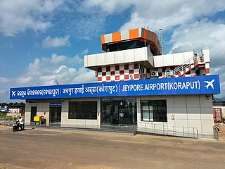
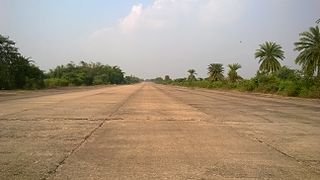
Jeypore Airport, also known as Jayapur Airport, is a domestic airport serving the cities of Jeypore and Koraput in Odisha, India. It is located 3 km (1.9 mi) north-west of the city of Jeypore in Koraput District. The airstrip was constructed in 1962 along with the establishment of a Hindustan Aeronautics Limited (HAL) factory nearby at Sunabeda. In the 1980s, Vayudoot operated a daily Bhubaneswar-bound flight via Visakhapatnam. Now, the new low-cost regional airline, IndiaOne Air, operates from the airport to Bhubaneswar and Vishakapatnam.

Amarda Road Airstrip, also known as Rasgovindpur Airstrip is a former wartime airfield located near Rasgovindpur village in Mayurbhanj district of Odisha, India. It was used by the Royal Indian Air Force during World War II.
Raisuan Airstrip, also known as Kendujhar Airstrip is a public airstrip located at Gopinathpur in the Kendujhar district of Odisha. Nearest airport to this airstrip is Barbil Tonto Aerodrome in Barbil, Odisha.
Tusura Airstrip, also known as Balangir Airstrip is a public airstrip located at Tusura in the Balangir district of Odisha. Nearest airport/airstrip to this airstrip is Utkela Airstrip in Bhawanipatna, Odisha. There are plans to upgrade the facility and use it as a second base for flight school by GATI in the state.
Angul Airport, also called Savitri Jindal Airport is a private airport owned by Jindal Steel and Power under DGCA license and located at Angul in the Angul district of Odisha, India. The airport is named after the Jindal group businesswoman and the richest woman in India, Savitri Jindal. The nearest airfield is Phulbani Airstrip in Phulbani, Odisha.
Gudari Airstrip, also known as Phulbani Airstrip, is a public airstrip owned by Government of Odisha located at Phulbani in the Kandhamal district of Odisha. Nearest airport/airstrip to this airstrip is Nuagaon Airstrip in Balangir, Odisha.
Nuapada Airstrip, also known as Gotma Airstrip, is a public airstrip located at Nandapur in the Nuapada district of Odisha. Nearest airport to this airstrip is Swami Vivekananda Airport in Raipur, Chhattisgarh.
Utkela Airport is owned by the Government of Odisha located at Utkela near Bhawanipatna of Kalahandi district, Odisha, India. The airstrip has been designated to be developed as a regional airport under the Regional Connectivity Scheme (UDAN).
Birasal Airstrip, also known as Dhenkanal Airstrip, is located 53 km from the Dhenkanal city center in central Odisha, India. Nearest airport to this airstrip is Biju Patnaik International Airport in the capital city Bhubaneswar i.e. 134 km.
Satibhata Airstrip also known as Padmapur Airstrip, is located 6 km from the Padmapur city center in western Odisha, India. Nearest airport to this airstrip is Raipur's Swami Vivekananda Airport in the state of Chhattisgarh. The airport serves Padmapur city in the Bargarh district of Odisha.
Gunupur Airstrip is a public airstrip owned by Government of Odisha located at Gunupur in the Rayagada district of Odisha. Nearest airport to this airstrip is Jeypore Airport in Jeypore, Odisha.
Rairangpur Airstrip, also known as Dandbose Airstrip, is located 6 km away from Rairangpur city center in Mayurbhanj district, Odisha, India. Rairangpur Airstrip is spread over 61 acres and is under the control of the Works Department of Government of Odisha. The runway is 750 meters long and is periodically maintained by the state government.
Therubali Airstrip is a private airport located 3.3 km from Therubali city center in Rayagada district, Odisha.The Airstrip is spread over 30 acres and is under the control of the Indian Metals and Ferro Alloys Ltd (IMFA). The runway is 1,135 meters long and is periodically maintained by the IMFA.


