Amarda Road Airstrip

Last updated

Amarda Road Airstrip
Amarda Road Airstrip.jpg
Summary
Airport typeDefunct
Owner Ministry of Defence [1]
Operator Indian Air Force [2]
LocationRasgovindpur, Odisha, India
Elevation  AMSL 130 ft / 43 m
Coordinates 21°48′18″N087°02′49″E / 21.80500°N 87.04694°E / 21.80500; 87.04694 Coordinates: 21°48′18″N087°02′49″E / 21.80500°N 87.04694°E / 21.80500; 87.04694
Map
India Odisha location map.svg
Airplane silhouette.svg
Amarda Road Airstrip
Location in Odisha
India location map.svg
Airplane silhouette.svg
Amarda Road Airstrip
Amarda Road Airstrip (India)
Runways
Direction LengthSurface
ftm
05/236,0001,830 Concrete
17/356,6702,032Concrete

Amarda Road Airstrip, also known as Rasgovindpur Airstrip is a former wartime airfield located near Rasgovindpur village in Mayurbhanj district of Odisha, India. It was used by the Royal Indian Air Force during World War II.

Contents

History

Wing Commander Frank Carey, Officer Commanding the Air Firing Training Unit, based at Amarda Road, India, standing by the nose of a Hawker Hurricane, in April 1943. Wing Commander Frank Carey, Officer Commanding the Air Firing Training Unit, based at Amarda Road, India, standing by the nose of a Hawker Hurricane, April 1943. CI171.jpg
Wing Commander Frank Carey, Officer Commanding the Air Firing Training Unit, based at Amarda Road, India, standing by the nose of a Hawker Hurricane, in April 1943.

The Baripada Road airstrip, as it was called in war terminology, spreads across an area of nearly 900 acres. Built in the 1940s at a cost of Rs 3 crore, it was eventually abandoned after the war. [3] It was probably named as Amarda Road Airfield because of the nearby Amarda Road railway station. The airfield was used by No. 136 Squadron RAF, [4] No. 177 Squadron RAF [5] and No. 607 Squadron RAF. The 'Air Fighting Training Unit', formed in February 1943, was also based here.

As an airfield, Amarda Road fell on the supply route for the Nationalist Armies of China in their fight against the Japanese. Aircraft of the RAF and the United States Army Air Forces (USAAF) would regularly fly from this space to China via Chabua (Dibrugarh), Jorhat and Vijaynagar across the infamous hump route over Arunachal and East Tibet.

Amarda Road and other neighbouring airfields - Dhalbhumgarh, Dudhkundi, Salua, Digri, Salbani and Chakulia - formed a web of airfields created by the Allies to stop the impending Japanese advance in the east. During the war, Amarda Road was, to put it simply, a battle hub. After the war was over, most airfields, including this one, fell into disuse. Today, only the Kalaikunda airstrip, which was declared an Air Force Station in 1954, exists.
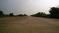
Present condition

Eight decades after the base was built, the 11,000 feet (3,400 m) concrete runway is still intact, though the buildings that once cluttered the edges are gone.

There are proposals to renovate the airstrip for future operations under UDAN scheme from 2022. [6] [7] As of November 2022, the Government of India and the Ministry of Defence have cleared for the airstrip to be developed as a commercial airport by acquiring a land area of 160 acres, and developing it at a cost of ₹ 25 crores. [8] [9]

Related Research Articles

<span class="mw-page-title-main">Kadapa Airport</span> Airport of Andhra Pradesh, India

Kadapa Airport is a regional airport serving Kadapa in Andhra Pradesh, India. It is located 12 km (7.5 mi) from the city, and is spread over 669.5 acres (270.9 ha) of land and has been upgraded at a cost of ₹ 42 crore. The upgraded airport was inaugurated on 7 June 2015 by the then Minister of Civil Aviation, Ashok Gajapathi Raju. The terminal building has a capacity to handle 100 peak hour passengers at a time and the apron can accommodate two ATR-72 aircraft.

<span class="mw-page-title-main">Bilaspur Airport</span> Airport in Chhattisgarh India

Bilaspur Airport, officially known as Bilasa Devi Kevat Airport is located at Chakarbhatta, 10 kilometres south of Bilaspur, in the state of Chhattisgarh, India. Bilaspur Airport made by Royal Air Force in 1942 oldest Airport of chhattisgarh. It is owned by the Airports Authority of India. In 1980s, the airport was used by Vayudoot to provide flights to Bhopal, Nagpur, Mumbai and Delhi. Currently commercial scheduled flight are operating from the airport to Indore, Delhi, Jabalpur, Allahabad.

<span class="mw-page-title-main">Mysore Airport</span> Airport in Mysore, India

Mysore Airport, also known as Mandakalli Airport, is a domestic airport serving Mysore, a city in the Indian state of Karnataka. It is located near the village of Mandakalli, 10 kilometres (6.2 mi) south of the city, and is owned and operated by the Airports Authority of India (AAI). As of January 2023, the airport has regular daily flights to Chennai, Hyderabad and Goa.

<span class="mw-page-title-main">Tiruchirappalli International Airport</span> International airport in Tiruchirapalli, India

Tiruchirappalli International Airport is an international airport serving Tiruchirappalli in the Indian state of Tamil Nadu. The airport spread over an area of 702.02 acres (284.10 ha) is located on National Highway 336, about 5 km (3.1 mi) south of the city centre. As of 2022, it is 31st busiest airport in India for passengers handled and 11th busiest for total international aircraft movement. It is the third busiest airport within Tamil Nadu in terms of total passenger traffic, after Chennai and Coimbatore.

Halwara Air Force Station is an Indian Air Force (IAF) base near Halwara town in Punjab, India. It is one of the oldest frontline airbases of the IAF and was actively involved in both, 1965 and 1971 Indo-Pak conflicts because of its strategic location. It is home to the 220 Squadron known as "Desert Tigers" and 221 Squadron known as "Valiants" flying the Sukhoi Su-30MKI.

Ayodhya Airport, officially known as Maryada Purushottam Shri Ram International Airport, is an under-construction international airport which will serve the city of Ayodhya in the Indian state of Uttar Pradesh. The airport is located adjacent to NH-27 and NH-330 at Naaka, Faizabad. The Government changed the name of the airport after Lord Shri Ram in 2021. The State Government signed a Memorandum of Understanding (MoU) with the Airports Authority of India (AAI) in February 2014 for the development of the airport.

<span class="mw-page-title-main">Jodhpur Airport</span> Airport in Jodhpur, India

Jodhpur Airport is a domestic airport and an Indian Air Force base serving the city of Jodhpur, Rajasthan, India. It is operated by the Airports Authority of India (AAI) and shares its airside with the Jodhpur Air Force Station of the Indian Air Force.

Kolhapur Airport, also known as Chhatrapati Rajaram Maharaj Airport, is a domestic airport serving the city of Kolhapur, Maharashtra, India. It is situated at Ujlaiwadi, 9 km (5.6 mi) southeast from the city. It is operated by the Airports Authority of India (AAI).

<span class="mw-page-title-main">Shillong Airport</span> Airport of Meghalaya

Shillong Airport is a domestic airport serving Shillong, the capital of Meghalaya, India. It is located at Umroi, situated 30 km (19 mi) from the city centre.

<span class="mw-page-title-main">Jaisalmer Airport</span> Airport of Rajasthan, India

Jaisalmer Airport is a domestic airport serving Jaisalmer, Rajasthan, India. It is located 12.6 kilometres (7.8 mi) from the city centre. The airport operates as a civil enclave on an Indian Air Force base.

<span class="mw-page-title-main">Rupsi Airport</span> Airport of Assam, India

Rupsi Airport is an airport located in Rupsi situated at Kokrajhar district near the border of Dhubri district of Assam.

<span class="mw-page-title-main">INS Parundu</span> Airport in Ramanathapuram, Tamil Nadu

INS Parundu is an Indian naval air station located near Uchipuli in the Ramanathapuram of the state of Tamil Nadu. It operates under the Eastern Naval Command of the Indian Navy. The air station will be opened up for civilian flights under Phase 2 of the Regional Connectivity Scheme (RCS) of the Government of India also known as UDAN and the Airports Authority of India (AAI) has started preparatory work at the airstrip. It is sandwiched between Rameswaram National Highway Road and Railway track which leads towards Rameswaram.

Moradabad Airport is an upcoming airport in Moradabad, situated midway between Moradabad and Rampur on National Highway 9 in Uttar Pradesh. It is developing by upgrading the existing government airstrip. The Government of Uttar Pradesh signed a Memorandum of Understanding (MoU) with the Airports Authority of India (AAI) in February 2014 for the development of this airstrip.

<span class="mw-page-title-main">Jalgaon Airport</span> Airport in Maharashtra, India

Jalgaon Airport is a domestic airport located off National Highway 753F southeast of the city of Jalgaon in Maharashtra, India. It has flights to Mumbai, Ahmedabad, Nanded, and Kolhapur operated by TruJet. Jalgaon Airport is 47 km away from the Ajanta Caves for which it is its closest airport.

Hisar Airport, officially known as Maharaja Agrasen International Airport existing as domestic airport presently under upgrade by 30 March 2024, is a DGCA-licensed public airport serving Hisar in Haryana state of India. It is located 5 kilometres (3.1 mi) north-east of the city center on NH-9. Hisar is a National Capital Region Counter Magnet City on the 'Hisar-Narnaul Industrial Sub-corridor' of Delhi Mumbai Industrial Corridor Project (DMIC).

Jeypore Airport or Jayapura Airport is a domestic airport serving Jeypore, Odisha, India. It is located three kilometres (1.9 mi) north-west of the city of Jeypore in Koraput District, serving the city of Koraput, Odisha, India. The airstrip was constructed in 1962 along with the establishment of a Hindustan Aeronautics Limited (HAL) factory nearby at Sunabeda. In the 1980s, Vayudoot operated a daily Bhubaneswar-bound flight via Visakhapatnam.

Bokaro Airport is a domestic airport owned by Steel Authority of India Limited and operated by Airport Authority of India. The airport is located in Sector 12, approximately 4.1 km (2.5 mi) from the city centre. The airport was included in the UDAN regional connectivity scheme and its expansion is underway to facilitate scheduled operations.

<span class="mw-page-title-main">Adampur Airport</span> Airport in Punjab, India

Adampur Airport, Jalandhar is the primary airport serving the cities of Jalandhar and Hoshiarpur in Punjab, India. It is located at Adampur Town of Jalandhar district in Northern India, on the Jalandhar-Hoshiarpur main highway 23 km northeast of Jalandhar, Punjab, India. The airport was required by the Doaba Region of Punjab as the two other main airports Sri Guru Ram Dass Jee International Airport and Chandigarh International Airport are 100 and 145 km distant respectively.

<span class="mw-page-title-main">UDAN</span> Indian airport development plan

Ude Desh ka Aam Naagrik, known by its acronym UDAN is a regional airport development program of the Government of India and part of the Regional Connectivity Scheme (RCS) of upgrading under-serviced air routes. Its goal is to make air travel affordable and improve economic development in India. At the beginning of the scheme, out of total of 486 airports, 406 were under-serviced airports, 27 were well-served airports, out of 97 non-RCS airports only 12 were operational airports, out of 18 participating airports under-served regional operational airports with regular fixed-wing scheduled flights. UDAN scheme will add to this number by expediting the development and operationalization of India's potential target of nearly 425 unserved, under-served, and mostly underdeveloped regional airports with regularly scheduled flights. However, there are several issues and criticisms such as poor infrastructure, dominance by larger airlines and degradation of regional airlines, slow implementation that plague this scheme.

<span class="mw-page-title-main">Darbhanga Airport</span> Domestic airport in Darbhanga,Bihar, India

Darbhanga Airport is a domestic airport and an Indian Air Force Station, serving Darbhanga, Bihar, India. It is located just at the outskirts of the city near the NH-105 and NH-57 highways, which pass through Darbhanga. The airport is operated by the Airports Authority of India (AAI). The foundation stone for the airport was laid by the then Chief Minister Nitish Kumar and then Civil Aviation Minister Suresh Prabhu, in the presence of state Civil Aviation Minister Jayant Sinha on 24 December 2018. Commercial flights started on 8 November 2020 and also available connecting flight for international flights.

References

  1. "List of Airstrip in the State maintained by State Government" (PDF). ct.odisha.gov.in. Commerce and Transport Department, Government of Odisha. Retrieved 14 January 2023.
  2. "AAI Unserved Airports" (PDF). aai.aero. Airports Authority of India.
  3. Sahoo, Akshaya Kumar (29 April 2018). "WW-II era Amarda airstrip in Odisha cries for attention". The Asian Age.
  4. Jacobs, Vivian K. The Woodpecker Story. Durham, UK: The Pentland Press Ltd., 1994. ISBN   1-85821-235-9. 1994, p. 156.
  5. C.G.Jefford (1988). RAF Squadrons. UK Airlife Publishing. ISBN   1-85310-053-6.
  6. "Amarda airstrip revamp in 2022: Bishweswar Tudu". The New Indian Express. 9 September 2021.
  7. "Rasgobindpur now under UDAN scheme". Daily Pioneer. 20 June 2021.
  8. Barik, Satyasundar (23 November 2022). "Decks cleared for development of World War II era airstrip into an airport in Odisha". The Hindu. Retrieved 26 November 2022.
  9. Bisoyi, Sujit (23 November 2022). "President Droupadi Murmu's home district to have airport, gets MoD nod". The Indian Express. Retrieved 26 November 2022.