
The Chenab valley in Jammu and Kashmir has high tourism potential. There are a number of tourist attractions with history and traditions. [1] It consists of;
The Chenab valley in Jammu and Kashmir has high tourism potential. There are a number of tourist attractions with history and traditions. [1] It consists of;

The Chenab River is a major river that flows in India and Pakistan, and is one of the 5 major rivers of the Punjab region. It is formed by the union of two headwaters, Chandra and Bhaga, which rise in the upper Himalayas in the Lahaul region of Himachal Pradesh, India. The Chenab flows through the Jammu region of Jammu and Kashmir, India into the plains of Punjab, Pakistan, before ultimately flowing into the Indus River.

Doda district is an administrative district of the Jammu division of Indian-administered Jammu and Kashmir in the disputed Kashmir region.

Bhaderwah or Bhadarwah is a town, tehsil, sub-division and also additional district in the Doda district of the Jammu Division of Jammu and Kashmir, India. It is also known as Chota Kashmir for its scenery and for its high literacy rate it is known as Kerala of Jammu and Kashmir.
Tawi is a river that flows through the city of Jammu in the Indian union territory of Jammu and Kashmir. The Tawi is a major left bank tributary of the river Chenab. Tawi river is considered sacred and holy, as are most rivers in India.

The valleys of Jammu and Kashmir include the Kashmir Valley, Chenab Valley, Sindh Valley, and Lidder Valley. Srinagar, with its renowned Dal Lake and Mughal Gardens, Gulmarg, Pahalgam, Bhaderwah, Patnitop, and Jammu are all popular tourist destinations in Jammu and Kashmir. Thousands of Hindu pilgrims visit the sacred temples of Vaishno Devi and Amarnath each year, which has a substantial impact on the state's economy.

Kishtwar district is an administrative district of the Jammu division of Indian-administered Jammu and Kashmir in the disputed Kashmir region. As of 2011, it is the largest and the least populous district of Jammu and Kashmir.
Salooni is the tehsil headquarter and Sub-Division in Chamba district of Himachal Pradesh, India. Salooni is an important regional administrative and economic centre. It has a mini secretariat, SDM office, government senior secondary school, Degree College, community health centre and many other sub-division level important government offices. Salooni falls under Dalhousie legislative constituency. The entrance to the small township has a series of few quaint shops, followed by small ground with an ancient goddess Kali temple at other end.

Machail Chandi Mata Temple, popularly known as Machail Mata, is a shrine of the Hindu goddess Durga in the village Machail of Sub Division Paddar, in Kishtwar District of Jammu region in the Indian union territory of Jammu and Kashmir. It is near tributaries of the Chenab River. The area is home to a Buddhist community and the Thakur community who are serpent worshipers, and was merged with Kishtwar tehsil, by Maharaja Ranbir Singh. Thousands of pilgrims, mainly from Jammu region, visit the shrine every August.
Paddar, also spelled Padar, is a Sub-District and remote valley in the Kishtwar district of the union territory of Jammu and Kashmir, India. It falls in the Jammu division. It consists of two tehsils namely Machail and Atholi Paddar The valley covers the entire southeastern portion of the Kishtwar district. It borders Zanskar (Ladakh) in the north and east, Pangi in the south and the rest of Jammu and Kashmir in the west. The valley is known for its Sapphire mines. Albeit Sapphires are located in the valley of Paddar in Jammu division, they are known as Kashmiri sapphires which is a misnomer. It lies along the Chandrabhaga river (Chenab) in the Great Himalayas. Paddar is among one of the most remote regions of Jammu and Kashmir. There are various small valleys within Paddar, such as Machail, Gandhari, Kabban, Ongai, Bhuzunu, Barnaj, Bhuzas, Kijai Nallah, and Dharlang, among others.
The Chenab Valley is a river valley formed by the Chenab River. The term is also used collectively for Doda, Kishtwar and Ramban districts of Jammu Division in Jammu and Kashmir, India. These districts were formerly part of a single district, called Doda.

Sinthan Top is a mountain pass, a popular tourist destination located between South Kashmir's Breng Valley in Kishtwar district of Chenab Valley in the Indian union territory of Jammu and Kashmir. Majority of the area lies on the Kishtwar side. The top acts as a sort of base camp to several alpine lakes in the region.

The Jammu division is a revenue and administrative division of the Indian-administered Jammu and Kashmir in the disputed Kashmir region. It is bordered by the Kashmir division to the north. It consists of the districts of Jammu, Doda, Kathua, Ramban, Reasi, Kishtwar, Poonch, Rajouri, Udhampur and Samba. Most of the land is hilly or mountainous, including the Pir Panjal Range which separates it from the Kashmir Valley and part of the Great Himalayas in the eastern districts of Doda and Kishtwar. Its principal river is the Chenab.

Thathri is a town and a notified area committee in Doda district in the Indian union territory of Jammu and Kashmir. Thathri valley is located in the foothills of the Himalayan mountains, about 85 km from Batote. Apart from having ample forests, the town contains many small streams flowing through its various parts. It is located on the banks of the Chenab River and the town area is spread over 1.50 sq. Km².
Saraz or Siraj is a hilly region in the eastern part of the Jammu division of Jammu and Kashmir in northern India. Historically a pargana within the erstwhile state of Kishtwar, the region currently takes up the northern half of Doda district and parts of neighbouring Ramban and Kishtwar districts. Its population in 2011 stood at 180,000 people. The region is defined mainly on the basis of linguistics where the majority of people speak Sarazi as their mother tongue.

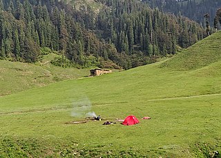
Jai Valley is an enchanting valley located 32 kilometres (20 mi) northeast of Bhaderwah town in Jammu and Kashmir, India. The Bhaderwah-Jai road, which passes through the corniferous deodar forests of Nakshri, Balote, Bhalara and Chinta Valley connects the valley with the Bhaderwah town. The valley has green meadows which act as the attraction for tourists in summers and the snow-covered landscape during winters. Jai valley has about 9 kilometres (5.6 mi) long meadows, bisected by a stream called Jai Nallah which merges with a tributary of river Chenab at Kahara in tehsil Thathri. It is also known by the names Jai Garh and Jai Top. The valley is also connected through a 37 kilometres (23 mi) long road with Gandoh. There is no Mobile Network in this valley.
Bhal Padri is a hill station situated above a group of small valleys covered with a dense forest located in the Changa, Bhalessa. area of Doda district. It borders Padri Pass, Bhaderwah at a distance of 4 kilometres (2.5 mi) northeast. Rivulets and streams flow through this valley.

Bhalessa is a geographical area within Doda district in the Jammu region of India-administered Kashmir. It consists of the Bunjwah and Bhalessa Valleys, and comprises the three Tehsils of Kahara, Chilly Pingal and Gandoh.
Gatha is a village located in the Bhaderwah Tehsil in the Doda district of the Indian-administered union territory of Jammu and Kashmir.
The Jamia Masjid Bhaderwah is a mosque located in the town of Bhaderwah, in the Doda district of Indian-administered union territory of Jammu and Kashmir.
| By state |
|
|---|---|
| By city | |
| Types |
|
| Organisations |
|
| See also | |