
Anantnag district is an administrative district of Indian-administered Jammu and Kashmir in the disputed Kashmir region. It is one of ten districts which make up the Kashmir Valley. The district headquarters is Anantnag city. As of 2011, it was the third most populous district of Jammu and Kashmir, after Jammu and Srinagar.
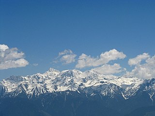
The Pir Panjal Range is a range of mountains in the Lower Himalayan region located in the Western Himalayas of northern Indian subcontinent. It runs southeast to northwest between the Beas and Neelam/Kishanganga rivers, in the Indian state of Himachal Pradesh and Indian-administered union territory of Jammu and Kashmir, with its northwestern end extending into territory administered by Pakistan. The Himalayas show a gradual elevation towards the Dhauladhar and Pir Panjal ranges. Pir Panjal is the largest and westernmost range of the Lesser Himalayas. Near the bank of the Sutlej River, it dissociates itself from the main Himalayan range and forms a divide between the Beas and Ravi rivers on one side and the Chenab on the other. Further west, the Pir Panjal range forms the southwestern boundary of the Kashmir Valley, separating it from the hills of Jammu region, forming a divide between the Jhelum and Chenab rivers.
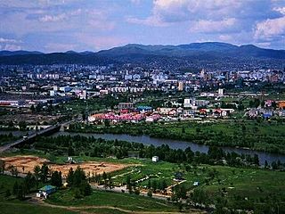
Anantnag, also called Islamabad, is the administrative headquarters of Anantnag district of Indian-administered Jammu and Kashmir in the disputed Kashmir region. It is located at a distance of 53 kilometres from the union territory's capital Srinagar. It is the third largest city in Jammu and Kashmir after Srinagar and Jammu with an urban agglomerate population of 159,838 and a municipal limit population of 109,433.

Verinag is a town named after and famous for the Verinag spring and Mughal garden, near Anantnag city in the Anantnag district of the union territory of Jammu and Kashmir, India. It is also called "gateway of Kashmir" and is a notified area committee with tehsil status and is about 26 kilometers away from Anantnag and approximately 78 kilometres south-east from Srinagar which is the summer capital of the union territory of Jammu and Kashmir. Verinag is also the first tourist spot of Kashmir Valley when travelling by road from Jammu, the winter capital of the union territory of Jammu and Kashmir towards Srinagar. There is an octagonal stone basin at Verinag Spring and an arcade surrounding it which were built by Mughal emperor Jahangir in 1620 A.D. Later, a beautiful garden next to this spring, was laid out by his son Shah Jahan. This spring is known to never dry up or overflow. Verinag Spring is also the major source of river Jhelum. Verinag Spring and Mughal Arcade surrounding it is officially recognized by Archaeological Survey of India as a Monument of National Importance.
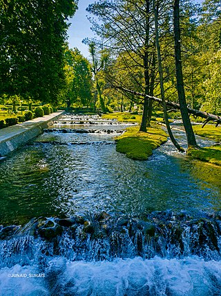
Kokernag is a sub-district town and a notified area committee in Breng Valley, Anantnag district in the Indian union territory of Jammu and Kashmir. The place is known for the botanical gardens, pristine freshwater springs, and rainbow trout farm. It is 25.3 km from Anantnag via NH244. It is one of the most popular weekend getaways from the state capital of Srinagar.

Pahalgam, known as Pahalgom is a town and a notified area committee, near Anantnag city in the Anantnag district of the Indian-administered union territory of Jammu and Kashmir. It is a popular tourist destination and hill station. Its lush green meadows and pristine waters attract thousands of tourists from all over the world each year. It is located 45 kilometres (28 mi) from Anantnag on the banks of Lidder River at an altitude of 7,200 feet (2,200 m). Pahalgam is the headquarters of one of the eleven tehsils of Anantnag district.

Sonamarg or Sonmarg, known as Sonamarag in Kashmiri, is a hill station located in the Ganderbal District of Jammu and Kashmir, India. It is located about 62 kilometers from Ganderbal Town and 80 kilometres (50 mi) northeast of the capital city, Srinagar.

Jammu and Kashmir is home to several valleys such as the Kashmir Valley, Chenab Valley, Sindh Valley and Lidder Valley. Some major tourist attractions in Jammu and Kashmir are Srinagar, with its renowned Dal Lake and Mughal Gardens, Gulmarg, Pahalgam, Bhaderwah, Patnitop and Jammu. Every year, thousands of Hindu pilgrims visit holy shrines of Vaishno Devi and Amarnath which has had a significant impact on the state's economy.

Kishtwar district is an administrative district of the Jammu division of Indian-administered Jammu and Kashmir in the Jammu Division. As of 2011, it is the largest and the least populous district of Jammu and Kashmir.
Daksum Is a natural scenic spot located in the Larnoo tehsil of Anantnag district, Jammu and Kashmir, at Anantnag-Semthan-Kishtwar road (NH-244).
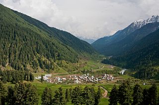
Aru known as Adu in Kashmiri, is a village, tourist spot in the Anantnag District of Jammu and Kashmir, India. It lies 53km from Anantnag city, the district headquarter. It is located around 12 km from Pahalgam, 11 km upstream from the Lidder River. Noted for its scenic meadows, lakes and mountains, it is a base camp for trekking to the Kolhoi Glacier, Tarsar Lake, Marsar and Herbaghwan Lake. The village lies on the left bank of the Aru river, which is a tributary of the Lidder river. Jammu & Kashmir’s biggest Fodder Seed Product Station is also located in the Aru village.

The Lolab Valley is a Himalayan valley located in the Kupwara district of the Indian union territory of Jammu and Kashmir. The entrance to the valley lies 1 km (0.62 mi) east of Kupwara, and the centre of the valley lies 114 km (71 mi) northwest of Srinagar, the capital of Jammu and Kashmir. It is an oval-shaped valley 15 miles (24 km) long with an average width of 3 miles (4.8 km). Valley is at an altitude of 1,590 metres above the Sea level.
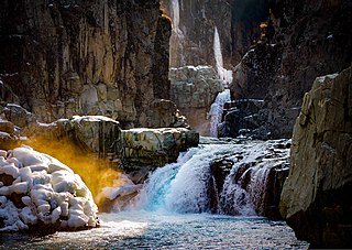
Aharbal is a hill station in the south-western part of Kashmir Valley in the Indian union territory of Jammu and Kashmir, south of the summer capital of Srinagar. Aharbal Waterfall is also known as Niagara Waterfall of Kashmir.
The Bringhi or Brengi river is a river in Anantnag, Jammu and Kashmir, India. It flows for a total of 30 kilometres (19 mi) before feeding Jhelum River at Haji Danter, Anantnag. It is formed by the confluence of three streams Nowbugh stream, Ahlan Gadol Stream, and Daksum Stream. Nowbugh Stream originates from the glaciers of Margan Top, Daksum Stream originates from the glaciers of Sinthan in Anantnag district. The river passes through a gorge at Daksum. Kokernag is in the Bringhi river valley. It is one of the tributary of river Jhelum. Sir Walter Lawrence wrote in his book The Valley of Kashmir that the brang river which disappears at Dewalgam village in the fissures of the limestone is the real source of the Achabal spring. Recently a sink hole appeared in the river at wandevelgam which sucked in the whole flow of the water. This is the second time a sink hole has appeared in this river.

The Jammu–Srinagar National Highway is the northernmost segment of NH 44. It runs from Srinagar in the Kashmir Valley southward to the city of Jammu.
Pattan, is a sub-district town and a municipal community in Baramulla district within the Indian Union Territory of Jammu and Kashmir.

Kumar Mohalla is a part of Akingam village in Anantnag district of Jammu and Kashmir and a part of tehsil Akingam. It enroutes Kashmir's best-known tourist resorts such as Achabal, Kokernag and Daksum. On one side of Kumar Mohalla Akingam there is a craft centre. Kumar Mohalla Akingam is known for earthenware.
National Highway 244 is a National Highway in India. It is located entirely within the union territory of Jammu and Kashmir. It was originally called National Highway 1B.
Margan Top or Margan Pass is a mountain pass, connecting Warwan Valley in Kishtwar District with the main Kashmir Valley. It is located south of Anantnag district in the Indian state of Jammu and Kashmir.


