Kalimpong is a town and the headquarters of an eponymous district in the Indian state of West Bengal. It is located at an average elevation of 1,250 metres (4,101 ft). The town is the headquarters of the Kalimpong district. The region comes under Gorkhaland Territorial Administration which is an autonomous governing body within the state of West Bengal. The Indian Army's 27 Mountain Division is located on the outskirts of the city.

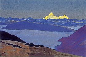
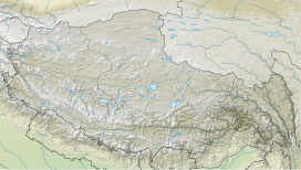
Nathu La(Tibetan: རྣ་ཐོས་ལ་, Wylie: Rna thos la, THL: Na tö la, Sikkimese: རྣ་ཐོས་ལ་) is a mountain pass in the Dongkya Range of the Himalayas between China's Yadong County in Tibet, and the Indian states of Sikkim. But minor touch of Bengal in South Asia. The pass, at 4,310 m (14,140 ft), connects the towns of Kalimpong and Gangtok to the villages and towns of the lower Chumbi Valley.

The history of Sikkim begins with the indigenous Lepcha's contact with early Tibetan settlers. Historically, Sikkim was a sovereign Monarchical State in the eastern Himalayas. Later a protectorate of India followed by a merger with India and official recognition as a state of India. Lepchas were the main inhabitants as well as the Rulers of the land up to 1641. Lepchas are generally considered to be the first people, Indigenous to Sikkim also includes Darjeeling.

Yadong County, also known by its Tibetan name Dromo/TromoCounty is a frontier county and trade-market of the Tibet Autonomous Region of China, part of its Shigatse Prefecture.

The Chumbi Valley, called Dromo or Tromo in Tibetan, is a valley in the Himalayas that projects southwards from the Tibetan plateau, intervening between Sikkim and Bhutan. It is coextensive with the administrative unit Yadong County in the Tibet Autonomous Region of China. The Chumbi Valley is connected to Sikkim to the southwest via the mountain passes of Nathu La and Jelep La.

The British expedition to Tibet, also known as the Younghusband expedition, began in December 1903 and lasted until September 1904. The expedition was effectively a temporary invasion by British Indian Armed Forces under the auspices of the Tibet Frontier Commission, whose purported mission was to establish diplomatic relations and resolve the dispute over the border between Tibet and Sikkim. In the nineteenth century, the British had conquered Burma and Sikkim, with the whole southern flank of Tibet coming under the control of the British Indian Empire. Tibet ruled by the Dalai Lama under the Ganden Phodrang government was a Himalayan state under the protectorate of the Chinese Qing dynasty until the 1911 Revolution, after which a period of de facto Tibetan independence (1912–1951) followed.

Yatung or Yadong, also known as Shasima , is the principal town in the Chumbi Valley or Yadong County in the Tibet Autonomous Region of China. It is also its administrative headquarters.
Bhutan House is an estate located in Kalimpong, West Bengal, India, owned by the Dorji family of Bhutan. The site is the traditional administrative Dzong for southern Bhutan, and also functioned as the administrative center for the whole of western Bhutan during the modern kingdom's early years of consolidation. It represented the relationship between Bhutan and British India, and is a modern symbol of Bhutan–India relations.

The Sikkim expedition was an 1888 British military expedition to expel Tibetan forces from Sikkim. The roots of the conflict lay in British–Tibetan competition for suzerainty over Sikkim.
Cho La or Cho-la is a mountain pass in the Chola range of the Himalayas. It connects the Indian state of Sikkim with China's Tibet Autonomous Region. It is situated around four miles to the north-west of Nathu La.

Gipmochi is a mountain in the Lower Himalayas in south central Asia. Rising to a height of 14,523 feet (4,427 m), the mountain sits on the border between the northern Indian state of Sikkim and Bhutan. China claims Gipmochi as the China–India–Bhutan tri-junction point. Bhutan and India, however, claim that the tri-junction is 6.5 km to the north, at Batang La.

Kalimpong district is a district in the state of West Bengal, India. In 2017, it was carved out as a separate district to become the 21st district of West Bengal. The district is headquartered at Kalimpong, which grew to prominence as a market town for Indo-Tibetan trade during the British period. It is bounded by Pakyong district of Sikkim in the north, Bhutan in the east, Darjeeling district in the west, and Jalpaiguri district in the south.

Doklam, called Donglang by China, is an area in Chumbi Valley with a high plateau and a valley, lying between China's Yadong County to the north, Bhutan's Ha District to the east and India's Sikkim state to the west. Since the 1960s, China and Bhutan have disputed sovereignty over the Doklam area. The dispute has not been resolved despite several rounds of border negotiations between Bhutan and China. The area is of strategic importance to all three countries.

Chumbi is a historic village in the Chumbi Valley or the Yadong County of the Tibet Autonomous Region of China. It is in the valley of the Amo Chu River, where the route from Sikkim's Cho La Pass meets the Amo Chu Valley. The "Chumbi Valley" of the European nomenclature derives its name from the village of Chumbi. It was the administrative center of the lower Chumbi Valley until the Chinese take-over of Tibet in 1950, after which Yatung became its headquarters. Chumbi is also associated with the Sikkim's royal family, which had a summer palace in the village.

Tibet–India relations are said to have begun during the spread of Buddhism to Tibet from India during the 6th century AD. In 1959, the Dalai Lama fled to India after the failed 1959 Tibetan uprising. Since then, Tibetans-in-exile have been given asylum in India, with the Indian government accommodating them into 45 residential settlements across 10 states in the country, creating the Tibetan diaspora. From around 150,000 Tibetan refugees in 2011, the number fell to 85,000 in 2018, according to government data. Many Tibetans are now leaving India to go back to Tibet and other countries such as United States or Germany. The Government of India, soon after India's independence in 1947, treated Tibet as a de facto independent country. However, more recently India's policy on Tibet has been mindful of Chinese sensibilities, and has recognized Tibet as a part of China.
Rinchengang (Tibetan: རིན་ཆེན་སྒང, Wylie: rin chen sgang, THL: rin chen gang, ZYPY: Rinqêngang) or Renqinggang (Chinese: 仁青岗村; pinyin: Rén qīng gǎng cūn) is a town in the Chumbi Valley and the headquarters of the Xia Yadong Township of Yadong County, Tibet region of China. It is in the valley of Amo Chu where the route from Sikkim's Jelep La pass meets Amo Chu. It is also close to the Bhutan–China border, which is currently in dispute. In December 2018, Rinchengang village had a population of around 550 people. The inhabitants are engaged in animal grazing or work as forest rangers. Some also carry supplies to Chinese border troops.

Old Yatung, originally just "Yatung", with a native Tibetan spelling of Nyatong or Myatong, is a location 2 miles west of Rinchengang in the lower Chumbi Valley in the present day Yadong County of Tibet. It is in the valley of Yatung Chu, the river that flows down from Jelep La to join the Amo Chu river near Rinchengang. But according to travel writer John Easton, Yatung is actually a hill top location adjoining the valley, which has a historic Kagyu monastery. The monastery itself lies along the route from the Nathu La pass via Champithang.
Chema or Phema (Tibetan: བྱེ་མ, Wylie: bye ma, THL: jé ma, ZYPY: Qêma; Chinese: 切玛; pinyin: Qiè mǎ), is a village in the Chumbi Valley or Yadong County in the Tibet region of China. It is in the valley of Amo Chu where the route from Sikkim's Nathu La pass meets the Amo Chu valley. Chema is in the Xiayadong Township.
Gaeboo Achyok or Gyalpo Ajok was a Lepcha chieftain of a principality based at Damsang, presently in the Kalimpong district of West Bengal, India.
Kupup is a hamlet in the Indian state of Sikkim near the border with China. It lies in a transverse valley below the Dongkya Range, close to the Jelep La pass. A nearby moraine ridge across the valley forms part of the watershed between the Teesta and Dichu river basins. To the southeast of the ridge is the lake Bitang Tso, also called the Elephant Lake or Kupup Lake, from which the Dichu river is conventionally believed to originate.