
Kalimpong is a town and the headquarters of an eponymous district in the Indian state of West Bengal. It is located at an average elevation of 1,250 metres (4,101 ft). The town is the headquarters of the Kalimpong district. The region comes under Gorkhaland Territorial Administration which is an autonomous governing body within the state of West Bengal. The Indian Army's 27 Mountain Division is located on the outskirts of the city.
Gangtok District is an administrative district of the Indian state of Sikkim. It was renamed in 2021 as a result of administrative reorganisation of the state, which also saw three subdivisions of the East Sikkim district spawned off as a separate Pakyong district.

Rangpo is a Municipal town in Pakyong district in the Indian state of Sikkim. The town borders West Bengal's Kalimpong district and is situated along the Teesta river and Rangpo River. It is the first town of Sikkim lying on National Highway 10 that links Siliguri to Gangtok. It is about 300 m above sea level with a sub-tropical climate. It is the 'Gateway to Sikkim' and all vehicles entering Sikkim have to stop at the Rangpo Police check-post. Foreign tourists require documents to enter Sikkim state and have to show them at the police check post.
Pedong is a town in the Pedong CD block in the Kalimpong subdivision of the Kalimpong district in the Indian state of West Bengal. The town is very close to Resi-Sikkim border. Pedong lies on the National Highway-717A connecting Bagrakote to Gangtok via Pakyong Airport.
Algarah is a town in Lava CD block in the Kalimpong subdivision of the Kalimpong district of West Bengal, India. The town lies on National Highway-717A connecting Bagrakote to Gangtok.

River Rangpo is a river in the Indian state of Sikkim. A tributary of the Teesta River, it originates from Menmecho Lake near Dzuluk and flows through Rongli and Pakyong subdivision villages in Pakyong District towards Rorathang, Kumrek and Rangpo. The river demarcates the border between Pakyong District of Sikkim and Kalimpong district of West Bengal from Rorathang to Rangpo. At the town of Rangpo, the river joins river Teesta. The Rangpo is the third largest river of Sikkim after Teesta and Rangeet. Atal Setu Bridge the longest roadway bridge of Sikkim is over River Rangpo.

Singtam is a town which lies mostly in Gangtok District and partly in Pakyong District in the Indian state of Sikkim about 30 kilometres (19 mi) from the state capital Gangtok. The town lies on the banking of the rivers Teesta and Ranikhola, which join together just below the town. NH10 and NH510 meet in Singtam. The Indreni Bridge and Sherwani Bridge over the river Teesta are in the town. Singtam District Hospital, the district hospital of Pakyong District, lies at Golitar, Singtam.
Aritar is a region in the Pakyong District under Rongli Sub-Division of the Indian state of Sikkim.

Pakyong is a city and district headquarters of Pakyong district in the Indian state of Sikkim, located in the foothills of the Himalayas. Pakyong Airport is the only airport of Sikkim, which is not operational. The "National Research Centre for Orchids" is also located here.
Ranipool is a small suburban town located in the bank of river Ranikhola at the junction of National Highway 10 and National Highway 717A in Gangtok District of the Indian state of Sikkim. It is 12 km before from Gangtok main town. It has three roads which lead to Singtam, Pakyong and Gangtok. It falls under the Gangtok Municipal Corporation. It is named after the Bridge which Connects the National highway to Gangtok and holds quite a significant role in traffic communications.
Rorathang is a town situated in the bank of Rangpo River on National Highway-717A, in Pakyong District of Sikkim, India.
Tareythang is a village located in Pakyong sub division at the Pakyong District of Sikkim state in India. This village is about 1250 m above sea level with a sub-tropical climate. It is around 11 kilometers away from district headquarter Pakyong. In electoral roll of 2011, Tareythang comes under the Assembly Constituency of Chujachen.

Majitar is the fastest growing urban village in Pakyong District in the Indian state of Sikkim. The nearest towns are Rangpo and Singtam.
National Highway 10 is a national highway in North East India that connects Indo/Bangladesh border via Siliguri to Gangtok. It passes through the Indian states of West Bengal and Sikkim.The highway is being maintained by the National Highways and Infrastructure Development Corporation Limited (NHIDCL) from Rangpo to Ranipool in the state of Sikkim.
Rongli is a town, in the Pakyong district of the Indian state of Sikkim. It lies on the banks of Rangpo River around 22 kilometres (14 mi) from Pakyong city, the district headquarters, and around 69 kilometres (43 mi) by road south of the state capital Gangtok. Rongli is also the headquarter of Rongli Subdivision of Pakyong district. Rongli is one of the oldest market of Sikkim that lies on the trade route between Kalimpong and Tibet.
Government College, Rhenock, Pakyong district, Sikkim (GCR) is affiliated to Sikkim University. The college caters to the educational needs of students from the nearby areas of Rhenock, such as Rongli, Chujachen, Aritar, Rorathang, Tareythang, Pakyong, Pacheykhani, Mamring, Reshi and Rangpo, and also to the students from other districts of Sikkim as well as neighbouring towns of Kalimpong district of West Bengal. The Government College, Rhenock came into existence in the year 2005 and the college was established by the Government of Sikkim.

Kalimpong district is a district in the state of West Bengal, India. In 2017, it was carved out as a separate district to become the 21st district of West Bengal. The district is headquartered at Kalimpong, which grew to prominence as a market town for Indo-Tibetan trade during the British period. It is bounded by Pakyong district of Sikkim in the north, Bhutan in the east, Darjeeling district in the west, and Jalpaiguri district in the south.

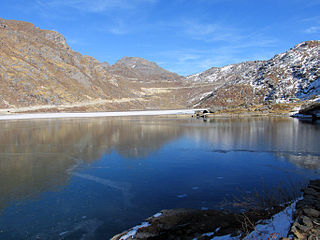
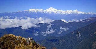
Dzuluk or Zuluk or Jhuluk or Jaluk is a small hamlet located at a height of 9,400 feet (2,900 m) on the rugged terrain of the lower Himalayas in Rongli Subdivision of Pakyong District, which lies in the Indian state Sikkim. This place is relatively an emerging and offbeat destination in Sikkim. Today it is a tourist destination for the view of the eastern Himalayan mountain range including the Kanchenjunga.
National Highway 717A, commonly referred to as NH 717A is a National Highway in India which is a part of the Bharatmala Pariyojana of Ministry of Road Transport and Highways, Government of India. NH 717-A starts from National Highway 17 at Bagrakote and ends in Gangtok. NH-717A traverses the states of West Bengal and Sikkim in India. It runs through two districts of West Bengal namely Jalpaiguri district, Kalimpong district and two districts of Sikkim, which are Pakyong District and Gangtok District. The highway is being constructed and maintained by the National Highways and Infrastructure Development Corporation Limited (NHIDCL).
Pakyongdistrict is a district in the Indian state of Sikkim, administered from Pakyong. The district was formed in 2021 from three former subdivisions of the East Sikkim district, viz., Pakyong Subdivision, Rangpo Subdivision and Rongli Subdivision. The remaining Gangtok Subdivision of the former district was named as the Gangtok district, which now bounds the Pakyong district in the northwest. In addition, the district is now bounded by the Kalimpong district of West Bengal, Bhutan, China and the Namchi district of Sikkim.


