Sherathang

Last updated

Sherathang
Town
Sherathang (7348765274).jpg
Sikkim location map.svg
Red pog.svg
Sherathang
Location in Sikkim, India
Coordinates: 27°23′N88°49′E / 27.383°N 88.817°E / 27.383; 88.817
CountryFlag of India.svg  India
State Sikkim
Languages
  Official Nepali, Lepcha, Limbu, Newari, Rai, Gurung, Bhutia, Mangar, Sherpa, Tamang and Sunwar
Time zone UTC+5:30 (IST)
PIN
737103
Vehicle registration SK
Lok Sabha Sikkim Constituency
Nearest city Gangtok
Vidhan Sabha Kabi Lungchok Constituency
Website eastsikkim.nic.in

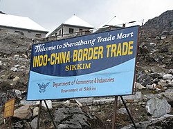
Sherathang is a town in Gangtok district near the Nathu La Pass in Sikkim, India. The location has been identified as the site for excise, customs and checking for trade between India and China. Rinqingang is the corresponding location in China.

Contents

Sherathang has an Indo-Tibetan Border Police border post, [1] which is one of the India-China Border Personnel Meeting point (BPM point). A regular scheduled international mail exchange between India Post and China takes place here twice a week. [1] There is a war memorial at Sherathang to commemorate the Indian Army's martyrs and war heroes of 1967 Nathu La and Cho La clashes. [2]

Border crossing

Sherathang in India and Rinchengang in Tibet are the designated India-China border trade marts for the local cross-border trade. In 2003, the governments of India and China agreed to use these locations as designated border trade mart. [3] [4] [5]

Sherathang border post is also a mail exchange point between India Post and China. On Indian side, the mail from mainland India is received at India Post’s Siliguri office, send to Indian Army's Upper Tadong-based 77 Field post office, "The mail, mostly letters are vetted and then sealed in a bag and a manifest issued for the Chinese post office at Yathung in Tibet’s Chumbi Valley is sent to the India Post’s Gangtok head office, from where the sealed bag is collected by the Sherathang postman. While the mail exchange on the Indian side of the border takes place every Sunday, the exchange on the Chinese side takes place every Thursday." [1]

Infrastructure

Power Department, Government of Sikkim has recently commissioned 2X5 MVA, 66/11KV, Sherathang sub-station in the presence of Mr Phigu T. Bhutia, Principal Chief Engineer and his team of other senior officers which is the highest altitude permanent power sub-station in India and second in the world at an altitude of 13,600 feet. The substation was installed as part of the Central Government’s ‘24×7 power for all’ initiative, which aims to meet the electricity needs to many far-flung corners of the country including the troops stationed at the border areas. Workers had to cope with the high altitude, low temperatures, lack of oxygen and intense ultraviolet rays. Geographical remoteness and extreme weather, frequent blizzards and wide-ranging temperatures – between -10 and 20 C in the summer – make managing a power station a herculean task.[ citation needed ]

Sherathang Trade Mart has the highest altitude permanent internet café in the world, at an altitude of 13,600 feet. It was added to the Limca Book of Records 2007. This internet café also doubles as a photographic studio, provides scanning and faxing facilities. Internet charges are at a nominal Rs. 20 per hour. Free training courses are also given here. The café was set up by the Community Information Centre (CIC) of the Sikkim Information Technology (IT) department and inaugurated by the Chief Secretary of the hill state, N.D. Chingapa, on 21 April 2006. It is frequented by students, traders, tourists and army personnel since it is just 8 km below the Nathu La Pass. [6]

See also

Related Research Articles

<span class="mw-page-title-main">Sikkim</span> State in northeastern India

Sikkim is a state in northeastern India. It borders the Tibet Autonomous Region of China in the north and northeast, Bhutan in the east, Koshi Province of Nepal in the west, and West Bengal in the south. Sikkim is also close to the Siliguri Corridor, which borders Bangladesh. Sikkim is the least populous and second-smallest among the Indian states. Situated in the Eastern Himalaya, Sikkim is notable for its biodiversity, including alpine and subtropical climates, as well as being a host to Kangchenjunga, the highest peak in India and third-highest on Earth. Sikkim's capital and largest city is Gangtok. Almost 35% of the state is covered by Khangchendzonga National Park – a UNESCO World Heritage Site.

<span class="mw-page-title-main">Kalimpong</span> Town in West Bengal, India

Kalimpong is a town and the headquarters of an eponymous district in the Indian state of West Bengal. It is located at an average elevation of 1,250 metres (4,101 ft). The town is the headquarters of the Kalimpong district. The region comes under Gorkhaland Territorial Administration which is an autonomous governing body within the state of West Bengal. The Indian Army's 27 Mountain Division is located on the outskirts of the city.

<span class="mw-page-title-main">Jelep La</span> Mountain pass between Sikkim, India and Tibet

Jelep La elevation 14,390 feet (4,390 m), is a high mountain pass between Sikkim, India and Tibet Autonomous Region, China. It is on a route that connects Lhasa to India. The pass is about 4 km (2.5 mi) south of Nathu La and is slightly higher. It was frequently used for trade between Tibet and India during the British Raj, with Kalimpong serving as the contact point. The Menmecho Lake lies below the Jelep La.

<span class="mw-page-title-main">Nathu La</span> Mountain pass in Sikkim, India

Nathu La(Tibetan: རྣ་ཐོས་ལ་, Wylie: Rna thos la, THL: Na tö la, Sikkimese: རྣ་ཐོས་ལ་) is a mountain pass in the Dongkya Range of the Himalayas between China's Yadong County in Tibet, and the Indian states of Sikkim. But minor touch of Bengal in South Asia. The pass, at 4,310 m (14,140 ft), connects the towns of Kalimpong and Gangtok to the villages and towns of the lower Chumbi Valley.

<span class="mw-page-title-main">Gangtok district</span> District in Sikkim, India

Gangtok District is an administrative district of the Indian state of Sikkim. It was renamed in 2021 as a result of administrative reorganisation of the state, which also saw three subdivisions of the East Sikkim district spawned off as a separate Pakyong district.

<span class="mw-page-title-main">Yadong County</span> County in Tibet, China

Yadong County, also known by its Tibetan name Dromo/TromoCounty is a frontier county and trade-market of the Tibet Autonomous Region of China, part of its Shigatse Prefecture.

<span class="mw-page-title-main">Chumbi Valley</span> Valley in Yadong County, Tibet, China

The Chumbi Valley, called Dromo or Tromo in Tibetan, is a valley in the Himalayas that projects southwards from the Tibetan plateau, intervening between Sikkim and Bhutan. It is coextensive with the administrative unit Yadong County in the Tibet Autonomous Region of China. The Chumbi Valley is connected to Sikkim to the southwest via the mountain passes of Nathu La and Jelep La.

<span class="mw-page-title-main">Nathu La and Cho La clashes</span> Border clashes between China and India in 1967

The Nathu La and Cho La clashes, sometimes referred to as Indo-China War of 1967, Sino-Indian War of 1967, were a series of border clashes between China and India alongside the border of the Himalayan Kingdom of Sikkim, then an Indian protectorate.

<span class="mw-page-title-main">Sino-Indian border dispute</span> Border dispute between China and India

The Sino–Indian border dispute is an ongoing territorial dispute over the sovereignty of two relatively large, and several smaller, separated pieces of territory between China and India. The first of the territories, Aksai Chin, is administered by China and claimed by India; it is mostly uninhabited high-altitude wasteland but with some significant pasture lands at the margins. It lies at the intersection of Kashmir, Tibet and Xinjiang, and is crossed by China's Xinjiang-Tibet Highway; the other disputed territory is south of the McMahon Line, in the area formerly known as the North-East Frontier Agency and now a state called Arunachal Pradesh. It is administered by India and claimed by China. The McMahon Line was signed between British India and Tibet to form part of the 1914 Simla Convention, but the latter was never ratified by China. China disowns the McMahon Line agreement, stating that Tibet was not independent when it signed the Simla Convention.

<span class="mw-page-title-main">Yatung</span> Town in Tibet, China

Yatung or Yadong, also known as Shasima , is the principal town in the Chumbi Valley or Yadong County in the Tibet Autonomous Region of China. It is also its administrative headquarters.

<span class="mw-page-title-main">Sikkim expedition</span> 1888 British military operation to expel Tibetan forces from Sikkim

The Sikkim expedition was an 1888 British military expedition to expel Tibetan forces from Sikkim. The roots of the conflict lay in British–Tibetan competition for suzerainty over Sikkim.

Cho La or Cho-la is a mountain pass in the Chola range of the Himalayas. It connects the Indian state of Sikkim with China's Tibet Autonomous Region. It is situated around four miles to the north-west of Nathu La.

<span class="mw-page-title-main">Doklam</span> Disputed area between China and Bhutan

Doklam, called Donglang by China, is an area in Bhutan with a high plateau and a valley, lying between China's Chumbi Valley to the north, Bhutan's Ha District to the east and India's Sikkim state to the west. It has been depicted as part of Bhutan in the Bhutanese maps since 1961, but it is also claimed by China. The dispute has not been resolved despite several rounds of border negotiations between Bhutan and China. The area is of strategic importance to all three countries.

<span class="mw-page-title-main">2017 China–India border standoff</span> Military dispute over road construction

The 2017 China–India border standoff or Doklam standoff was a military border standoff between the Indian Armed Forces and the People's Liberation Army of China over Chinese construction of a road in Doklam, near a trijunction border area known in Chinese as Donglang, or Donglang Caochang . On 16 June 2017 Chinese troops with construction vehicles and road-building equipment began extending an existing road southward in Doklam, a territory that is claimed by both China and India's ally Bhutan.

<span class="mw-page-title-main">Chumbi</span> Village in the Chumbi Valley of Tibet, China

Chumbi is a historic village in the Chumbi Valley or the Yadong County of the Tibet Autonomous Region of China. It is in the valley of the Amo Chu River, where the route from Sikkim's Cho La Pass meets the Amo Chu Valley. The "Chumbi Valley" of the European nomenclature derives its name from the village of Chumbi. It was the administrative center of the lower Chumbi Valley until the Chinese take-over of Tibet in 1950, after which Yatung became its headquarters. Chumbi is also associated with the Sikkim's royal family, which had a summer palace in the village.

The Five Fingers of Tibet was a Chinese territorial claim to the Himalayan region bordering India attributed to Mao Zedong. It considers Tibet to be China's right hand palm, with five fingers on its periphery: Ladakh, Nepal, Sikkim, Bhutan, and North-East Frontier Agency that are considered China's responsibility to "liberate". The policy however has never been discussed in official Chinese public statements and is now dormant, but concerns have often been raised over its possible continued existence or revival.

<span class="mw-page-title-main">Rinchengang</span> Town in Yadong, China

Rinchengang (Tibetan: རིན་ཆེན་སྒང, Wylie: rin chen sgang, THL: rin chen gang, ZYPY: Rinqêngang) or Renqinggang (Chinese: 仁青岗村; pinyin: Rén qīng gǎng cūn) is a town in the Chumbi Valley and the headquarters of the Xia Yadong Township of Yadong County, Tibet region of China. It is in the valley of Amo Chu where the route from Sikkim's Jelep La pass meets Amo Chu. It is also close to the Bhutan–China border, which is currently in dispute. In December 2018, Rinchengang village had a population of around 550 people. The inhabitants are engaged in animal grazing or work as forest rangers. Some also carry supplies to Chinese border troops.

<span class="mw-page-title-main">Old Yatung</span> Place in Tibet

Old Yatung, originally just "Yatung", with a native Tibetan spelling of Nyatong or Myatong, is a location 2 miles west of Rinchengang in the lower Chumbi Valley in the present day Yadong County of Tibet. It is in the valley of Yatung Chu, the river that flows down from Jelep La to join the Amo Chu river near Rinchengang. But according to travel writer John Easton, Yatung is actually a hill top location adjoining the valley, which has a historic Kagyu monastery. The monastery itself lies along the route from the Nathu La pass via Champithang.

<span class="mw-page-title-main">Chema, Tibet</span> Village in Yadong, China

Chema or Phema (Tibetan: བྱེ་མ, Wylie: bye ma, THL: jé ma, ZYPY: Qêma; Chinese: 切玛; pinyin: Qiè mǎ), is a village in the Chumbi Valley or Yadong County in the Tibet region of China. It is in the valley of Amo Chu where the route from Sikkim's Nathu La pass meets the Amo Chu valley. Chema is in the Xiayadong Township.

Kupup is a hamlet in the Indian state of Sikkim near the border with China. It lies in a transverse valley below the Dongkya Range, close to the Jelep La pass. A nearby moraine ridge across the valley forms part of the watershed between the Teesta and Dichu river basins. To the southeast of the ridge is the lake Bitang Tso, also called the Elephant Lake or Kupup Lake, from which the Dichu river is conventionally believed to originate.

References

  1. 1 2 3 You’ve got mail, at 14,000 ft: Sikkim man delivers letters between lndia, China, Hindustan Times, 23 April 2017.
  2. "53rd Anniversary of Sino-Indian Nathula skirmish: Wreath laid at Sherathang War Memorial". UNI. 11 September 2020. Retrieved 29 March 2021.
  3. Mathou 2004, note 39, p. 405.
  4. "Documents signed between India and China during Prime Minister Vajpayee's visit to China". Ministry of External Affairs, Government of India. 23 June 2003. Retrieved 27 March 2021.
  5. Roy, Esha (25 July 2017). "Next to flashpoint, home tension bigger headache than China chill". The Indian Express. Retrieved 28 March 2021.
  6. "Highest cyber cafe under snow". The Telegraph. 1 March 2007. Archived from the original on 3 March 2016. Retrieved 28 March 2021.

Bibliography