Gangtok District is an administrative district of the Indian state of Sikkim. It was renamed in 2021 as a result of administrative reorganisation of the state, which also saw three subdivisions of the East Sikkim district spawned off as a separate Pakyong district.
Gyalshing is a city, located in Gyalshing district, in the Indian state of Sikkim. It is administrative headquarter of district. The town is connected to the capital Gangtok by a metalled road. Geyzing is also connected to the West Bengal towns of Darjeeling and Kalimpong via Jorethang. A few kilometres north is the town of Pelling. The town has a large Nepali population, and the Nepali language is the predominant language of the region. The town is situated at an altitude of about 6,500 feet (1,900 m). The town enjoys a temperate climate for most of the year and snow sometimes falls in the vicinity.

Puthunagaram is a town and gram panchayat in the Palakkad district, state of Kerala, India. It is about 10 km south of Palakkad and 8 Km from Kollengode. Palakkad-Pollachi railway line passes through this town.

Birwadi is a census town in Raigad district in the state of Maharashtra, India.
Chinnasekkadu is a neighbourhood of Chennai in Chennai district in the state of Tamil Nadu, India. Chinnasekkadu used to be a town panchayat in Thiruvallur district. In 2011, the Chinnasekkadu town Panchayat was merged with Chennai Corporation. Chinnasekkadu comes under ward 29 in Zone 3 (Madhavaram) of Chennai Corporation.
Dhanuha is a census town in Jaunpur district in the state of Uttar Pradesh, India.
Ezhudesam is a town in Kanniyakumari district in the state of Tamil Nadu, India.

Kadipur is a town, tehsil and a nagar panchayat in Sultanpur district in the Indian state of Uttar Pradesh. It is located a short distance from the bank of the Gomti River, at a crossroads between two roads heading from Sultanpur to Surapur and from Pratapgarh to Dostpur and then on to Akbarpur. On the north side of town is a stream with a steep ravine that drains the surrounding area. The road to Sultanpur crosses over this stream on a bridge. The lands surrounding Kadipur are average quality for agricultural purposes. As of 2011, Kadipur has a population of 8,010 people, in 1,216 households.
Kumbhkot is a census town in Kota district in the Indian state of Rajasthan.
Mukhiguda is a census town in Kalahandi district in the Indian state of Odisha. Mukhiguda is one of the villages in Jayapatna tehsil. Mukhiguda is 7 km from its tehsil's main town, Jaipatna, is located 87 km from its district's main city, Bhawanipatna, and is located 510 km (320 mi) from its state's main city Bhubaneswar.
Purusottampur is a town and a Notified Area Council in Ganjam district in the Indian state of Odisha.

Singtam is a town which lies mostly in Gangtok District and partly in Pakyong District in the Indian state of Sikkim about 30 kilometres (19 mi) from the state capital Gangtok. The town lies on the banking of the rivers Teesta and Ranikhola, which join together just below the town. NH10 and NH510 meet in Singtam. The Indreni Bridge and Sherwani Bridge over the river Teesta are in the town. Singtam District Hospital, the district hospital of Pakyong District, lies at Golitar, Singtam.
Thevaram is a town in Theni district in the Indian state of Tamil Nadu. Thevaram is located in Tamil Nadu near the border of Kerala at the Eastern side foot-hill of the Western Ghats. It is connected with State Highway SH100.
Vengathur is a census town in Thiruvallur district in the Indian state of Tamil Nadu.
Jafarabad is a town and nagar panchayat in Jaunpur district in the Indian state of Uttar Pradesh.
Dhariwal is a fifth largest town and a municipal council in Gurdaspur district in the state of Punjab, India. Dhariwal was most famous for its woolen mill. This town is situated on the banks of river Upper Bari Duba and is 13 km away from Gurdaspur on the Gurdaspur-Batala highway. Dhariwal, like the rest of north-western India, features a humid subtropical climate. Average yearly precipitation is about 925mm, 70% of it receives during monsoon season (June-September). Winter is also wet. June is the hottest while January is coldest month. In winter, dense fog persists for three to five days. As a result, day temperature drops to single digits. During May and June, dust storms followed by intense spells for short intervals are not uncommon. Monsoon arrives in the end of June and withdrawal starts around the third week of September. The town is prone to heatwaves during summer and chills during winter.
Kerur is a town in Bagalkot district in Karnataka, which located on NH 218. It has an average elevation of 617 meters (2024 feet). It's the birthplace of Jagadish Shettar, a former chief minister of Karnataka. Kerur is a Town Panchayat city in the district of Bagalkot, Karnataka. The Kerur city is divided into 16 wards for which elections are held every five years. The Kerur Town Panchayat has a population of 19,731 of which 9,929 are males while 9,802 are females as per report released by Census India 2011.

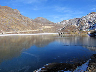
Mangan is a town and the headquarter of the district of Mangan District in the Indian state of Sikkim. The town lying near River Teesta is connected to the capital Gangtok by a metalled road. Mangan District is the largest district of Sikkim in terms of area. The town lies in the geographic south of the district. After the opening up of the district, Mangan has witnessed a spurt in its economy, mostly due to organic farming. The town opens up the Tibetan Plateau. Mangan also serves the towns of Lachung, Chungthang and Lachen in the far north. Owing to its elevation, the town enjoys a temperate climate.
Tareythang is a village located in Pakyong sub division at the Pakyong District of Sikkim state in India. This village is about 1250 m above sea level with a sub-tropical climate. It is around 10 kilometers away from district headquarter Pakyong. In electoral roll of 2011, Tareythang comes under the Assembly Constituency of Chujachen.
Chadiapada is a small village in Ganjam district of Odisha, India.

