Gangtok district[2] is an administrative district of the Indianstate of Sikkim. It was renamed in 2021 as a result of administrative reorganisation of the state, which also saw three subdivisions of the East Sikkim district spawned off as a separate Pakyong district.[3]
The headquarters of the Gangtok district is Gangtok, which is also the state capital. Gangtok is the hub of all administrative activity in the state. The district is bounded by the Pakyong district in the south and southeast, Bhutan in the east, the People's Republic of China in the northeast, Mangan District in the north and Namchi District in the west.
The civilian region is administered by a district collector, appointed by the state government. A major general is assigned to administer military forces in the district. As of 2011 it is the most populous of the six districts of Sikkim.[4]
History
East Sikkim was part of the Kingdom of Sikkim for most of its history. In the 19th century, the district was under the rule of the Bhutanese. After the Anglo Bhutan War, the territory was virtually under the command of the British forces. After India's independence in 1947, the area was part of the Kingdom of Sikkim under the protection of India. During the Sino-Indian War of 1962, the Nathula Pass witnessed a few skirmishes between India and China. In 1975, Sikkim formally became part of the Indian Union as India's 22nd state. The district was under the occupation of the Nepalese for 30 years in the eighteenth and nineteenth centuries.
Geography
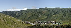
View of Kanchenjunga from Gangtok
The district occupies an area of 560km2 (220sqmi).
The two important Mountain Passes of East Sikkim are Nathula and Jelepla, both passes connects Sikkim with China.
Military-wise, the district is a very sensitive area with the Indian army having control over most areas east of Gangtok and near its borders with People's Republic of China and Bhutan. Visitors to this region are restricted and just a few areas are open to tourists in the areas east of Gangtok.
Popular tourist locales of East Sikkim and Pakyong districts are the Tsongmo Lake, Lake Menmecho, Dzuluk, Baba Mandir, Gnathang Valley, Elephant Lake Kupup, Lungthung View Point, Tukla Valley, Thambi View Point and the Nathu La pass. The pass was first opened during the 1904 Younghusband Expedition to Tibet.[5] It saw a tremendous boom in trade during 1950–1959 when the Chinese troops occupying Tibet were supplied through the pass.[6] The pass and Baba Mandir are open to Indian nationals only. To enter this region a special permit is required; the Inner Line Permit has to be obtained one day prior to departure. This permit is made through local tourist offices. Other tourist areas include the town of Gangtok, the Phodong Monastery north of Gangtok and the Rumtek Monastery.
Other special attractions in the Capital City Gangtok are M G Marg, Hanuman Tok, Ranka Monastery, Himalayan Zoological Park, Palzor Stadium, Tashi View Point, Pakyong Airport view Point. Zuluk And Gnathang Valley are famous attractions in East Sikkim.
According to the 2011 census East Sikkim district along with Pakyong District has a population of 283,583,[4] roughly equal to the nation of Barbados.[9] This gives it a ranking of 574th in India (out of a total of 640).[4] The district has a population density of 295 inhabitants per square kilometre (760/sqmi) .[4] Its population growth rate over the decade 2001-2011 was 14.79%.[4] East Sikkim has a sex ratio of 872 females for every 1000 males,[4] and a literacy rate of 84.67%.[4]
Hinduism is followed by majority of the people in the Gangtok district. Buddhism followed by a considerable minority, while Christianity is the third largest religion, 40% of its adherents live in Gangtok. Islam is the fourth-largest religion and is mainly found in migrants in urban centres, mainly Gangtok.[10]
East Sikkim is divided into three sub-divisions till June 2021. In June 2021, the two subdivisions of Pakyong and Rongli were constituted as Pakyong District:[12]
Important towns and cities
Gangtok at night
The major towns and cities of Gangtok District are
↑Sikkim Administrative Divisions(PDF) (Map). The Registrar General & Census Commissioner, India, New Delhi, Ministry of Home Affairs, Government of India. 2011. Retrieved 29 September 2011.
This page is based on this Wikipedia article Text is available under the CC BY-SA 4.0 license; additional terms may apply. Images, videos and audio are available under their respective licenses.