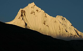
Gyalshing is a city, located in Gyalshing district, in the Indian state of Sikkim. It is administrative headquarter of district. The town is connected to the capital Gangtok by a metalled road. Geyzing is also connected to the West Bengal towns of Darjeeling and Kalimpong via Jorethang. A few kilometres north is the town of Pelling. The town has a large Nepali population, and the Nepali language is the predominant language of the region. The town is situated at an altitude of about 6,500 feet (1,900 m). The town enjoys a temperate climate for most of the year and snow sometimes falls in the vicinity.

Gyalshing District or Geyzing District is a district of the Indian state of Sikkim. Its headquarter is Geyzing, also known as Gyalshing. The district is a favourite with trekkers due to the high elevations. Other important towns include Pelling and Yuksom. Local people also call it as Pallo-Sikkim and Sano-Sikkim commonly.
North Sikkim is a district of the Indian state of Sikkim. Its district headquarters is Mangan. It is the seventh least populous district in the country.

Namchi District is a district of the Indian state of Sikkim. Its headquarters is at Namchi.

West Tripura is an administrative district in the state of Tripura in India. The district headquarters are located at Agartala. As of 2012 it is the most populous district of Tripura.

Darjeeling District is the northernmost district of the state of West Bengal in eastern India in the foothills of the Himalayas. The district is famous for its hill station and Darjeeling tea. Darjeeling is the district headquarters. Kurseong, Siliguri and Mirik, three major towns in the district, are the subdivisional headquarters of the district. Kalimpong was one of the subdivisions but on 14 February 2017, it officially became a separate Kalimpong district.

Bulandshahr district is a district in the Meerut region in the north Indian state of Uttar Pradesh (UP), situated between the Ganga and Yamuna rivers. It is a part of the National Capital Region of India, and Bulandshahr is the district headquarters.
Hathras district is a district of Uttar Pradesh state of India. The city of Hathras is the district headquarters. Hathras district is a part of Aligarh division. The district occupies an area of 1,840 square kilometres (710 sq mi) and has a population of 1,564,708 as of the 2011 census.

Shravasti district is one of the districts of the Uttar Pradesh state of India, with Bhinga town as its district headquarters. Shravasti district is a part of Devipatan Division. According to Government of India, it is among the 121 minority concentrated districts in India. It is the fourth most backward district in India, according to the 2018 Niti Aayog ranking. This district is the most poverty stricken district in the country.

Durg district is a district situated in Chhattisgarh, India. The district headquarters is Durg. The district covers an area of 2,238 km². As of 2011 it is the second most populous district of Chhattisgarh, after Raipur.

North Delhi is an administrative district of the National Capital Territory of Delhi in India. Alipur is the administrative headquarters of this district. North Delhi is bounded by the Yamuna River and the district of Central Delhi on the east and by the district of North West Delhi to the west.
North West Delhi is an administrative district of the National Capital Territory of Delhi in India.

Akole taluka is a taluka in Ahmednagar district in Maharashtra state of India. Akole consists of many places like Harishchandragad, Kalsubai, Bhandardara (Wilson) Dam, Sandhan Valley, Vishramgad etc. which attract tourists. Akole is not only famous for its natural scenery but, many historical events are also associated with it. The Western Akole is a part of Sahyadri ranges which increase its important.
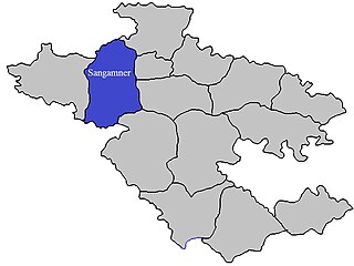
Sangamner taluka, is a taluka in Sangamner subdivision of Ahmednagar district in Maharashtra state of India.

Shrigonda Taluka, is a taluka in Karjat subdivision of Ahmednagar District in Maharashtra state of India. Its administrative headquarters is the town of Shrigonda.

Indapur taluka is a taluka in Baramati subdivision of Pune district of state of Maharashtra in India.

Purandar taluka is a taluka of Pune district of state of Maharashtra in India. There are 108 villages and 3 towns in Purandhar Taluka.

Velhe Taluka, officially renamed as, Rajgad Taluka, is a taluka in Haveli subdivision of Pune district of state of Maharashtra in India. The Taluka is entirely rural, and consists of 130 villages.

Sipahijala District is a district of Tripura, India. This district was created in January 2012 when four new districts were established in Tripura, taking the number of districts in the state from four to eight. Part of the district was formed from the former district of West Tripura. The principal towns in the district are Bishalgarh, Bishramganj, Melaghar and Sonamura.

Sarangarh-Bilaigarh district is one of the four new district in the state of Chhattisgarh, India announced by Bhupesh Baghel on 15 August 2021. It is carved out from Raigarh and Baloda Bazar districts.
