

This article lists the heads of government of the Kingdom of Sikkim from 1944 to 1975, when Sikkim became the 22nd state of India following a referendum. [1]
This article lists the heads of government of the Kingdom of Sikkim from 1944 to 1975, when Sikkim became the 22nd state of India following a referendum. [1]
(Dates in italics indicate de facto continuation of office)
| No. | Portrait | Name | Term | Notes |
|---|---|---|---|---|
| President of the State Council | ||||
| 1 | 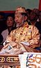 | Palden Thondup Namgyal | 1944–1949 | Later reigned as the twelfth and last Chogyal, in 1963–1975. |
| Chief Minister | ||||
| 2 | Tashi Tshering | 9 May 1949 – 6 June 1949 | ||
| 3 | Harishwar Dayal | 6 June 1949 – 11 August 1949 | Interim | |
| Dewan | ||||
| 4 | John S. Lall | 11 August 1949 – 1954 | ||
| 5 | Nari Kaikhosru Rustomji | 1954–1959 | ||
| 6 | Baleshwar Prasad | 22 August 1959 – 1963 | ||
| Principal Administrative Officer | ||||
| 7 | Ramdas Narayan Haldipur | 1963–1969 | ||
| Sidlon | ||||
| 8 | Inder Sen Chopra | 1969 – July 1972 | ||
| Chief Administrative Officer | ||||
| 9 | Brajbir Saran Das | 9 April 1973 – 23 July 1974 | ||
| Prime Minister | ||||
| 10 |  | Kazi Lhendup Dorjee | 23 July 1974 – 16 May 1975 | Afterwards served as the first Chief Minister of Sikkim, in 1975–1979. [2] |
| State symbols | |
|---|---|
| Topics | |
| Administration | |
| Districts | |
| Towns | |
| Rivers | |
| Lakes | |
| Glaciers | |
| See also | |