Pakyong district | |
|---|---|
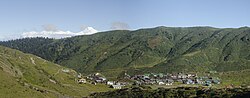
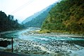
 Mt. Kangchenjunga view from Thambi View Point, Dzuluk, Pakyong District Sikkim. | |
 Pakyong district Location in Sikkim | |
| Coordinates: 27°23′N88°59′E / 27.383°N 88.983°E | |
| Country | |
| Headquarters | Pakyong |
| Government | |
| • District magistrate | Mr. Agawane Rohan Ramesh [1] |
| • Lok Sabha constituencies | Sikkim Constituency |
| • Vidhan Sabha constituencies | |
| Area | |
• Total | 404 km2 (156 sq mi) |
| Elevation | 1,120 m (3,670 ft) |
| Population (2011) | |
• Total | 74,583 |
| • Density | 185/km2 (478/sq mi) |
| Time zone | UTC+05:30 (IST) |
| ISO 3166 code | IN-SK |
| Vehicle registration | SK-07 |
| Major Highways | |
| Longest Bridge | |
| Largest Stadium | |
| Largest Wildlife Sanctuary | |
| Website | |
Pakyongdistrict is a district in the Indian state of Sikkim, administered from Pakyong. [2] The district was formed in 2021 from three former subdivisions of the East Sikkim district, viz., Pakyong Subdivision, Rangpo Subdivision and Rongli Subdivision. [3] The remaining Gangtok Subdivision of the former district was named as the Gangtok district, which now bounds the Pakyong district in the northwest. In addition, the district is now bounded by the Kalimpong district of West Bengal, Bhutan, China and the Namchi district of Sikkim.