
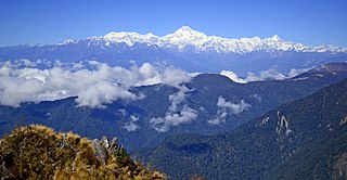
Sikkim is a state in northeastern India. It borders the Tibet Autonomous Region of China in the north and northeast, Bhutan in the east, Koshi Province of Nepal in the west, and West Bengal in the south. Sikkim is also close to the Siliguri Corridor, which borders Bangladesh. Sikkim is the least populous and second-smallest among the Indian states. Situated in the Eastern Himalaya, Sikkim is notable for its biodiversity, including alpine and subtropical climates, as well as being a host to Kangchenjunga, the highest peak in India and third-highest on Earth. Sikkim's capital and largest city is Gangtok. Almost 35% of the state is covered by Khangchendzonga National Park – a UNESCO World Heritage Site.
Mayiladuthurai is a special grade municipality and district headquarters of Mayiladuthurai district in Tamil Nadu, India. The town is located at a distance of 256 km (159 mi) from the state capital, Chennai.
Gyalshing is a city, located in Gyalshing district, in the Indian state of Sikkim. It is administrative headquarter of district. The town is connected to the capital Gangtok by a metalled road. Geyzing is also connected to the West Bengal towns of Darjeeling and Kalimpong via Jorethang. A few kilometres north is the town of Pelling. The town has a large Nepali population, and the Nepali language is the predominant language of the region. The town is situated at an altitude of about 6,500 feet (1,900 m). The town enjoys a temperate climate for most of the year and snow sometimes falls in the vicinity.
North Sikkim is a district of the Indian state of Sikkim. Its district headquarters is Mangan. It is the seventh least populous district in the country.

Pasighat is the headquarters of East Siang district in the Indian state of Arunachal Pradesh. Situated at the eastern foothills of the Himalayas at 155 metres (509 ft) above mean sea level, Pasighat is Arunachal's oldest town. The Government of India included Pasighat in the Smart Cities Mission development scheme in June 2017.
Tumlong is a village in the Indian state of Sikkim in northeastern India. It is located in the Mangan sub division of North Sikkim district. it is on the bank of the Dik Chu river, a tributary of the Teesta River.

Chungthang is a town in Mangan district in the Indian state of Sikkim. It is located just 28 km from Mangan town, the district headquarters. It is situated at the confluence of the Lachen and Lachung rivers, which combine to form the Teesta River. Located at a distance of 95 kilometres (59 mi) from the state capital Gangtok, the Indian Army has a major forward base with a medical centre in Chungthang.
Chirgaon is a town and a municipal board in Jhansi district in the Indian state of Uttar Pradesh, India.

Error: no page names specified (help).
Melagaram is a panchayat town in Tenkasi district, in the Indian state of Tamil Nadu. The Famous Composer Thirigudarasapa Kavirayar was born in Melagaram. Thirutrala Kuravanji is a classic Tamil language poem composed by Thirigudarasapa Kavirayar around 1600 - 1700 CE.

Nannilam is a Town and Taluk in Thiruvarur District in the Indian state of Tamil Nadu. It is the headquarters town for Nannilam Taluk.

Darjeeling Pulbazar is a community development block that forms an administrative division in the Darjeeling Sadar subdivision of the Darjeeling district in the Indian state of West Bengal.

Rangli Rangliot is a community development block that forms an administrative division in the Darjeeling Sadar subdivision of the Darjeeling district in the Indian state of West Bengal.
Kalimpong I is a community development block that forms an administrative division in the Kalimpong subdivision of the Kalimpong district in the Indian state of West Bengal.

Mangan is a town and the headquarter of the district of Mangan District in the Indian state of Sikkim. The town lying near River Teesta is connected to the capital Gangtok by a metalled road. Mangan District is the largest district of Sikkim in terms of area. The town lies in the geographic south of the district. After the opening up of the district, Mangan has witnessed a spurt in its economy, mostly due to organic farming. The town opens up the Tibetan Plateau. Mangan also serves the towns of Lachung, Chungthang and Lachen in the far north. Owing to its elevation, the town enjoys a temperate climate.
Rorathang is a town situated in the bank of Rangpo River on National Highway-717A, in Pakyong District of Sikkim, India.
Government Senior Secondary School, Central Pendam is a government, co-educational, English-medium school situated at Central Pendam in Pakyong District of Sikkim, India. It was established in 1942. The school prepares students for AISSE and AISSCE for science, commerce, humanities, IT application and financial marketing and management. The school currently runs from pre-primary to standard XII.
Tareythang is a village located in Pakyong sub division at the Pakyong District of Sikkim state in India. This village is about 1250 m above sea level with a sub-tropical climate. It is around 10 kilometers away from district headquarter Pakyong. In electoral roll of 2011, Tareythang comes under the Assembly Constituency of Chujachen.
Apra, also known as The Golden City Apra, is a census town in Phillaur Tehsil in Jalandhar district of Punjab State, India. The town is known for gold jewelry and paddy crops which are produced in large amounts. It is located 46 kilometres (29 mi) towards East from Jalandhar, 12 kilometres (7.5 mi) from Phillaur and 110 kilometres (68 mi) from Chandigarh. Apra is the largest town as compared to other surrounding villages and has the main marketplace. The town is administrated by Sarpanch an elected representative of the village.
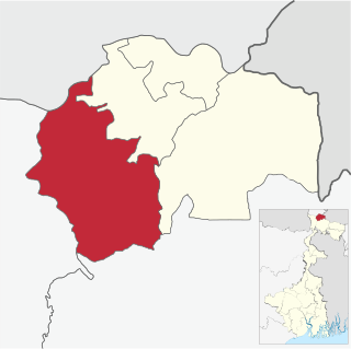
Pakyongdistrict is a district in the Indian state of Sikkim, administered from Pakyong. The district was formed in 2021 from three former subdivisions of the East Sikkim district, viz., Pakyong Subdivision, Rangpo Subdivision and Rongli Subdivision. The remaining Gangtok Subdivision of the former district was named as the Gangtok district, which now bounds the Pakyong district in the northwest. In addition, the district is now bounded by the Kalimpong district of West Bengal, Bhutan, China and the Namchi district of Sikkim.
