
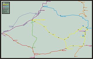
The Konkan Railway is one of the 19 railway zones in India with its headquarters at CBD Belapur in Navi Mumbai, Maharashtra, India. The first passenger train ran on Konkan railway tracks on 20 March 1993, between Udupi and Mangalore. During its initial years of operation in the mountainous Konkan region, a number of accidents prompted Konkan Railway to implement new technology. Anti-collision devices, the Sky Bus and roll-on/roll-off are several of the railway's innovations. The 756.25 km (469.91 mi) long railway line connects the states of Maharashtra, Goa and Karnataka. The first train on the completed track was sent off on 26 January 1998.

Central Railway is one of the 19 zones of Indian Railways. Its headquarters is in Mumbai at Chhatrapati Shivaji Maharaj Terminus. It has the distinction of operating the first passenger railway line in India, which opened from Mumbai to Thane on 16 April 1853.

Lonavala-Khandala is a hill station and a Municipal Council in the Pune district, Maharashtra, India. It is about 64 km west of Pune and 96 km to the east of Mumbai. It is known for its production of the hard candy chikki and is also a major stop on the railway line connecting Mumbai and Pune. From the Pune suburbs, local trains are available from Pune Junction. The Mumbai-Pune Expressway and the Mumbai-Bengaluru highway both pass through Lonavala.

Roha is a town and taluka in the Raigad district of the Maharashtra state of India. It is located 120 km southeast of Mumbai. It is the starting point of Konkan railways and end point of central railways (Mumbai). Many chemical industries have opened up their manufacturing bases in Roha. Roha is located between the banks of the Kundalika River and the hills of Kalasgiri. It has a population of over 20,849. Roha is connected to Mumbai by Panvel-Roha railway line. Roha is also the northern end of the Konkan Railway. Roha is off of the Mumbai Goa Highway, via the Kolad road.[[From year 2023 Mr surendra Nimbalkar and his wife miss Swapnali Nimbalkar started mega movement ,ROHA CITY OF FLOWERS ,Roha Roha Is Suround with buitifull neture ,clean and nit river,dense forest,flowering trees and pleasant atomsphire and taluka, and, nimbalkar couple decide to transform city in to beutiful flower city to attract tourists and develope agro tourism as well as forest tourism, and, roha is geographical ideal place to grow city as a tourist place because india two metro city Mumbai and Pune very close to roha city only 2 hrs journey surendra nimbalkar stared to conect all Roha based NGO To run this drive speedily, also all roha citizens support him for this drive ,he started his first destination from kalasgiri hill as he discovered and regenerate old lake for using water for tree plantetion as well as for wild animal water source]]
Panvel is a city and taluka in Raigad district of Maharashtra, India. It is highly populated due to its closeness to Mumbai. Panvel is also governed for development purpose by the body of Mumbai Metropolitan Region. Panvel Municipal Corporation is the first Municipal Corporation in Raigad and the 27th Municipal corporation of Maharashtra State.

Konkan Railway Corporation Limited (KRCL) is an Indian public sector undertaking which operates Konkan Railway and also undertakes other railway-related projects. It is wholly-owned by the Government of India under the administrative control of the Ministry of Railways and headquartered at CBD Belapur in Navi Mumbai. The railway (railroad) route of KRCL covers the coastal districts of Maharashtra, Goa and Karnataka states of India.
Kamshet is a region located in Pune district in the state of Maharashtra, India, 110 km from Mumbai City, and 45 km from Pune in Pune district. It is 16 km from the twin hill stations of Khandala and Lonavala and is accessible by road and rail from Mumbai (Bombay) and Pune. Kamshet is home to small villages that are built in the traditional style - with mud, thatch and reeds.

The Kundalika is a small river flowing from the hills of Sahyadri to the Arabian Sea. This river originates at a small town called Bhira in the Indian state of Maharashtra, 150 km south east of Bombay (Mumbai). The important towns located on the banks of Kundalika are Kolad, Korlai, Chaul, Roha and Salav.

Mahad ( [məɦaːɖ]) is a city in Raigad district situated in the North Konkan region of Maharashtra state, India. It is located 108.5 km (67.4 mi) from District Headquarters Alibag, and 167 km (104 mi) from Mumbai. Mahad is known for Raigad Fort, the capital of the Maratha Empire in Shivaji Maharaj's era and the revolutionary Mahad Satyagraha launched by at Chavdar Tale in the wake of modern India.

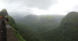
Ghat Roads are access routes into the mountainous Western and Eastern Ghats, mountain ranges of the Indian subcontinent. These roads are remarkable feats of engineering, and most were constructed during the British Raj. Ghat Roads were built to connect to the hill stations established in the mountains for residents to avoid summer heat. They generally served to connect coastal areas with the upper Deccan Plateau.
Sangameshwar Taluka is a taluka in Ratnagiri subdivision of Ratnagiri district in the Indian state of Maharashtra. The headquarters for the taluka is the town of Devrukh. In Sangameshwar the two rivers Sonavi and Shastri flow together. The meaning of Sangama in Marathi is "confluence," and so the name "Sangameshwar". It is historically important as the place where Chhatrapati Sambhaji, son of Chhatrapati Shivaji was captured by Mughal Emperor Aurangzeb. Chhatrapati Sambhaji was tortured and executed in Tulapur.

The Western Coastal Plains is a narrow stretch of landmass lying between the western part of the Deccan plateau and the Arabian in India. The plains stretch from the Kutch region to Kaniyakumari at the southern tip of the Indian peninsula with the Western Ghats forming its eastern boundary. It traverses the states of Gujarat, Maharashtra, Goa, Karnataka, and Kerala.
Kolad is a village in Raigad district, Maharashtra State, India. It is 117 km from Mumbai on the National Highway no 66(Mumbai-Goa) its also connected to Pune via Kolad Pune- Kolad state highway. It lies on the banks of River Kundalika. The village post office Postal Index Number is 402304 & 402109.
Mangalore's location in the Indian state of Karnataka makes it accessible by all forms of transport: road, rail, air and sea. It is the largest city in the Coastal Karnataka region, and is the only city in Karnataka and one among the six cities in India to have an International Airport, a Major Seaport, railway & road connectivities. It is the second prominent city of Karnataka after the state capital Bangalore in all aspects. It is one of the fastest developing cities in India.
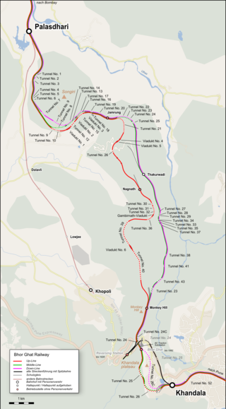
Bhor Ghat is a mountain pass located between Palasdari and Khandala for railway and between Khopoli and Khandala on the road route in Maharashtra, India, on the crest of the Western Ghats.
Kurli is a village in Sindhudurg District, the south easternmost district of Konkan Division, Maharashtra, India. Kurli is located 7.9 km from its Taluk Main Town Vaibhavwadi. Kurli is 33.6 km from its District main city, Oras. It is 307 km from its State Main City Mumbai. This is a culturally and historically important village. Kurli consists of wadis like Temb Wadi, Khadakwadi, Bajarpeth. Also, it is famous because of the newly made Kurli dam.

Katraj Ghat is a mountain pass located on the southern outskirts of the city of Pune in Maharashtra, India. A New Katraj Tunnel new tunnel of 6 lanes is constructed to bypass this ghat.
Varandha Ghat is a mountain passage located between NH4 and Konkan in Maharashtra, India for road traffic. Situated on the crest of the Western Ghat mountain ranges, Varandha Ghat is noted for its surroundings, comprising scenic waterfalls, lakes and dense woods.
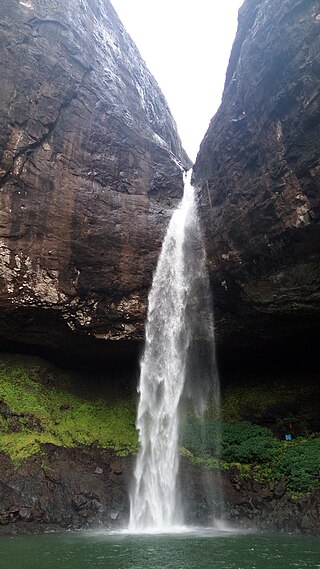
Devkund Waterfall is a waterfall located near Bhira, in Raigad district, Maharashtra, India. It is a 'plunge' waterfall pouring massive amounts of water on the rocky surface underneath. It is a popular spot for one day picnics.
Indapur is a village located on the Mumbai-Goa Highway in India. Indapur comes under the Mangaon taluka of Raigad district. Talashet is the gram panchayat of Indapur village. The sub-district headquarter Mangaon is 10 km away and district headquarter Alibag is 73 km away.
