Narayangaon

Last updated

Narayangaon
Town
GMRT antenna at sunset.jpg
Giant Metrewave Radio Telescope (GMRT) near Narayangaon
India Maharashtra location map.svg
Red pog.svg
Narayangaon
Location in Maharashtra, India
Coordinates: 19°07′00″N73°55′00″E / 19.11667°N 73.91667°E / 19.11667; 73.91667
CountryFlag of India.svg  India
State Maharashtra
District Pune
Taluka Junnar
  Rankwarulwadi
Elevation
656 m (2,152 ft)
Languages
  Official Marathi
Time zone UTC+5:30 (IST)
PIN
410504
Telephone code91-2132-XXXXXX
Vehicle registration MH-14

Narayangaon is a town in the Junnar taluka of the Pune district of Maharashtra state, India. Water is abundant because of its proximity to the major dams, the western ghats, and the Sahyadri mountain range.

Contents

Geography

Narayangaon is located 656 m (2,152 ft) above sea level on the western margin of the Deccan plateau. It is situated on the leeward side of the Sahyadri mountain range, which forms a barrier from the Arabian sea. Narayangaon is on the bank of the river Meena. A wide hill range in the south separates the town from the adjoining Ambegaon taluka.

Narayangaon can be reached from major cities via road. It is situated on Pune-Nasik National Highway 50. It is 77 km north of Pune, 132 km south of Nasik and around 176 km east of the state capital, Mumbai.

Historic importance

Shivneri Fort, the birthplace of Chattrapati Shivaji Maharaj, who founded and ruled the Maratha empire during the 17th century, is 16 km away from Narayangaon. Two of the Ashtavinayak Ganapati, Lenyadri and Ozar, are located nearby. Historical Nane ghat is a place from where trading to the Mumbai market was being done since around 8th century. It is around 35 km west of Narayangaon. Lenyadri, Manmodi, Tulja, Shivneri are the caves in nearby areas which have existed since the Buddhist era.Narayangaon is also Famous For Maharashtrian folk Dance Lavani.all Tamasha Mandals(Teams) Starts Their New season of performances from Narayangaon.an alternative Name For Narayangaon is "Tamasha Pandhari".

Tourism

View of Malshej hills Malshej Hills.jpg
View of Malshej hills

Junnar taluka is noted for the presence of 27 leopards in a 500sq m area. The leopard rehabilitation center in Manikdoh, around 25 km west of Narayangaon, is becoming a tourist attraction ever since its establishment.[ citation needed ] Malshej Ghat, a tourist destination in the western ghats, is a 45-minute drive away.

A number of commercials and films have used Narayangaon as a backdrop.[ citation needed ] Visitors explore the architectures of medieval periods such as Adilshahi in nearby places.[ citation needed ] Caves, dams in nearby areas can also be explored by tourists.

Forts

Chhatrapati Shivaji Maharaj was born at Shivneri Fort, 16 km west of Narayangaon. Shivneri fort is one of the most noted historic places in Maharashtra (India).[ citation needed ]

The Narayangad fort is about 8 km north-east of Narayangaon, and is believed to be the origin of the town's name.

Ganpirbaba, Chawnd, Nimgiri, Dhakoba, Hadsar, Jivdhan, Harishchandra are other important forts nearby, some of which have become great attractions for trekking. Nature lovers can visit these forts for the natural environment and the rare species of plants found nearby.[ citation needed ]

Temples

Goddess 'Muktabai' (Muktaai) (मुक्ताबाई\मुक्ताई) is the Gram-Daivat (root deity) of Narayangaon. Muktabai Temple is situated on the bank of Meena river. It has recently undergone major renovation.[ when? ]

The yatra of Goddess Muktaai starts after the day of 'Varuthini, Ekadashi. This is one of the biggest yatra in Maharashtra state. People come from different parts of the state to enjoy this festival.

Lord Ram temple was established in the era of Peshwas. It is situated at the centre of town. The temple was given to the Brahman Sangh in the 1990s. It was later renovated. The festival of Ramnavami is celebrated every year in the temple.

Hanuman temple is one of the oldest in town.

Shambhu Mahadev temple is a branch of Shikhar Shingnapur Mahadev temple. The khandoba temple near Abhinandan Collection is believed to be Thaan of Naldurga Khandoba situated at Naldurga in Osmanabad district.

Two of the Ashtavinayak Ganapatis are located nearby:

Also a Lord Shiva temple named 'Kapardikeshwar' is in Otur, 15 km north to the Narayangaon. Lord Khandoba temple is situated near Wadaj, 12 km west from the town.

Farming

As the town is surrounded by dams and the western ghats, and Shyadri mountain range is in its proximity, water is abundant in Narayangaon and surrounding places. Farming is a major income source here, and mainly includes vegetables and sugar canes. In the last few years,[ when? ] farmers here are also trying for other sources of income. Narayangaon has emerged as a major export place of table grapes. Grapes from here are exported mainly to the Middle East and Europe.

Tomato market

At the Narayangaon market, the trader or his representative comes to the farmer and quotes a price. No middlemen involved and the deal is struck. The farmer gets his money right on the spot.[ citation needed ]

The turnover of the tomato market has increased from Rs 3 crore in 2004 to more than Rs 150 crore in 2013. [1] 600–700 farmer groups of 20 people who work on supply of tomatoes to Pune, Ahmednagar, Thane and Raigad. [2] Around 200 truckloads of tomatoes also go to the North every day. [3] Due to its specific climatic conditions, Narayangaon supplies more than 60% of tomatoes consumed in the country during the four months of the rainy season. [4]

Proximity to dams

Narayangaon is close to the five major dams. The nearest is Yedgaon Dam on the Kukadi river, about 9 km to the north. Wadaj Dam on the river Meena is 16 km to the west. Pimpalgaon Joge Dam on Pushpavati is 30 km to the northwest, and Manikdoh Dam on the river Kukadi, is 25 km to the northwest. Chilewadi Dam on the river Mandvi, is 25 km to the north.

Science

The Giant Metrewave Radio Telescope is located 9 km to the east. It is the world's largest array of radio telescopes at metre wavelengths. It is operated by the National Centre for Radio Astrophysics, a part of the Tata Institute of Fundamental Research, Mumbai.

VSNL's (Videsh Sanchar Nigam Ltd.) major project is located at Arvi, 5 km away from the town.

Narayangaon yatraotsav

Narayangaon is considered to be the center for the performing folk art tamasha. Narayangaon yatraotsav (Narayangaon fair) is the largest trade fair dedicated to it. Troupes from all over Maharashtra congregate to the fare during which performances are booked by patrons by payment of advances. Sant Sahadubaba Bhau Waykar, famously known as Chakankar Baba hails from Narayangaon's Gunjalwadi. [5]

Famous Narayangaon People's

Amol Kolhe
Vithabai Bhau Mang Narayangaonkar
Mangala Bansode

Related Research Articles

<span class="mw-page-title-main">Shivneri Fort</span> Fort in Maharashtra, India

Shivneri Fort is an ancient military fortification located near Junnar in Pune district in Maharashtra, India. It is the birthplace of Shivaji, the founder of Maratha Empire.

<span class="mw-page-title-main">Ashtavinayaka</span> Pilgrimage to eight Hindu temples in Maharashtra, India

Ashtavinayaka is a Sanskrit term which means "eight Ganeshas". The Ashtavinayaka Yatra refers to a pilgrimage to the eight Hindu temples in the state of Maharashtra, India, centered around the city of Pune. The eight temples house eight distinct idols of Ganesha, the Hindu deity of unity, prosperity, learning, and removing obstacles. Each of these temples has its own individual legend and history, as distinct from each other as the murtis in each temple. The form of each murti of Ganesha and his trunk are distinct from one another. There are other temples of eight Ganesha in various other parts of Maharashtra; however, the ones around Pune are more well known and visited. To complete the Ashtavinayaka Yatra, one must revisit the first temple after visiting all the eight temples.

<span class="mw-page-title-main">Bhima River</span> Major river in southwest India

The Bhima River is a major river in Western India and South India. It flows southeast for 861 kilometres (535 mi) through Maharashtra, Karnataka, and Telangana states, before joining the Krishna River. After the first sixty-five kilometers in a narrow valley through rugged terrain, the banks open up and form a fertile agricultural area which is densely populated.

<span class="mw-page-title-main">Junnar</span> City in Maharashtra, India

Junnar is a city in the Pune district of the Indian state of Maharashtra. The city has history dating back to the first millennium. The nearby fort of Shivneri was the birthplace of Maratha king Shivaji, the founder of the Maratha Empire. Junnar was declared the first tourism taluka in Pune district by the government of Maharashtra on 9 January 2018.

Wai is a town in Satara district of Maharashtra state in India. Located on the Krishna River, Wai was a prominent town during the Peshwa era. Two important Marathi Brahmin from ruling families had their origins here: Rani Lakshmibai of Jhansi and Gopikabai, wife of Nanasaheb Peshwa.

<span class="mw-page-title-main">Pune district</span> District in Maharashtra, India

Pune district is a district in Western Maharashtra with Administrative Headquarters in Pune city. Pune district is the most populous district in the Indian state of Maharashtra. It is one of the most industrialised districts in India.

<span class="mw-page-title-main">Chas Ghodegaon</span> Small Town in Maharashtra, India

Chas is a small town on the banks of the river Ghod River in Ambegaon taluka of Pune district in the Indian state of Maharashtra, India.

Dhamankhel धामणखेल is a village situated at about 3 km from Junnar city of Pune district. There is a famous Dhamankhel kulaswami धामणखेल khandoba mandir at dhamankhel village धामणखेल. It is family deity of all village families in this village.

Narayangad is a fort in Pune district near to khodad-Gadachiwadi in the Indian state of Maharashtra.

<span class="mw-page-title-main">Parner taluka</span> Tehsil in Maharashtra, India

Parner taluka is a taluka in Ahmednagar district in the state of Maharashtra, India.

<span class="mw-page-title-main">Ambegaon taluka</span> Taluka in Maharashtra, India

Ambegaon taluka is a taluka in Shirur subdivision of Pune district of state of Maharashtra in India. One of the twelve most revered Shiva temples or Jyotirlinga, the Bhimashankar Temple is in this khed (Rajgurunagar) taluka. But due to Bhimashankar Sanctuary, the road is through Ambegaon taluka

<span class="mw-page-title-main">Junnar taluka</span> Tehsil in Maharashtra, India

Junnar taluka is a taluka (subdivision) of the Pune district in the Indian state of Maharashtra. It is northernmost taluka of the District.The area is well known for two of the Ashtavinayak temples at Lenyadri and Ozar respectively. The taluka is also the home of Shivneri Fort, GMRT (Khodad), and Vikram Sarabhai Earth Station at Arvi. There is also a tomb(Samadhi) at Ale of the buffalo that recited Vedas when requested by the 12th century Sant Dnyaneshwar. The five main dams are named Yedgaon, Pimapalgaon Joga, ManikDoha, Chilhewadi and Wadaj. An ancient place called Naneghat is there. It is known for historical evidence that was written in Bramhi Lipi, on the walls of the caves. Darya Ghat is 21 km from Junnar Which is famous for waterfalls.Kukdeshwar an ancient temple of lord Shiva is in Junnar.

Pimpalgaon Joge Dam, is an earthfill dam on Ar Pushpavati river, a tributary of Kukadi River near Junnar, Pune district in the state of Maharashtra in India.

<span class="mw-page-title-main">Vigneshwara Temple, Ozar</span> One of the Ashtavinayak temples of the Hindu deity Ganesha

The Vigneshwara Temple or Vighnahar Ganapati Temple of Ozar is a Hindu temple dedicated to Ganesha, the elephant-headed god of wisdom. The temple is one of the Ashtavinayaka, the eight revered shrines of Ganesha in Maharashtra, India. The Ganesha form worshipped here is called Vigneshwara or Vignahar and is associated with the legend of Ganesha defeating Vignasura, the demon of obstacles.

<span class="mw-page-title-main">Kukadi River</span>

Kukadi River is a river of Maharashtra, India, a tributary of the Ghod River. Its origin is near Kukdeshwar, where Lord Mahadeva's ancient temple is situated on the origin of Kukadi River. Several notable temples lie on its banks including the Vigneshwara Temple, Ozar and Malanga Devi temple. The Yedgaon Dam dams the river, creating an artificial lake. During the months when it is visible, the riverbed is considered to be a wonder of nature, characterized by rock erosion from water movement and gorges that are gouged with large potholes. Folk tales abound about the river. The river valley is characterized by grape vineyards.

Kalwadi is a village in Junnar taluka, Pune district, of Maharashtra, India situated adjuscent to the Kukadi River and Yedgaon Dam.

<span class="mw-page-title-main">Jivdhan</span> Hill fort in India

Jivdhan is a hill fortress situated 1 km from modern town of Ghatghar in Junnar Taluka of Pune district in Maharashtra, India. The fort, which rises 1,145 meters above sea level, is located in the Sahyadri mountain range. The fort was looted and destroyed by the British upon siege between 1815 and 1818.

<span class="mw-page-title-main">Khodad</span> Town in Maharashtra, India

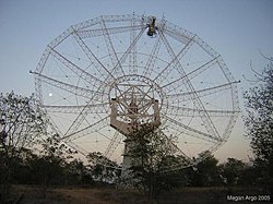
Khodad is a town in the Pune district of Maharashtra state, India. Khodad Village is situated in Junner taluka of Pune district of Maharashtra state, India. It is famous for Giant Metrewave Radio Telescope (GMRT), the largest telescope at metre wavelengths in the world, which attracts radio astronomers from different countries. Khodad is located on Junner & Ambegao taluka border. Khodad is surrounded by Junnar Taluka towards west, Khed Taluka towards South, Parner & Ambegaon Taluka towards East, Shirur Taluka towards North.

References

  1. source?
  2. source?
  3. source?
  4. source?
  5. "तमाशा पंढरीत झाली २ कोटींची उलाढाल -Maharashtra Times". Maharashtra Times. 15 April 2013. Retrieved 18 December 2016.