Kolhapur is a city on the banks of the Panchganga River in the southern part of the Indian state of Maharashtra.

Dhule is a city located in the Dhule District in the northwestern part of Maharashtra state, India known as West Khandesh. Situated on the banks of Panzara River, Dhule is the regional headquarters of MIDC, RTO, and MTDC.
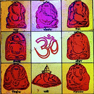
Ashtavinayaka is a Sanskrit term which means "eight Ganeshas". The Ashtavinayaka Yatra refers to a pilgrimage to the eight Hindu temples in the state of Maharashtra, India, centered around the city of Pune. The eight temples house eight distinct idols of Ganesha, the Hindu deity of unity, prosperity, learning, and removing obstacles. Each of these temples has its own individual legend and history, as distinct from each other as the murtis in each temple. The form of each murti of Ganesha and his trunk are distinct from one another. There are other temples of eight Ganesha in various other parts of Maharashtra; however, the ones around Pune are more well known and visited. To complete the Ashtavinayaka Yatra, one must revisit the first temple after visiting all the eight temples.

Roha is a town and taluka in the Raigad district of the Maharashtra state of India. It is located 120 km southeast of Mumbai. It is the starting point of Konkan railways and end point of central railways (Mumbai). Many chemical industries have opened up their manufacturing bases in Roha. Roha is located between the banks of the Kundalika River and the hills of Kalasgiri. It has a population of over 20,849. Roha is connected to Mumbai by Panvel-Roha railway line. Roha is also the northern end of the Konkan Railway. Roha is off of the Mumbai Goa Highway, via the Kolad road.
Baramati ([baːɾamət̪iː]) is a city, a tehsil and a municipal council in Pune district in the state of Maharashtra, India. The city is about 100 km southeast of the city of Pune and about 250 km from Mumbai.

Pune district is a district in Western Maharashtra with Administrative Headquarters in Pune city. Pune district is the most populous district in the Indian state of Maharashtra. It is one of the most industrialised districts in India.

Maharashtra Industrial Development Corporation (MIDC) is a project of the government of Maharashtra state in India and is the leading corporation of Maharashtra. It provides businesses with infrastructure such as land, roads, water supply, drainage facilities and street lights. Dr. Vipin Sharma, IAS, is the CEO of MIDC Maharashtra Industrial Development Corporation.

Shirala also called Battis [32] Shirala is a town and tehsil in Sangli District, India, away 60 kilometres west of the district headquarters, Sangli and about 350 kilometres from Mumbai, capital of Maharashtra state. It is particularly known for its Hindu festival of the snake god.
Gadhinglaj ([ɡəɖᵊɦiŋɡləd͡z]) is a city in India in the Kolhapur district in the southwest corner of the state of Maharashtra, India. It is located on the banks of the river Hiranyakeshi. It is the Taluka (Tehsil) headquarters of Gadhinglaj Taluka and a subdivision headquarters of the Gadhinglaj Subdivision of the Kolhapur District. It is governed by a municipal council. The rapidly growing city is the third largest in the Kolhapur District, with population of more than 50,000. Places to visit like Samagad fort, temples and beautiful weather.
Shirur is an administrative subdivision of the Pune district in the Indian state of Maharashtra. It is located on the eastern boundary of the district, on the banks of the Ghod River. The town is also called Ghodnadi to distinguish it from other locations that have the same name. Ghodnadi in Marathi Language means Ghod River.
Chakan is a census town in India, in Pune district of the Indian state of Maharashtra. While agriculture remains an important factor, the town's industrial development is quickly urbanizing the area. The Independent referred Chakan as India's "Motor City".
Patalganga is a huge industrial area of the Maharashtra Industrial Development Corporation (MIDC) near Karjat and Panvel. It has got its name from the Patalganga River. Nearest town and junction is Karjat. Nearest hospital is Dhirubhai Ambani Hospital.

The economy of the state of Maharashtra is the largest in India. Mumbai, the capital of Maharashtra and often described as the New York of India or Manhattan of India, is the financial capital and the most populous city of India with an estimated city proper population of 12.5 million (1.25 crore). The city is the entertainment, fashion, and commercial centre of India. Mumbai hosts the largest urban economy of any city in India. is considered the financial capital of India with the headquarters of almost all major banks, financial institutions, insurance companies and mutual funds being based in the city. India's largest stock exchange Bombay Stock Exchange, the oldest in Asia, is also located in the city. More than 41% of the S&P CNX 500 conglomerates have corporate offices in Maharashtra.

Latur is a city in the Indian state of Maharashtra, and is one of the largest cities of the Marathwada region. It is the administrative headquarters of Latur district and Latur Taluka. The city is a tourist hub surrounded by many historical monuments, including Udgir Fort and Kharosa Caves. The people in Latur are called Laturkar. The most spoken language in Latur is Marathi. The city's quality of education attracts students from all over Maharashtra. It is a drought prone area with acute water shortage in its city and rural areas. The economy is agriculture intensive, but in recent years is also dependent on Educational sector & its allied activities. Industrial development is minimal in the district. Latur is 43 kilometers from the epicenter of the devastating 1993 Latur earthquake.
Saswad is a municipal council located on South-Eastern corridor of Pune district of the Indian state of Maharashtra. Saswad is situated on the banks of the Karha River. Saswad is about 31 km from Pune-Central Station.

Parner taluka is a taluka in Ahmednagar district in the state of Maharashtra in western India.

Shirur taluka, is a taluka in Haveli subdivision of Pune district of state of Maharashtra in India. The town is situated on the bank of river Ghod and hence it was also known as Ghodnadi in 20th Century. The town is on the border of Pune & Ahmed Nagar District and hence, main trading center for Shirur Taluka as well as Parner Taluka located in Ahmed Nagar District.
After 1960, Maharashtra Industrial Development Corporation (MIDC) began acquiring land and setting up industrial estates. Land was acquired near Shendra village on Aurangabad - Jalna highway in the 1990s.
Shikrapur is a panchayat village in the state of Maharashtra, India. It is the largest village in the Shirur Taluka of Pune District in Maharashtra.