Chitrakoot, Madhya Pradesh

Last updated

Chitrakoot
Mandakini river in chitrkoot.jpg
Temples in Hanuman Dhara.JPG
Ramghat at chitrakoot.jpg
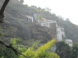
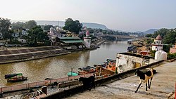
Mandakini river, View of ghats at Chitrakoot,Temples in Hanuman Dhara
Madhya Pradesh location map.svg
Red pog.svg
Chitrakoot
Coordinates: 25°00′N80°50′E / 25.00°N 80.83°E / 25.00; 80.83
CountryFlag of India.svg  India
State Madhya Pradesh
District Satna
Population
 (2011)
  Total23,316
Languages
  Official Hindi
Time zone UTC+5:30 (IST)
ISO 3166 code IN-MP
Vehicle registration MP-19

Chitrakoot is a pilgrimage centre and a nagar panchayat in the Satna district in the state of Madhya Pradesh, India. Connected to the Indian epic Ramayana, it is a place of religious, cultural, historical and archaeological importance, situated in the Bundelkhand region. It borders the Chitrakoot district in Uttar Pradesh, whose headquarters Chitrakoot Dham is located nearby. The city lies in the historical Chitrakoot region, which is divided between the present-day Indian states of Uttar Pradesh and Madhya Pradesh. It is known for a number of temples and sites mentioned in Hindu scriptures.

Contents

It attracts pilgrims throughout the year on occasions such as Amavasya, Somwati Amavasya, Deepavali, Sharad-Poornima, Makar Sankranti, Rama Navami and for Free Eye Care Medical Camps. Noted 'Ayurvedic' and 'Yoga' centres like 'Arogyadham' are located in Chitrakoot.

Legend

Chitrakuta, identified with modern Chitrakoot, is one of the important places connected to the epic Ramayana , [1] where Rama is persuaded by his brother Bharata to return to Ayodhya and where Rama performed the last rites of his father Dasharatha in presence of all the gods and goddesses. The forests of Chitrakuta is where Rama, Sita, and Lakshmana took refuge and spent 14 years in the woods, which was already home to several hermits. [2] The ancient Indian sages, including Atri, Agastya, and Sharabhanga, were said to have meditated in the forests of Chitrakuta. [3]

Geography

Chitrakoot means the 'Hill of many wonders'. Chitrakoot region falls in the northern Vindhya Range spread over the states of Uttar Pradesh and Madhya Pradesh. The region is included in the Chitrakoot district of Uttar Pradesh and the Satna district of Madhya Pradesh. Chitrakoot district in Uttar Pradesh was created on 4 September 1998. [4]

Demographics

As of the 2011 Census of India, Chitrakoot had a population of 23,316. Males constitute 54.36% of the population and females 45.63%, making the Female Sex Ratio of 840 against the state average of 931. Chitrakoot has an average literacy rate of 70.01%, lower than the national average of 74% and higher than the state average of 69.32%; with male literacy of 79.49% and female literacy of 58.40%. 15.72% of the population is under 6 years of age. [5]

Related Research Articles

<span class="mw-page-title-main">Bagelkhand</span> Region in Madhya Pradesh and Uttar Pradesh, India

Bagelkhand or Baghelkhand is a proposed state and a mountain range in central India that covers the northeastern regions of Madhya Pradesh and a small area of southeastern Uttar Pradesh.

<span class="mw-page-title-main">Rewa, Madhya Pradesh</span> City in Madhya Pradesh, India

Rewa is a city in the north-eastern part of Madhya Pradesh state in India. It is the administrative center of Rewa District and Rewa Division. The city lies about 420 kilometres (261 mi) northeast of the state capital Bhopal and 230 kilometres (143 mi) north of the city of Jabalpur. The maximum length of Rewa district is 125 km from east to west and the length of Rewa from north to south is 96 km. This area is surrounded by Kaimur hills to the south Vindhyachal ranges pass through the middle of the district. It is famous for the founding of the world's first white tiger safari and beetle nut toys.

<span class="mw-page-title-main">Bithoor</span> Town in Uttar Pradesh, India

Bithoor or Bithur is a town in Kanpur district, 23.4 kilometres (14.5 mi) by road north of the centre of Kanpur city, in Uttar Pradesh, India. Bithoor is situated on the right bank of the River Ganges, and is a centre of Hindu pilgrimage. Bithoor is also the centre for War of Independence of 1857 as Nana Sahib, a popular freedom fighter who was based there. The city is enlisted as a municipality of Kanpur metropolitan area.

<span class="mw-page-title-main">Rewa district</span> City and district of Madhya Pradesh in India

Rewa district is a district of the Madhya Pradesh state in central India. The city of Rewa is the district headquarter. Rewa is sometimes called – 'Land of White Tigers' as the first White Tiger was discovered here in 1951 by Maharaja of the province, Martand Singh in the nearby jungle of Govindgarh. Rewa was the capital city of once a state – Vindhya Pradesh.

Satna is a city in the Indian state of Madhya Pradesh. It serves as the headquarters of Satna district. It is 7th largest city and 8th most populous city of the state. The city is 500 km east of the state capital Bhopal. The city is distributed over a land area of 111.9 square kilometres.

<span class="mw-page-title-main">Maihar</span> City in Madhya Pradesh, India

Maihar is a city in the state of, Madhya Pradesh, India. It also serves as the headquarter of the Maihar District. Maihar is known for the temple of the revered mother goddess Sharda situated on Trikuta hill.

Nagod or Nagaud is a town and a nagar panchayat in Satna district in the Indian state of Madhya Pradesh. It is located 17 miles (27 km) from the town of Satna. It is the administrative headquarters of Nagod Tehsil.It is believed that it was a small state owned by an oil-pressing people, known as 'Teli', who were exiled by the Pratiharas. Pratiharas originally came from Kannauj and belong to Agnikula Rajput.

<span class="mw-page-title-main">Chitrakoot Dham</span> City in Uttar Pradesh, India

Chitrakoot Dham is a city in the Chitrakoot district, within the state of Uttar Pradesh, India. It is the headquarters of the Chitrakoot district. Situated in the Bundelkhand region, it holds great cultural, historical, religious and archaeological importance and it is said that Lord Rama spent 11 years of exile in Chitrakoot. It is connected to the town of Chitrakoot, situated in the Satna district of Madhya Pradesh.

Gola Gokaran Nath or Gola is the city, municipal board, thana and tehsil in Lakhimpur Kheri district in the Indian state of Uttar Pradesh.

Jaitwara is a town and a nagar panchayat in Satna district in the Indian state of Madhya Pradesh.

Maudaha is a city and a Municipal Board in Hamirpur district, Uttar Pradesh, India.

Nowrozabad or Khodargama is a city and a Nagar Palika in Umaria district in the Indian state of Madhya Pradesh. Kendriya Vidyalaya Nowrozabad is situated in the G.M Complex Johilla area. Nowrozabad is the head office of Johilla area. The nearest Airport is at Jabalpur in Madhya pradesh. Nowrozabad Railway Station is on the Katni - Anuppur rail route. There are many coal mines around here. National Highway 43 has its route through Nowrozabad.

Shankargarh is a town and a nagar panchayat in Prayagraj district in the Indian state of Uttar Pradesh.

<span class="mw-page-title-main">Unchehara</span> Town in Madhya Pradesh, India

Unchehara is a town and a nagar panchayat in Satna district in the Indian state of Madhya Pradesh. It is a block and one of six tehsils of Satna district. The town lies in the vicinity of Vindhya Range in Central India.

<span class="mw-page-title-main">Chitrakoot district</span> District of Uttar Pradesh in India

Chitrakoot district is one of the districts of Uttar Pradesh state of India in the Bundelkhand region and Chitrakoot city is the district headquarters. Chitrakoot district is a part of Chitrakoot Division. The district occupies an area of 3,216 km².The district has a population of 991,730. As of 2011 it is the second least populated district of Uttar Pradesh, after Mahoba.

<span class="mw-page-title-main">Govindgarh, Madhya Pradesh</span> City in Madhya Pradesh, India

Govindgarh, the summer capital of Mahraja Rewa, is about 18 km from Rewa in Madhya Pradesh, India. The is Rewa, with an area of about 13,000 mi², was the largest princely state in the Bagelkhand Agency and the second largest in Central India Agency. The British political agent for Bagelkhand resided at Satna, on the East Indian railway. The Bagelkhand capital establish in Rewa under the Rewa Maharaja.Bagheli is the local language of the region.It's neighbouring towns are Manikawar, Gurh and Rewa.

Sumerpur, also known as Bharuwa Sumerpur, is a town and a nagar panchayat in Hamirpur district, Uttar Pradesh, India.

Kothi is a town and a nagar panchayat in Satna district in the Indian state of Madhya Pradesh.

Chitrakoot may refer to:

Ram Van Gaman Path is the path that Lord Rama, Sita and Lakshmana took during their 'vanvaas' or exile years. It starts from Ayodhya and ends at Sri Lanka. This path is much revered in the Hindu religion as various key incidents of Lord Rama’s life have taken place on this path.

References

  1. Kishore, B. R. (2007). Ramayana. Diamond Pocket Books (P) Ltd. p. 42. ISBN   978-81-7182-070-2.
  2. "Chitrakoot: Mythology Revisited". OutlookIndia.com. Outlook Traveller. 15 May 2017. Retrieved 30 December 2021.
  3. Valmiki; Venkataswami, M. N. The Ramayana (Complete). Library of Alexandria. p. 421. ISBN   978-1-4655-7792-4.
  4. District Unit Chitrakoot, National Informatics Centre
  5. https://censusindia.gov.in/2011census/dchb/2312_PART_B_DCHB_SATNA.pdf [ bare URL PDF ]