This article needs additional citations for verification .(May 2013) |
Daund | |
---|---|
City | |
Coordinates: 18°27′47″N74°34′44″E / 18.46306°N 74.57889°E | |
Country | ![]() |
State | Maharashtra |
District | Pune |
Named for | Dhaumya Rishi |
Government | |
• Body | Municipality |
Elevation | 514 m (1,686 ft) |
Population (2018) | |
• Total | 590,021 |
Languages | |
• Official | Marathi |
Time zone | UTC+5:30 (IST) |
PIN | 413801 and 413802 |
Telephone code | 02117 |
Vehicle registration | MH 12,42 |
Website | www |
Daund is a city, municipal council, and headquarters of the Daund tehsil in the Pune district in the state of Maharashtra, India. The city of Daund is located on the Bhima River.
In ancient times, a sage named Dhaumya Rishi stayed here; hence, people started calling it after him: "Dhaum". Gradually "Dhaum" became "Dhoand", then "Dhaundh". According to the epic Mahabharata , Krishna's wife Rukmini went in the "Dhindir forest"; this ancient "Dhindir Van" is today's Daund.[ citation needed ]
Shahaji, father of Chhatrapati Shivaji Maharaj, was a sardar in the Nizam Shahi. He was granted Daund as a jagir, which included Bahadurgad, a fort in Pedgaon on the banks of the Bhima River (which still exists today). [1]
In 1739, the Bajirao–Mastani affair had brought clashes among the Peshwa family, hence Bajirao Peshwa took Mastani away from Pune and made her stay in Patas. Henceforth, Bajirao and Mastani met at the Firangai Devi temple in Kurkumbh.
The horse business in Daund flourished during this time.[ citation needed ] The water of the rivers Bhima, Nira, Pravara, Ghod, and Godavari were believed to be best suited for horses, and that the horses raised drinking these waters would be strong, quick, and loyal. The area of Bhimthadi, which is close to Daund, was known for its good horse breeds, and people preferred buying ponies from there exclusively.[ citation needed ]
Due to heavy loans at the end of the Peshwa Era, Daund and some villages from Pune fell under control of 'Girgosavi'.[ clarification needed ]
In the 1850s, with the construction of railways during British rule, the Bombay–Chennai broad-gauge track passed via Daund, and the Daund–Baramati metre-gauge track was constructed. Daund became a junction after the broad-gauge Daund–Manmad connection was established. In 1928, Daund was connected to Srigonda when the bridge over Bhima River was constructed. A receiver station of the Imperial Wireless Chain was installed three kilometers outside the town.
From 1942 to 1945, two military camps were set up in Daund.
Daund is located at 18°28′N74°36′E / 18.47°N 74.6°E , about 514 m (1,686 ft) above sea level on the western margin of the Deccan Plateau. The town and surrounding area have mostly flat terrain, with hills rising 600 m (2,000 ft) to the south near Kurkumbh. Daund is located on the southern bank of Bhima River, a major river in Maharashtra. The Ujani reservoir on the river is around 25 km (16 mi) southeast of the town.
Daund lies very close to the seismically active zone around Koyna Dam, about 130 km (81 mi) southeast of the town, and has been rated as Zone 3 (on a scale of 2 to 5, with 5 being the most prone to earthquakes) by the India Meteorological Department.
The climate of Daund is generally hot and dry, and the area receives scant rainfall.
Primary crops include wheat, sugar cane, oranges, and sweet limes. Daund has a large working class population, and the primary occupation is farming. Maharashtra Industrial Development Corporation is a major employer. Daund is currently being developed as a hub for pharmaceutical industries, and currently has facilities of companies such as Cipla, Emcure Pharmaceuticals, and Dia Ichi. [2]
National Highway 160 passes through Daund, and National Highway 65 is just 9 km (5.6 mi) north of town. It is also on the Sinner–Shirdi–A.Nagar–Daund–Phaltan–Vita–Miraj–Chikodi route.
Daund–Ausa SH 67 also passes through Daund city. MSRTC buses are available to Pune, Mumbai, Aurangabad, Ahmednagar, Sangli, Miraj, Shirdi, Tuljapur, Satara, Beed, Jamkhed, and Karjat.
Daund is served by rail by the Daund Junction and the Daund Chord Line, which are managed by the Pune railway division of the Central Railway. Daund Junction lies on the Mumbai–Chennai line, Daund–Manmad line, and the Daund–Baramati branch line. Daund Chord Line lies on a short line which connects Mumbai–Chennai line and Daund–Manmad line. [3]
Daund is a major freight redistribution hub.
As of 2011 [update] India Census, [4] Daund had a population of 49,450 of which 25,117 were males and 24,333 were females. There were 5,721 children below 6 years old. Daund had an average literacy rate of 77.34%, higher than the national average of 74.04%. Male literacy was 80.44% and female literacy was 74.13%.
The town has a significant population working as employees of Indian Railways and the State Reserve Police Force (SRPF).
Since more than 82% of the city's population are Hindus, there are a significant number of temples in the town. Important Hindu temples in Daund include Shree Vitthal Rukmini Temple (प्रति पंढरपूर), Shree Balaji temple, Shree Gajanan Maharaj Temple, and Shree Swami Samarth Temple. The Gram Daivat of Daund is Shree Bhairavnath Maharaj Temple. Shree Firangai Mata temple, located 10 km from Daund at Kurkumbh, is the first of the 51 Shakti Pithas. Devotees from all over Maharashtra, Madhya Pradesh, and Karnataka visit the temple. Rama Navami is a large religious event, in which a sculpture of Lord Rama is carried throughout the town on a palanquin.
The town has a Jain Digambara temple known as the "1008 Chandraprabhu Bhagwan Mandir", which is known for its architecture and lack of iron in construction. The temple is built of marble and has a marble manastambha. It is located on Ahmednagar Road.
Central Railway is one of the 19 zones of Indian Railways. Its headquarters are located at Mumbai. It has the distinction of operating the first passenger railway line in India, which opened from Mumbai to Thane on 16 April 1853.
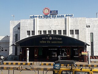
Manmad ( [mənmaːɖ]) is a town in Nashik district in Maharashtra, India. It is the third largest city in Nashik district, with a population of approximately 80,000. Geographically, the town lies within Nandgaon Tehsil in Nashik District. Though it has a larger area and population than most Tehsils in the district, it does not have a Tehsil office.
Pune district is a district in Western Maharashtra with Administrative Headquarters in Pune city. Pune district is the most populous district in the Indian state of Maharashtra. It is one of the most industrialised districts in India.
Indapur is a town and a municipal council in Pune district in the Indian state of Maharashtra. Indapur is known for Jahagir of Chhatrapati Shivaji Maharaj's father and grandfather. Chhatrapati Shivaji Maharaj's grandfather Malojiraje died in battle in Indapur.
Sangole or (Sangola) is a city with a municipal council in Solapur district in the Indian state of Maharashtra. It is situated near Holy city Pandharpur. It is located at the intersection of state highways SH-161, SH-3, and SH-71.
Shirur is an administrative subdivision of the Pune district in the Indian state of Maharashtra. It is located on the eastern boundary of the district, on the banks of the Ghod River. The town is also called Ghodnadi to distinguish it from other locations that have the same name. Ghodnadi in Marathi Language means Ghod River.
Shrivardhan is a subdistrict/upazila/tehsil, city, and local governing body in the Raigad district of the Indian state of Maharashtra. It is renowned as the birthplace of Balaji Vishwanath, the first Peshwa (1713–1720) and father of Bajirao I, who held the position of Deshmukh in the town. It has developed into a seaside resort, along with the nearby town of Harihareshwar, which also has a Shiva temple. Located on a peninsula, the town itself boasts many beaches, in addition to proximity to numerous other beach destinations such as Diveagar Beach and Kondivali Beach. People from across Maharashtra come to Shrivardhan and the nearby beaches all year round.
Tasgaon is a city in Maharashtra and Taluka in Sangli district in the Indian state of Maharashtra. Tasgaon city is developing city in Maharashtra. Tasgaon was given as Jahagir to Parshuram Bhau Tasgaonkar by Narayanrao Ballal Peshwa in 1774. Tasgaon Sansthan was lapsed by British during ruling of Shrimant Ganpatrao Tasgaonkar.
Saswad is a municipal council located on South-Eastern corridor of Pune district of the Indian state of Maharashtra. Saswad is situated on the banks of the Karha River. Saswad is about 31 km from Pune-Central Station.
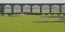
Daund taluka is a taluka or subdivision of Pune district of the state of Maharashtra in India. The town of Daund is the only major urban area in this predominantly rural area. Daund railway station is a major railway junction. All southern railways are connected to this route, and also divided the Nagar railway to north Indian railway, like Delhi, Solapur division, Daund junction and then joined to the Pune district junction. To reach the Siddhi Vinayak Siddhatek Ganpati temple, one has to travel 14 km to Daund by road.
Pune railway division is one of the five railway divisions under the jurisdiction of Central Railway zone of the Indian Railways. It has its headquarters located at Pune in the Indian state of Maharashtra state. The other railway divisions are Mumbai CSMT, Nagpur, Solapur and Bhusawal. There are 71 railway stations in Pune railway division.
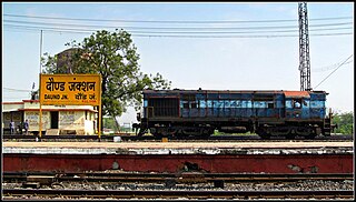
Daund Junction railway station is a railway junction station on the Mumbai–Chennai route of Indian Railways located in Pune district, Maharashtra, India. The Daund–Manmad line and the Daund–Baramati branch line start from here. Daund is a major freight redistribution hub.
The 11077 / 11078 Jhelum Express is a daily train on the Indian Railways. It runs from Pune, the cultural capital of Maharashtra, to Jammu Tawi, the winter capital of Jammu and Kashmir, in North India.
The Bhusawal–Kalyan section is part of the Howrah–Nagpur–Mumbai line and Howrah–Prayagraj–Mumbai line. It connects Bhusawal and Kalyan both in the Indian state of Maharashtra. One of the branch lines, Jalgaon–Surat line, runs partly in Gujarat.
Dadar–Solapur section is part of the Mumbai–Chennai line. It connects Dadar and Solapur both in the Indian state of Maharashtra.
Solapur railway station is located in Solapur district in the Indian state of Maharashtra and serves Solapur city and the industrial belt around it. It is headquarters of Solapur Railway Division and a part of Central Railway zone.
Yevat railway station is a suburban railway station in Pune district, Maharashtra. Its code is YT. It serves Yevat, a suburban area of the city. The station consists of two platforms. The platforms are connect by a sturdy foot-over-bridge. It has basic facilities, however it is scenic. It serves as the closest railway station to visit the beautiful Hindu temple of [[Bhuleshwar|Bhuleshwar]] dedicated to Lord Shiva.
Parli Vaijnath railway station is a railway station in Beed district in the Indian state of Maharashtra. It serves Parli Vaijnath city.
National Highway 160, commonly referred to as NH 160 is a national highway in India. It is a spur road of National Highway 60. NH-160 traverses the states of Maharashtra and Karnataka in India.
Daund Cord Line railway station is a railway station on bypass line joining Mumbai–Chennai line and Daund–Manmad branch line, located in Pune district, Maharashtra, India. It is also a junction station, although it is not named so.