
Meghalaya is a state in northeast India. Meghalaya was formed on 21 January 1972 by carving out two districts from the state of Assam: (a) the United Khasi Hills and Jaintia Hills and (b) the Garo Hills. The estimated population of Meghalaya in 2014 was 3,211,474. Meghalaya covers an area of approximately 22,429 square kilometres, with a length-to-breadth ratio of about 3:1.

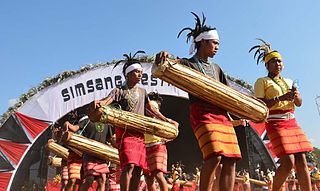
The Khasi people are an ethnic group of Meghalaya in north-eastern India with a significant population in the bordering state of Assam, and in certain parts of Bangladesh. Khasi people form the majority of the population of the eastern part of Meghalaya, that is Khasi Hills, constituting 78.3% of the region's population, and is the state's largest community, with around 48% of the population of Meghalaya. They are among the few Austroasiatic-speaking peoples in South Asia. The Khasi tribe holds the distinction of being one of the few remaining tribes that have a matrilineal society. Under the Constitution of India, the Khasis have been granted the status of Scheduled Tribe.

West Garo Hills is an administrative district in Garo Hills of the state of Meghalaya in India. Tura town is the administrative headquarters of the district. The district occupies an area of 3714 km². In 2011, its population was 643,291. As of 2011, it is the second most populous district of Meghalaya, after East Khasi Hills.
Williamnagar, formerly known as Simsanggre, is the headquarters of East Garo Hills district in the state of Meghalaya in India.

The Garo Hills are part of the Garo-Khasi range in Meghalaya state of India. They are inhabited by the Garo people. It is one of the wettest places in the world. The range is part of the Meghalaya subtropical forests ecoregion.
Benarat Cavern is a cave system situated in Mount Benarat at the northern end of Mulu National Park in Malaysia. As of 2011, it is the third-longest known cave in Asia at 50 km.
Krem Liat Prah is the longest natural cave in South Asia. Also known as the Cave of the Tiger, it is one of the longest limestone caves in the world.

Cave research, encompassing the study of speleology and biospeleology, is still in its infancy in India. Although there are thousands of caves in India, research expeditions occur in few states. The Siju Cave in Meghalaya is the first limelighted natural cave from India. Several studies were carried out in this cave in the early 20th century. The Kotumsar Cave in Central India is one of the most explored caves of India, and biologists have classified many types of cavernicoles, i.e. trogloxenes, troglophiles and troglobites, from this cave.

The Belum Caves, located in Nandyala district of Andhra Pradesh's Rayalaseema region, is the second largest cave system on the Indian subcontinent, known for its speleothems, such as stalactite and stalagmite formations. The Belum Caves have long passages, galleries, spacious caverns with fresh water and siphons. This cave system was formed over the course of tens of thousands of years by the constant flow of underground water from the now-disappeared river Chitravathi. The cave system reaches its deepest point at the point known as Pataalaganga. Belum Caves have a length of 3,229 m (10,593.8 ft), making them the second largest caves on the Indian Subcontinent after the Krem Liat Prah caves in Meghalaya. It is one of the centrally protected Monuments of National Importance.

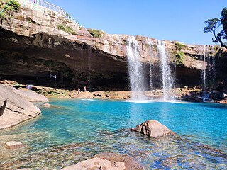
Nohsngithiang Falls is a seven-segmented waterfall located 1 kilometre (0.62 mi) south of Mawsmai village in East Khasi Hills district in the Indian state of Meghalaya. The water falls from a height of 315 metres (1,033 ft) and has an average width of 70 metres (230 ft). making it one of the tallest waterfalls in India.
Williamson Ampang Sangma, was a Garo leader, and the first Chief Minister of Meghalaya. He was also the first Governor of Mizoram among the Garos in 1989.
West Jaintia Hills is an administrative District in the state of Meghalaya in India. The united district was created on 22 February 1972 and occupied an area of 3819 km2. It had a population of 272,185. The district is part of the Meghalaya subtropical forests eco-region. With the bifurcation of the erstwhile Jaintia Hills District into East and West Jaintia Hills Districts, West Jaintia Hills District came into existence on 31 July 2012 with its headquarters at Jowai. Jowai is the host of all the heads of important governmental offices and establishments, educational institutions, hospitals, banking institutions, etc.

Siju Dobakkol, also known as Siju Cave or Bat Cave in English, is one of the most well-known and significant caves in India. Located in the Garo Hills of the North East Indian state of Meghalaya, near Napak Lake and the Simsang River game reserve, it is a renowned limestone cave famous for its impressive stalagmite and stalactite formations. Siju Dobakkol is home to tens of thousands of bats, and holds great significance in the field of biospeleology, being one of the most thoroughly researched caves in the Indian subcontinent.

Torca del Carlista is a large limestone cavern found in Cantabria, Spain, approximately 35 kilometres (22 mi) from the city of Bilbao. The entrance, up the slopes of the Cantabrian Mountains, is only a single metre wide. The entry passage descends some 45 metres (148 ft) vertically in a narrow chimney before opening up into the cavern's main gallery. Some 520 metres (1,710 ft) long and 245 metres (804 ft) wide, the total surface area of the cavern exceeds 20 acres, or 76,620 square metres (824,700 sq ft). The main chamber is the fifth-largest underground chamber in the world, with a ceiling that reaches 120 metres (390 ft) at its highest point.
Krem Synrang Pamiang is a cave located in the Jaintia Hills district of Meghalaya state, India. It is the third longest cave of India, with 14,157 m of surveyed passage.
The Meghalayan age is the name given in 2018, by the International Commission on Stratigraphy, to the current age or latest geologic age – or uppermost stage of the Quaternary. It is also the upper, or latest, of three subdivisions of the Holocene epoch or series. This way of breaking down time is based only on geology; for example, it is unrelated to the three-age system of historical periods into which human development is sometimes divided.
Bullita Cave, also known as Burkes Backyard Cave, is a cave located in Gregory National Park of the Northern Territory, Australia. It is one of the longest surveyed caves in both Australia and the world.
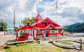
Hinduism is a minority religion in the Meghalaya state of India constituting 12% of the state's population. The Nartiang Durga Temple in Meghalaya is one of the 51 Shakti peethas on Earth and is considered by Hindus of Meghalaya as the permanent abode of Goddess Durga. Hinduism is a popular religion practice by Rabhas, Hajongs, Kochs, Rajbongshis, Mikirs, Bengalis, Nepalis, Biharis etc.
Mawmluh Cave is a maze cave in the state of Meghalaya in northeast India. At 7.2 km in length, it is the fourth longest cave in the Indian subcontinent. The cave, which has several entrances, has formed at the junction between an early Eocene dolomite and a sandstone formation. It contains numerous stalactites, stalagmites, columns and drapes, collectively termed speleothems.
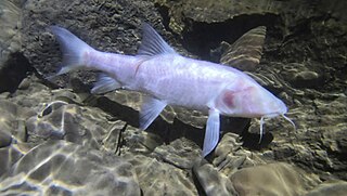
Neolissochilus pnar is a species of subterranean cyprinid in the genus Neolissochilus. It is the largest known subterranean fish, a title formerly held by the blind cave eel.

