
Doda district is an administrative district of the Jammu division of Indian-administered Jammu and Kashmir in the disputed Kashmir region.

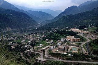
Bhaderwah or Bhadarwah is a town, tehsil, sub-division and also additional district in the Doda district of the Jammu Division of Jammu and Kashmir, India. It is also known as Chota Kashmir for its scenery and for its high literacy rate it is known as Kerala of Jammu and Kashmir.
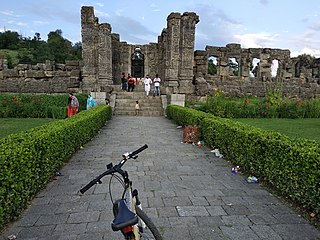
Mattan is a town, tehsil and a notified area committee, near Anantnag city in the Anantnag district of the Indian union territory of Jammu and Kashmir.
Ramban district is an administrative district in the Jammu division of Indian-administered Jammu and Kashmir in the disputed Kashmir region. It is located in a valley surrounded the Pir Panjal range. It was carved out as a separate district from erstwhile Doda district in 2007. It is located in the Jammu division. The district headquarters are at Ramban town, which is located midway between Jammu and Srinagar along the Chenab river in the Chenab valley on National Highway-44, approximately 151 km from Jammu and Srinagar.

Kishtwar district is an administrative district of the Jammu division of Indian-administered Jammu and Kashmir in the disputed Kashmir region. As of 2011, it is the largest and the least populous district of Jammu and Kashmir.

The Chenab Valley is a river valley formed by the Chenab River. The term is also used collectively for Doda, Kishtwar and Ramban districts of Jammu Division in Jammu and Kashmir, India. These districts were formerly part of a single district, called Doda.
Chack Diyalla or Chakdyala is a village in the Indian union territory of Jammu and Kashmir. It is located in Hiranagar tehsil of Kathua district.
Badran is a village located in district Budgam in the Indian administered union territory of Jammu and Kashmir.
Shankerpora, also known as Shankerpur, is a village in Anantnag district in the Indian-administered union territory of Jammu and Kashmir.

Rajpora, also known as Rajpour, is a Village and a Tehsil in the Pulwama district of the Kashmir Valley of Jammu and Kashmir, India. It is located 43 km (27 mi) away from Srinagar and 299 km (186 mi) away from Jammu. Rajpora is situated at 1,800 metres (5,900 ft) above the mean sea level.
Diver Anderbugh is a village situated in the Lolab Valley, Kupwara, Jammu and Kashmir, India. The village is combination of two places, Diver and Anderbugh. The site is connected to the village of Anderbugh. It is situated 25 kilometres (16 mi) away from district headquarter Kupwara.

Ichgam, also known as Ichigam, is a census town located in the Indian administered union territory of Jammu and Kashmir's Budgam district. It falls under the administrative division of tehsil Budgam, one of the nine tehsils of district Budgam. It is one of the most populated area of Budgam district. It is roughly 5 km (3.1 mi) away from district Budgam and nearly 19 km (12 mi) away from Srinagar, the summer capital of union territory of Jammu and Kashmir. Ichgam village consists of four blocks — Ichgam-A, Ichgam-B, Ichgam-C and Ichgam-D. The village consists of both major sects of Islam, Shias (85-90%) and Sunnis(10-15%). There is also a Hindu minority.
Marmat is a tehsil in the Doda district of Jammu and Kashmir, India. Marmat consists of 18 villages, including the village of Marmat. It is 45 kilometres south of the district headquarters of Doda.
Dooniwari or Dooniwara is a village in Budgam district of the Indian union territory of Jammu and Kashmir, situated 13 km (8.1 mi) away from Srinagar city and 18 km (11 mi) away from Budgam town. The total geographical area of village is 168 ha. Dooniwari has a total population of 1,839 citizens. There are about 278 houses in Dooniwari village as per 2011 census. Areas in its locality include Wathoora, Gopalpora, Chattergam, Kralapora and Bagati Kani Pora.
Zoonipora is a medium size village in the locality of Dooniwari, located in BAGAT KANIPORA Tehsil of Budgam district, Jammu and Kashmir with total 57 families residing. The Zooni Pora village has population of 471 of which 237 are males while 234 are females as per Population Census 2011.
Sen Brahmana is a village located in Udhampur Tehsil of Udhampur district near Chenab river(Tawi) in Jammu and Kashmir, India. It is situated 22 km away from the town of Udhampur, which is also district & sub-district headquarter of Sen Brahmana village. The village is named after Sen Brahmin Clan. According to Census 2011 information, the location code or village code of Sen Brahmana village is 004891. Sen Brahmana is a medium size village with total 249 families residing. The Sen Brahmana village has population of 1391 of which 699 are males while 692 are females as per Population Census 2011.
Halaran is a village and panchayat located in the Kahara tehsil of Doda district in the Indian administered union territory of Jammu and Kashmir. The village is situated approximately 13 kilometers away from the sub-divisional headquarters, Thathri, and 43 kilometers away from the district headquarters, Doda.
Dhara is a village located in the Doda Tehsil of the Doda district in the Indian administered Union Territory of Jammu and Kashmir.
Thatharka is a village and panchayat located in the Gool tehsil of Ramban district in the Indian-administered Union Territory of Jammu and Kashmir. It is situated approximately 24 kilometers away from the district headquarters Ramban.
Gatha is a village located in the Bhaderwah Tehsil in the Doda district of the Indian-administered union territory of Jammu and Kashmir.

