Kargil War Memorial

Last updated

Kargil War Memorial. On the background is the name of soldiers who died during the battle, and a memorial for them in the front. Kargilwarmemorialdarss3.jpg
Kargil War Memorial. On the background is the name of soldiers who died during the battle, and a memorial for them in the front.

The Kargil War Memorial, also known as Dras War Memorial, is a war memorial built by the Indian Army in the town of Dras, near Kargil city in Kargil district of Ladakh, India, commemorating the 1999 Kargil War between India and Pakistan. [1] The memorial is located on the Srinagar-Leh National Highway 1D, [2] about 5 km from the city centre across the Tiger Hill, Kargil.

Contents

History

In the winter of 1998–99, the Pakistani Army crossed the Line of Control (LoC) and occupied numerous heights in Indian State of Jammu and Kashmir. Pakistani forces were dominating the National Highway and roads connecting Leh (Ladakh) and Kargil to Srinagar. The Indian Army launched Operation Vijay ("Victory") in May 1999 to retake the territory, leading to fierce battles in the harsh mountain environment. The operation continued for over two months, leading to a stalemate, and eventual withdrawal of Pakistani troops on the intervention nd instructions of USA, to avoid full-scale war between two nuclear states and for ensuring regional peace.

Each year, 26 July is observed by India as Kargil Vijay Diwas (Kargil Victory Day), during which the Prime Minister of India pays tribute to the soldiers at Amar Jawan Jyothi at the India Gate, New Delhi. [2]

A makeshift memorial is said to have been constructed by troops of 108 Engineer Regiment at the site to honor Indian troops in 2000. The memorial in its present form was constructed by the Indian Army in November 2014.

Design

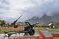
The central feature of the memorial is a pink sandstone wall bearing a brass plate engraved with names of the soldiers who died during Operation Vijay. Visible from the site are the Tololing Heights, Tiger Hill, and Point 4875 (Batra Top), where fighting took place during the conflict. [3]

The memorial features the Captain Manoj Pandey gallery, which commemorates a young officer who was posthumously awarded the Param Vir Chakra, India's highest military award, for leadership during the war.

Over the years, several infrastructural improvements have been made to the site. On 26 July 2012, the Flag Foundation of India presented to the memorial a giant national flag measuring 11.4 by 7.6 metres (37+12 by 25 ft) and weighing 15 kg, on a 30-metre (100 ft) flag pole. The Dras War Memorial is now an important landmark and a major tourist attraction in Western Ladakh—in the year 2016, it received about 1,25,000 visitors.

Related Research Articles

<span class="mw-page-title-main">Ladakh</span> Region administered by India

Ladakh is a region administered by India as a union territory and constitutes an eastern portion of the larger Kashmir region that has been the subject of a dispute between India and Pakistan since 1947 and India and China since 1959. Ladakh is bordered by the Tibet Autonomous Region to the east, the Indian state of Himachal Pradesh to the south, both the Indian-administered union territory of Jammu and Kashmir and the Pakistan-administered Gilgit-Baltistan to the west, and the southwest corner of Xinjiang across the Karakoram Pass in the far north. It extends from the Siachen Glacier in the Karakoram range to the north to the main Great Himalayas to the south. The eastern end, consisting of the uninhabited Aksai Chin plains, is claimed by the Indian Government as part of Ladakh, and has been under Chinese control since 1962.

<span class="mw-page-title-main">Leh</span> City in Indian-administered Ladakh, Kashmir region

Leh is a city in Indian-administered Ladakh in the disputed Kashmir region. It is the largest city and the joint capital of Ladakh. Leh, located in the Leh district, was also the historical capital of the Kingdom of Ladakh. The seat of the kingdom, Leh Palace, the former residence of the royal family of Ladakh, was built in the same style and about the same time as the Potala Palace in Tibet. Since they were both constructed in a similar style and at roughly the same time, the Potala Palace in Tibet and Leh Palace, the royal residence, are frequently contrasted. It's crucial to keep in mind, though, that Leh Palace lacks the same grandeur and historical significance as the Potala Palace. Although the assertion regarding the architectural period and timeline is frequently made. Leh is at an altitude of 3,524 m (11,562 ft), and is connected via National Highway 1 to Srinagar in the southwest and to Manali in the south via the Leh-Manali Highway.

<span class="mw-page-title-main">Kargil district</span> District of Indian-administered Ladakh, Kashmir region

Kargil district is a district in Indian-administered Ladakh in the disputed Kashmir-region. It is one of the two districts comprising the Indian-administered union territory of Ladakh. The district headquarters are in the city of Kargil. The district is bounded by the Indian-administered union territory of Jammu and Kashmir to the west, the Pakistani-administered administrative territory of Gilgit–Baltistan to the north, Ladakh's Leh district to the east, and the Indian state of Himachal Pradesh to the south. Encompassing three historical regions known as Purig, Dras and Zanskar, the district lies to the northeast of the Great Himalayas and encompasses the majority of the Zanskar Range. Its population inhabits the river valleys of the Dras, Suru, Wakha Rong, and Zanskar.

<span class="mw-page-title-main">Kargil War</span> 1999 India–Pakistan conflict

The Kargil War, also known as the Kargil conflict, was fought between India and Pakistan from May to July 1999 in the Kargil district of Jammu and Kashmir and elsewhere along the Line of Control (LoC). In India, the conflict is also referred to as Operation Vijay, which was the codename of the Indian military operation in the region. The Indian Air Force acted jointly with the Indian Army to flush out the Pakistan Army and paramilitary troops from vacated Indian positions along the LoC, in what was designated as Operation Safed Sagar.

<span class="mw-page-title-main">Kargil</span> Town in Indian-administered Ladakh, Kashmir region

Kargil or Kargyil is a city in Indian-administered Ladakh in the Kashmir region. It is the joint capital of Ladakh, an Indian-administered union territory. It is also the headquarters of the Kargil district. It is the second-largest city in Ladakh after Leh. Kargil is located 204 kilometres (127 mi) east of Srinagar in Jammu and Kashmir, and 234 kilometres (145 mi) to the west of Leh. It is on the bank of the Suru River near its confluence with the Wakha Rong river, the latter providing the most accessible route to Leh.

<span class="mw-page-title-main">Dras River</span> River in Ladakh, India

The Dras River, also spelt Drass River, is a river in the Kargil district in the Indian union territory of Ladakh. It originates below the Zoji La pas in the Great Himalayan range and flows northeast towards Kargil, where it joins the Suru River. The Shingo River, which flows in a parallel direction in Pakistan-administered Baltistan, also joins the Drass River. The combined river is alternatively called Suru, Drass and Shingo by various local groups.

<span class="mw-page-title-main">Tourism in Ladakh</span>

Tourism is one of an economic contributor to the union territory of Ladakh in Northern India. The union territory is sandwiched between the Karakoram mountain range to the north and the Himalayas to the south and is situated at the height of 11,400 ft. Ladakh is composed of the Leh and Kargil districts. The region contains prominent Buddhist sites and has an ecotourism industry.

<span class="mw-page-title-main">Dras</span> Town in Ladakh, India

Dras, also known locally in Shina as Himababs, Hembabs, or Humas, is a town and hill station, near Kargil in the Kargil district of the union territory of Ladakh in India. It is on the NH 1 between Zoji La pass and Kargil. A tourist hub for its high-altitude trekking routes and tourist sites, it is often called "The Gateway to Ladakh". The government's official spelling of the town's name is "Drass".

<span class="mw-page-title-main">Tiger Hill (Kargil)</span>

Tiger Hill is a mountain in the Drass-Kargil area of Ladakh, India. It is one of the highest peaks in the area and was the subject of a battle during the 1999 Kargil War.

<span class="mw-page-title-main">National Highway 1D (India, old numbering)</span> Old numbering of road in India

National Highway 1D, also known as Srinagar-Leh Highway, was a National Highway entirely within the union territory of Jammu and Kashmir and Ladakh in North India that connected Srinagar to Leh in Ladakh. It was one of the only two roads that connected Ladakh with the rest of India, the other being Leh-Manali Highway. The Srinagar-Leh Highway was declared as National Highway in 2006.

<span class="mw-page-title-main">Kargil Vijay Diwas</span> Indian memorial day

Kargil Vijay Diwas is celebrated every 26 July in India, to observe India's victory over Pakistan in the Kargil War for ousting Pakistani Forces from their occupied positions on the mountain tops of Northern Kargil District in Ladakh in 1999. Initially, the Pakistani army denied their involvement in the war, claiming that it was caused by Kashmiri militants. However documents left behind by casualties, testimony of POWs and later statements by the Prime Minister of Pakistan Nawaz Sharif and Pakistan Army Chief of Army Staff Pervez Musharraf showed the involvement of Pakistani paramilitary forces, led by General Ashraf Rashid.

<span class="mw-page-title-main">XIV Corps (India)</span> Indian Army formation

XIV Corps or Fire and Fury Corps is a corps of the Indian Army. It is a part of the Army's Udhampur-based Northern Command. The 14 Corps looks after military deployment along Kargil-Leh and looks after the frontiers with China, Pakistan and also guards the Siachen Glacier.

<span class="mw-page-title-main">Operation Bison (Jammu & Kashmir 1948)</span>

Operation Bison is the codename of the assault and capture of Zoji La, Dras and Kargil district in Ladakh by the Indian Army during the Indo-Pakistani War of 1947-1948.

<span class="mw-page-title-main">Zoji La</span> Himalayan mountain pass in Ladakh, India

Zoji La is a high mountain pass in the Himalayas. It is in the Kargil district, Indian Union territory of Ladakh. Located in the Dras subdivision, the pass connects the Kashmir Valley to its west with the Dras and Suru valleys to its northeast and the Indus valley further east. National Highway #1 between Srinagar and Leh in the western section of the Himalayan mountain range, traverses the pass. As of late 2022, an all-weather Zoji-la Tunnel is under construction to mitigate seasonal road blockages due to heavy snowfall.

Poyen is a village in the Kargil district, Ladakh, in India, close to the Kargil town. It is on the right bank of Wakha Rong river near its confluence with the Suru River. The village jurisdiction includes the hamlets of Hunderman acquired from Pakistan during the Indo-Pakistan War of 1971.

<span class="mw-page-title-main">National Highway 1 (India)</span> National highway in India

National Highway 1 in India runs between the union territories of Jammu & Kashmir and Ladakh. It comprises parts of old NH1A and NH1D. The number 1 indicates, under the new numbering system, that it is the northernmost East-West highway in India.

Point 5353 is a mountain peak on the Line of Control dividing the Indian- and Pakistani-administered portions of Kashmir in the vicinity of Dras in the Kargil district. It is the highest peak along the Marpo La ridge and dominates the entire area on both the sides of the Line of Control.

Yaldor Sub Sector was the scene of some of the major infiltration by Pakistani Northern Light Infantry battalions and some of the major battles of Kargil War were fought here.

Hunderman or Hundarmaan or Hundurmaan is one of the northernmost hamlets in India and is situated in the Kargil district of Ladakh. Located on the banks of the Suru River 10 km from Kargil, it is a hamlet under Shilikchey village of Kargil district.] It was under Pakistan's control until 1971. Geographically, Hunderman lies in the Baltistan Region. There are two parts of Hunderman: Lower Hunderman Mal and Hunderman Broq.

Hardas is a village in Kargil district of the Indian union territory of Ladakh, close to the India–Pakistan border (LOC). The village is located 10 kilometres north of Kargil, the district headquarters, on the left of the Dras River.

References

  1. "Drass memorial: Invoking memories of Kargil war". Rediff. 27 July 2011.
  2. 1 2 "Dras War Memorial - Vijaypath". jktourism.org.
  3. "Kargil War Memorial". jktourism.org.

34°26′00″N75°48′21″E / 34.4332369°N 75.8058092°E / 34.4332369; 75.8058092