Valley of Flowers National Park

Last updated

UNESCO World Heritage Site
(A) Valley of flowers, Garhwal Uttarakhand India.jpg
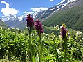
View of the Valley of Flowers
Location Chamoli District, Uttarakhand, India
Part of Nanda Devi and Valley of Flowers National Parks
Reference 335-002
Inscription1988 (12th Session)
Extensions2005
Area8,750 ha (33.8 sq mi)
Coordinates 30°43′48″N79°37′03″E / 30.73000°N 79.61750°E / 30.73000; 79.61750
India Uttarakhand relief map.svg
Red pog.svg
Location of Valley of Flowers National Park in Uttarakhand
India relief location map.jpg
Red pog.svg
Valley of Flowers National Park (India)
World location map (equirectangular 180).svg
Red pog.svg
Valley of Flowers National Park (Earth)

Valley of Flowers National Park is an Indian national park which was established in 1982. It is located in Chamoli in the state of Uttarakhand and is known for its meadows of endemic alpine flowers and the variety of flora. This richly diverse area is also home to rare and endangered animals, including the Asiatic black bear, [1] snow leopard, [1] musk deer, [1] brown bear, red fox [1] and blue sheep. Birds found in the park include Himalayan monal pheasant and other high-altitude birds. [2]

Contents

At 3,352 to 3,658 meters above sea level, the gentle landscape of the Valley of Flowers National Park complements the rugged mountain wilderness of Nanda Devi National Park to the east. [3] Together, they encompass a unique transition zone between the mountain ranges of the Zanskar and Great Himalayas. The park stretches over 87.50 km2 and is about 8 km long and 2 km wide. [2] It lies completely in the temperate alpine zone. Both parks are encompassed in the Nanda Devi Biosphere Reserve (223,674 ha) which is further surrounded by a buffer zone (5,148.57 km2). [4] Nanda Devi National Park Reserve is in the UNESCO World Network of Biosphere Reserves.

The park is open only during summer from June to October and is covered by heavy snow for the rest of the year. [1]

History

Lady Joan Margaret Legge's memorial grave. Margaretc.jpg
Lady Joan Margaret Legge's memorial grave.

Documented explorers

The place was little known to the outside world due to its inaccessibility. In 1931, Frank S. Smythe, Eric Shipton and R. L. Holdsworth, all British mountaineers, lost their way while returning from a successful expedition to Mt. Kamet and happened upon the valley, which was full of flowers. They were attracted to the beauty of the area and named it the "Valley of Flowers." Smythe later authored a book of the same name. [5]

In 1939, Lady Joan Margaret Legge, (21 February 1885 – 4 July 1939) a botanist deputed by the Royal Botanic Gardens, Kew, [2] arrived at the valley to study flowers and while traversing some rocky slopes to collect flowers, she slipped and died. [6] Her sister later visited the valley and erected a memorial near the spot. [3]

Prof. Chandra Prakash Kala, a botanist deputed by the Wildlife Institute of India, carried out a research study on the floristics and conservation of the valley for a decade, beginning in 1993. [7] He made an inventory of 520 alpine plants exclusively growing in this national park and authored two books – "The Valley of Flowers – Myth and Reality" and "Ecology and Conservation of the Valley of Flowers National Park, Garhwal Himalaya. [7] [8]

Timeline

1862: The Pushpawati River Valley was discovered by Col. Edmund Smyth;

1931: The valley visited by the climber Frank S. Smythe who wrote a book publicising the "Valley of Flowers";

1934: The upper Nanda Devi Sanctuary was reached and described by mountaineers Eric Shipton & Bill Tilman;

1936: Mountaineers Bill Tilman & Noel Odell climbed Nanda Devi;

1939: The basin established as the Nanda Devi Game Sanctuary by Government Order 1493/XIV- 28 of 7/01;

1962: Border disputes closed the area to traffic, altering the local economy;

1974–82: The sanctuary was opened to mountaineering, but the ensuing degradation led to its closure to all users;

1980: The park was established as Sanjay Gandhi National Park by Notification 3912/ XIV 3-35-80; grazing and mountaineering stopped;

1980: The Valley of Flowers was declared a national park by Government Order 4278/XIV-3-66-80 under the provisions of the Wildlife Protection Act of 1972, for the conservation of its flora;

1982: The park was renamed Nanda Devi National Park;

1988: The Nanda Devi National Biosphere Reserve established (223,674 ha) with the national park as core zone (62,462 ha) and a 514,857 ha buffer area surrounding both sites; restrictions were imposed on the rights of nearby villagers. Inscribed as a UNESCO World Heritage site; [9]

2000: The Biosphere Reserve extended by the government to 586,069 ha and the Valley of Flowers National Park was added as the second core zone (62,462 ha+ 8,750 ha, totalling core areas of 71,212 ha);

2004: The two core zones and buffer zone designated a UNESCO MAB reserve.

Geoclimatic

Location

Valley of Flowers, see trek in left-hand side and valley in front. Vof13082010.jpg
Valley of Flowers, see trek in left-hand side and valley in front.
One of the streams that cuts the trek route. Vof1 28.jpg
One of the streams that cuts the trek route.

Getting to the Valley of Flowers requires a trek of about 17 km (10.5 mi). The nearest major town is Joshimath [1] [10] in Garhwal, which has convenient road connections from Haridwar and Dehradun, both about 270 km (168 mi) south of Joshimath. From Delhi, one can take the train to Haridwar and then travel by bus to Govindghat via Rishikesh. [11] Govindghat is approximately 24 km before another important destination of Badrinath. It is also possible to drive from Delhi to Govindghat, a distance of about 500 km.

Govindghat is a small place close to Joshimath (around one hour driving distance), where the trek begins. From Govindghat, shared taxis up to 4 km and then a trek of less than 11 km (8.6 mi) brings trekkers to Ghangaria, a small settlement located about 3 km (about 2 mi) from the valley. One can also hire a porter, mule or helicopter to reach Ghangaria. The trek from Govindghat to Ghangaria is common to the Gurudwara Shri Hemkund Sahib Sikh Temple at Hemkund and a trekker is likely to find many Sikh pilgrims on the route. As one nears Ghangaria, one is greeted by fields of perfumed wild flowers, wild rose bushes and wild strawberries by the sides of the path. Visitors to the Valley of Flowers need to get a permit from the Forest Department, at Ghangaria. The permit is valid for three days. Only visiting and trekking are allowed during the day time. [1]

Visitors are not allowed to stay inside the National park and accommodation can be obtained at Ghangaria. [1] [12] The best time to visit is between July and early September, when the valley is full of flowers, just after the outbreak of monsoon. [1]

Geography

The Valley of Flowers is nestled in the Pushpawati river valley which is in the upper expanses of Bhyundar Ganga river near Joshimath in Garhwal region. The lower reaches of Bhyundar Ganga near Gobindghat are known as Bhyundar Valley. The Valley of Flowers, which lies between 30° 41' to 30° 48'N and 79° 33' to 79° 46'E, in the Pushpawati valley is 20 km northwest of Nanda Devi National Park across the wide valley of the Bhyundar Ganga. It is one of two hanging valleys lying at the head of the Bhyundar valley, [1] the other being the shorter Hemkund valley which runs parallel to Valley of Flowers some 10 km south. Valley of Flowers runs east-west approximately 15 km in length with average width of 6 km. A small tributary of Pushpawati river originates from Tipra glacier from Gauri Parbat in the east and flows through the Valley of Flowers.

The area lies on the Zanskar range of the Himalayas with the highest point in the national park being Gauri parbat at 6,719 m above sea level.

Climate

A scene from Valley of Flowers, Impatiens sulcata, This flower paints the Valley of Flowers in pink in the first week of August. Valley of flowers.JPG
A scene from Valley of Flowers, Impatiens sulcata, This flower paints the Valley of Flowers in pink in the first week of August.

Being an inner Himalayan valley, the Nanda Devi Basin has a distinctive micro-climate. Conditions are generally dry with low annual precipitation, but there is heavy monsoon rainfall from late June to early September. Prevailing mist and low cloud during the monsoon keeps the soil moist, hence the vegetation is lusher than is usual in the drier inner Himalayan valleys. From mid April to June temperatures are moderate to cool (19 °C maximum). The Valley of Flowers also has the micro-climate of an enclosed inner Himalayan valley, and is shielded from the full impact of the southwest summer monsoon by the Greater Himalaya range to its south. There is often dense fog and rain especially during the late summer monsoon. Both Basin and Valley are usually snow-bound for six to seven months between late October and late March, the snow accumulating deeper and at lower altitudes on the shadowed southern than on the northern side of the valleys. [13]

Ecology

Biodiversity

The Valley of Flowers is a high-altitude Himalayan valley that has long been acknowledged by renowned mountaineers, botanists, and in literature. It has been recognized internationally for over a century and is referenced in the Hindu religion. Local people have visited the valley since ancient times. [3] Indian yogis are known to have visited the valley for meditation. [14] The Valley of Flowers has many different colourful flowers, taking on various shades of colours as time progressed. [3]

The Valley of Flowers has gained importance as a region containing a diversity of alpine flora, representative of the Western Himalayan alpine shrub and meadows ecoregion. The rich diversity of species reflects the valley's location within a transition zone between the Zanskar and Great Himalayas ranges to the north and south, respectively, and between the Eastern Himalaya and Western Himalaya flora. A number of plant species are considered threatened. Several have not been recorded outside of Uttarakhand. Two have not been recorded in Nanda Devi National Park. The diversity of threatened species of medicinal plants is higher than has been recorded in other Indian Himalayan protected areas. The entire Nanda Devi Biosphere Reserve lies within the Western Himalayas Endemic Bird Area (EBA). The Valley of Flowers National Park is the second core zone of the Nanda Devi Biosphere Reserve. Seven restricted-range bird species are endemic to this part of the EBA.

Flora

Three types of sub-alpine zones

Pushpawati River rushing out of the Valley of Flowers. Pushpawati vof2.jpg
Pushpawati River rushing out of the Valley of Flowers.

The valley has three types of sub-alpine zones as follows: foothills alpine between 3,200 m and 3,500 m which is the upper height limit for trees, lower alpine between 3,500 m and 3,700 m, and higher alpine above 3,700 m. The habitats include valley bottom, river bed, small forests, meadows, eroded, scrubby and stable slopes, moraine, plateau, bogs, stone desert and caves. The lower surrounding hills in the buffer zone are thickly forested. The Forest Research Institute in 1992 recorded 600 species of angiosperms and 30 pteridophytes in the valley and surroundings, discovering 58 new records for the valley of which 4 were new for Himalayan state. Of these plants, 5 out of 6 species globally threatened are not found in Nanda Devi National Park or elsewhere in Uttarakhand: Aconitum falconeri , A. balfouri , Himalayan maple ( Acer caesium ), the blue Himalayan poppy ( Meconopsis aculeata ) and Saussurea atkinsoni . 31 species of rare and endangered categories were observed within the national park in 1998. [15] Further his studies report that the dominant family in Valley of Flowers is Asteraceae with 62 species. [16] 45 medicinal plants are used by local villagers and several species, such as Saussurea obvallata (brahmakamal) are collected as religious offerings to goddesses Nanda Devi and Sunanda Devi. [17] The site is designated a Centre of Plant Diversity. [16]

Characteristic of the sub-alpine zone are high altitude forests which help to retain moisture and snow and support a large number of floral and faunal communities. It is dominated by the uncommon Himalayan maple Acer caesium (VU), west Himalayan fir Abies pindrow , Himalayan white birch Betula utilis , and Rhododendron campanulatum with Himalayan yew Taxus wallichiana , Syringa emodi and Sorbus lanata . Some of the common herbs are Arisaema jacquemontii , Boschniakia himalaica , Corydalis cashmeriana , Polemonium caerulium , Impatiens sulcata , Geranium wallichianum , Galium aparine , Morina longifolia , Inula grandiflora , Nomochoris oxypetala , nemone rivularis , Pedicularis pectinata , P. bicornuta , Primula denticulate and Trillidium govanianum . [18] [19] In trampled areas where past livestock congregated, Himalayan knotweed Polygonum polystachium is a rampant weed.

Flowers

The flowers were surveyed and inventoried in 1987 by the Botanical Survey of India, in 1992 by the Forest Research Institute and in 1997 by the Wildlife Institute of India which found five species new to science.

Flowers mostly orchids, poppies, primulas, marigold, daisies and anemones carpet the ground. [10] Sub-alpine forests of birch and rhododendron cover parts of the park's area. A decade long study by C.P. Kala from 1993 onward concludes that the Valley of Flowers is endowed with 520 species of higher plants (angiosperms, gymnosperms and pteridophytes), of these 498 are flowering plants. The park has many species of medicinal plants including Dactylorhiza hatagirea , Picrorhiza kurrooa , Aconitum violaceum , Polygonatum multiflorum , Fritillaria roylei and Podophyllum hexandrum . [20] [21]

Fauna

Species diversity

The density of wild animals in the valley is not high, but all the animals found are rare or endangered. Prior to 2004, a total 13 species of mammals are recorded for the park by CP Kala [22] and its vicinity although only he sighted 9 species directly: northern plains gray langur Semnopithecus entellus, red giant flying squirrel Petaurista petaurista, Himalayan black bear Ursus thibetanus (VU), red fox Vulpes vulpes, Himalayan weasel Mustela sibirica, and Himalayan yellow-throated marten Martes flavigula, Himalayan goral Naemorhedus goral, Himalayan musk deer Moschus leucogaster, Indian spotted chevrotain Moschiola indica, Himalayan tahr Hemitragus jemlahicus (VU) and serow Capricornis sumatraensis (VU). The tahr is common, the serow, goral, musk deer and bharal, blue sheep are rare. [22]

Snow leopard. Uncia uncia.jpg
Snow leopard.

Predators, leopards and bears

A October 2004 faunal survey established the presence of snow leopard Panthera uncia (EN) in the national park. The common leopard Panthera pardus is reported from lower parts of the valley closer to the villages. Local people have also reported evidence of brown bear Ursus arctos and bharal or blue sheep Pseudois nayaur.

Reptiles

Among the reptiles, most often seen are the high altitude lizard Agama tuberculata , Himalayan ground skink Leiolopisma himalayana and Himalayan pit viper Gloydius himalayanus . Along with the flowers are wild bees and many species of butterfly which need to be more researched. A few of the more evident species are lime butterfly Papilio demoleus demoleus, common yellow swallowtail Papilio machaon , common Mormon Papilio polytes romulus, spangle Papilio protenor protenor and common blue apollo Parnassius hardwickei.

Birds

The area is within the West Himalayan Endemic Bird Area but there have been no surveys specific to the Valley. 114 species were seen in 1993 in Nanda Devi Park. Species frequently seen in the valley include lammergeier Gypaetus barbatus , Himalayan vulture Gyps himalayensis , Yellow-billed and Red-billed choughs Pyrrhocorax graculus and P. pyrrhocorax, koklass pheasant Pucrasia macrolopha , the nationally listed Himalayan monal pheasant Lophophorus impejanus, found in rhododendron thickets, scaly-bellied and yellownape woodpeckers Picus squamatus and P. flavinucha, great and blue-throated barbets Megalaima virens and M. asiatica, snow pigeon Columba leuconota and spotted dove Stigmatopelia chinensis.

Conservation

Conservation management

The park is administered by the Uttarakhand State Forestry Department, the national Ministry of Environment and Forests, India. There is no settlement in the national park and grazing in the area has been banned since 1983. The park is open only for 4 to 5 months during summer from June to October. [1]

Research nursery and seed bank

A research nursery and seed/rhizome/tuber bank for propagating rare plants and valuable medicinal herbs has been created at Musadhar near the entrance of the site. Rare and valuable medicinal plants are the subject of special programs. These include Aconitum heterophyllum, A. falconeri, Arnebia benthamii, Dactylorhiza hatagirea, Gymnadenia orchides, Megacarpaea polyandra, Picrorhiza kurrooa, Podophyllum hexandrum and Taxus wallichiana. Research plots have been set up to determine the best way to control the spread of the tall Himalayan knotweed Polygonum polystachium without damaging other plants or the surface of the soil. A first annual survey was conducted in 2004 and will be repeated annually.

See also

Related Research Articles

<span class="mw-page-title-main">Nanda Devi</span> Second-highest mountain in India

Nanda Devi is the second-highest mountain in India, after Kangchenjunga, and the highest located entirely within the country. Nanda Devi is the 23rd-highest peak in the world.

<i>Saussurea</i> Genus of flowering plants

Saussurea is a genus of about 300 species of flowering plants in the tribe Cardueae within the family Asteraceae, native to cool temperate and arctic regions of East Asia, Europe, and North America, with the highest diversity in alpine habitats in the Himalayas and East Asia. Common names include saw-wort and snow lotus, the latter used for a number of high altitude species in East Asia.

<span class="mw-page-title-main">Great Himalayan National Park</span> National park in Himachal Pradesh, India

The Great Himalayan National Park (GHNP) is a national park in India, located in Banjar sub-division of Kullu in the state of Himachal Pradesh. The park was established in 1984 and is spread over an area of 1171 km2; elevations within the park range between 1500 and 6000 m. The Great Himalayan National Park is a habitat to numerous flora and more than 375 fauna species, including approximately 31 mammals, 181 birds, 3 reptiles, 9 amphibians, 11 annelids, 17 mollusks and 127 insects. They are protected under the strict guidelines of the Wildlife Protection Act of 1972; hence any sort of hunting is not permitted.

<span class="mw-page-title-main">Pin Valley National Park</span> National park in India

Pin Valley National Park is a National park of India located in the Spiti Valley in the Lahaul and Spiti district, in the state of Himachal Pradesh. It is located in far northern India. It is part of Cold Desert.

<span class="mw-page-title-main">Hemis National Park</span> National Park in Ladakh, India

Hemis National Park is a high-elevation national park in Ladakh, India. Globally famous for its snow leopards, it is believed to have the highest density of them in any protected area in the world. It is the only national park in India that is north of the Himalayas, the largest notified protected area in India and is the second largest contiguous protected area, after the Nanda Devi Biosphere Reserve and surrounding protected areas. The park is home to a number of species of endangered mammals, including the snow leopard. Hemis National Park is India's protected area inside the Palearctic realm, outside the Changthang Wildlife Sanctuary northeast of Hemis, and the proposed Tso Lhamo Cold Desert Conservation Area in North Sikkim.

The Nanda Devi National Park or Nanda Devi Biosphere Reserve, established in 1982 is a national park situated around the peak of Nanda Devi in Chamoli Garhwal district of Uttarakhand, in northern India. The entire park lies at an elevation of more than 3,500 m (11,500 ft) above mean sea level.

<span class="mw-page-title-main">Makalu Barun National Park</span>

Makalu Barun National Park is a national park in the Himalayas of Nepal that was established in 1992 as the eastern extension of Sagarmatha National Park. It is the world's only protected area with an elevation gain of more than 8,000 m (26,000 ft) enclosing tropical forest as well as snow-capped peaks. It covers an area of 1,500 km2 (580 sq mi) in the Solukhumbu and Sankhuwasabha districts, and is surrounded by a bufferzone to the south and southeast with an area of 830 km2 (320 sq mi).

<span class="mw-page-title-main">Gurdwara Hemkund Sahib</span> Gurdwara in Uttarakhand, India

Gurdwara Hemkund Sahib is a Sikh place of worship (gurdwara) and pilgrimage site in Chamoli district, Uttarakhand, India. It is devoted to Guru Gobind Singh (1666–1708), the tenth Sikh Guru, and finds mention in Dasam Granth. With its setting of a glacial lake surrounded by seven mountain peaks, each adorned by a Nishan Sahib on its cliff, it is according to the Survey of India located in the Garhwal Himalaya at an elevation of 4,572 metres. It is approached from Govindghat on the Rishikesh-Badrinath highway. The main town near Gobindghat is Joshimath. The elevation of the lake at Hemkund is approximately 15,000 feet.

<span class="mw-page-title-main">Ghangaria</span> Village in Uttarakhand, India

Ghangaria also known as "Gobind Dham" is a small village on the way to Hemkund Sahib, a popular pilgrimage site for Sikhs which is about 6 km from here and the Valley of Flowers, a national park known for its variety of flowers about 5 km from here. It is located in the northern Himalayan ranges at an altitude of 3049 meters in Uttarakhand state of India.

India is home to a large variety of wildlife. It is a biodiversity hotspot with various ecosystems ranging from the Himalayas in the north to the evergreen rainforests in the south, the sands of the west to the marshy mangroves of the east. India lies within the Indomalayan realm and is home to about 7.6% of mammal, 14.7% of amphibian, 6% of bird, 6.2% of reptilian, and 6.2% of flowering plant species. India's forests contain about 500 species of mammals and more than 1300 bird species.

<span class="mw-page-title-main">Western Himalayan alpine shrub and meadows</span>

The Western Himalayan alpine shrub and meadows is a montane grasslands and shrublands ecoregion of Nepal, India, and Tibet, which lies between the tree line and snow line in the western portion of the Himalaya Range.

<span class="mw-page-title-main">Eastern Himalayan alpine shrub and meadows</span> Ecoregion in the Eastern Himalayas

The Eastern Himalayan alpine shrub and meadows is a montane grasslands and shrublands ecoregion of Bhutan, China, India, Myanmar, and Nepal, which lies between the tree line and snow line in the eastern portion of the Himalaya Range.

Kedarnath Wild Life Sanctuary, also called the Kedarnath Musk Deer Sanctuary, is a wildlife sanctuary declared under Wildlife Protection Act, 1972 and located in Uttarakhand, India. Its alternate name comes from its primary purpose of protecting the endangered Himalayan musk deer. Consisting of an area of 975 km2 (376 sq mi), it is the largest protected area in the western Himalayas.It is famous for alpine musk deer, Himalayan Thar, Himalayan Griffon, Himalayan Black bear, Snow Leopard and other flora park and fauna. It is internationally important for the diversity of its flora and fauna.

<span class="mw-page-title-main">Geography of Uttarakhand</span>

Uttarakhand has a total geographic area of 53,483 km2, of which 86% is mountainous and 65% is covered by forest. Most of the northern parts of the state are part of Greater Himalaya ranges, covered by the high Himalayan peaks and glaciers, while the lower foothills were densely forested till denuded by the British log merchants and later, after independence, by forest contractors. Recent efforts in reforestation, however, have been successful in restoring the situation to some extent. The unique Himalayan ecosystem plays host to many animals, plants and rare herbs. Two of India's great rivers, the Ganges and the Yamuna take birth in the glaciers of Uttarakhand, and are fed by myriad lakes, glacial melts and streams.

<span class="mw-page-title-main">Pushpawati River</span> River in India

Pushpawati River flows through the Valley of Flowers in Chamoli district in Garhwal region of the Indian state of Uttarakhand.

The ecology of the Himalayas varies with climate, rainfall, altitude, and soils. The climate ranges from tropical at the base of the mountains to permanent ice and snow at the highest elevations. The amount of yearly rainfall increases from west to east along the southern front of the range. This diversity of climate, altitude, rainfall and soil conditions supports a variety of distinct plant and animal species, such as the Nepal gray langur

<span class="mw-page-title-main">Chandra Prakash Kala</span> Indian ecologist and professor

Chandra Prakash Kala is an Indian ecologist and professor. His research interests include alpine ecology, conservation biology, indigenous knowledge systems, ethnobotany and medicinal aromatic plants. He is an assistant professor in the faculty area of Ecosystem and Environment Management at the Indian Institute of Forest Management.

<i>Sinopodophyllum</i> Genus of flowering plants belonging to the barberry family

Sinopodophyllum is an herbaceous perennial plant in the family Berberidaceae, described as a genus in 1979. It includes only one known species, Sinopodophyllum hexandrum, native to Afghanistan, Bhutan, northern India, Kashmir, Nepal, Pakistan, and western China. Common names include Himalayan may apple and Indian may apple.

Saf Minal is a mountain of Garhwal Himalaya in Uttarakhand India. Saf Minal standing majestically at 6911 meter 22674 feet. It's the 21st highest located entirely within the uttrakhand India. Nanda Devi, is the highest mountain in this category and 50th highest peak in India. Saf Minal is the 332nd highest peak in the world. Saf Minal falls on the edge of the Northern Nanda Devi National Park.

<span class="mw-page-title-main">Nilgiri Parbat</span> Mountain in Uttarakhand, India

Nilgiri Parbat is a mountain of the Garhwal Himalaya in Uttarakhand India and rises to an elevation of 6,474 metres (21,240 ft) with a prominence is 893 metres (2,930 ft). It is 91st highest located entirely within Uttarakhand. Nanda Devi, is the highest mountain in this category. It lies 6.7 km NW of Ratabon and 9.4 km south of Deoban. It lies 6.3 km SSW of Mandir Parbat its nearest higher neighbor. It is located 12.7 km NNW of Hathi Parbat 6,727 metres (22,070 ft) and 11.2 km north lies Mana Peak 7,272 metres (23,858 ft).

References

  1. 1 2 3 4 5 6 7 8 9 10 11 Gopal K. Bhargava; S.C. Bhatt, eds. (2006). Uttaranchal. Delhi: Kalpaz publ. pp. 208, 209. ISBN   9788178353838.
  2. 1 2 3 Richard W. Butler; Douglas G. Pearce, eds. (1999). Tourism Development. London: Routledge. p. 205. ISBN   9780203380307.
  3. 1 2 3 4 N. Ulysses and Tabish, Thingnam Girija. "Trek to Valley of Flowers". Flowers of India. Retrieved 5 June 2013.
  4. "World Conservation Monitoring Centre". Archived from the original on 10 July 1997. Retrieved 20 July 2018.
  5. Colonel Frank Smythe – Francis Sydney Smythe Archived 30 May 2013 at the Wayback Machine , 1900–1949
  6. "Valley of Flowers". sikhnet.com. Retrieved 5 June 2013.
  7. 1 2 Chandra Prakash Kala. "How Valley of Flowers got World Heritage Site tag". Down to Earth. Retrieved 17 October 2012.
  8. Chandra Prakash Kala. "Paradise under fire". Down to Earth. Retrieved 15 June 2002.
  9. Centre, UNESCO World Heritage. "Nanda Devi and Valley of Flowers National Parks". UNESCO World Heritage Centre. Retrieved 7 April 2022.
  10. 1 2 Valley of Flowers, Article by Asif N Khan in Hornbill April–June 2015 P.p. 10-15, Bombay Natural History Society.
  11. "Valley of Flowers National Park". Sanctuary Asia Magazine. Archived from the original on 24 June 2013. Retrieved 8 June 2013.
  12. "ET Recommendations: 5 best places to enjoy monsoon, movie to watch, gadget to buy". The Times of India . 22 July 2012. Archived from the original on 21 February 2013. Retrieved 5 June 2013.
  13. Lamba, B. 1987. Status survey report of fauna: Nanda Devi National Park. Records of the Zoological. Survey of India Occasional Paper No. 103. 50 pp
  14. Tigunait, Rajmani (2001). At the eleventh hour : the biography of Swami Rama . Honesdale, Pa.: Himalayan Institute. p.  88. ISBN   9780893892128. valley of flowers.
  15. Kala, CP 1998. Ecology and Conservation of Alpine Meadows in the Valley of Flowers National Park, Garhwal Himalaya. Forest Research Institute, Dehradun
  16. 1 2 "Valley of Flowers: World Heritage Site" (PDF). Archived from the original (PDF) on 17 October 2018. Retrieved 21 January 2013.
  17. Kala, C.P. 2004. Pastoralism, plant conservation, and conflicts on proliferation of Himalayan knotweed in high altitude protected areas of the Western Himalaya, India. Biodiversity and Conservation, 13 (5): 985–995.
  18. Kala, C.P. (2005). "A multifaceted review on the biodiversity conservation of the Valley of Flowers National Park, India". International Journal of Biodiversity Science and Management. 1 (1): 25–32. doi: 10.1080/17451590509618077 . S2CID   84896241.
  19. Kala, C.P. (2005) Indigenous uses, population density, and conservation of threatened medicinal plants in protected areas of the Indian Himalayas. Conservation Biology, 19 (2): 368–378.
  20. Kala, C.P. (2005). "The Valley of Flowers; A newly declared World Heritage Site" (PDF). Current Science. 89 (6): 919–920. Archived from the original (PDF) on 17 October 2018. Retrieved 21 January 2013.
  21. Kala, C.P. 2004. The Valley of Flowers; Myth and Reality. International Book Distributors, Dehradun, India
  22. 1 2 Kala, C.P. (2004) Distribution pattern and conservation status of mammals and birds in the Valley of Flowers National Park and its vicinity, Uttaranchal. Himalayan Biosphere Reserves, 6: 91–102

Further reading