The Rhine is one of the major European rivers. The river begins in the Swiss canton of Graubünden in the southeastern Swiss Alps. It forms part of the Swiss-Liechtenstein, Swiss-Austrian, and Swiss-German borders. After that the Rhine defines much of the Franco-German border, after which it flows in a mostly northerly direction through the German Rhineland. Finally in Germany, the Rhine turns into a predominantly westerly direction and flows into the Netherlands where it eventually empties into the North Sea. It drains an area of 9,973 sq km and its name derives from the Celtic Rēnos. There are also two German states named after the river, North Rhine-Westphalia and Rhineland-Palatinate.

The Brahmaputra is a trans-boundary river which flows through Tibet (China), Northeastern India, and Bangladesh. It is known as Brahmaputra or Luit in Assamese,Yarlung Tsangpo in Tibetan, the Siang/Dihang River in Arunachali and Jamuna River in Bengali. It is the 9th largest river in the world by discharge, and the 15th longest.
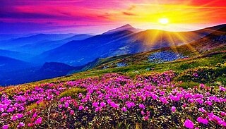
Valley of Flowers National Park is an Indian national park which was established in 1982. It is located in Chamoli in the state of Uttarakhand and is known for its meadows of endemic alpine flowers and the variety of flora. This richly diverse area is also home to rare and endangered animals, including the Asiatic black bear, snow leopard, musk deer, brown bear, red fox and blue sheep. Birds found in the park include Himalayan monal pheasant and other high altitude birds.
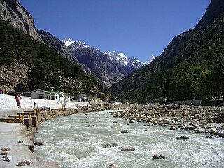
The Bhāgīrathī is a turbulent Himalayan river in the Indian state of Uttarakhand, and one of the two headstreams of the Ganges, the major river of Northern India and the holy river of Hinduism. In the Hindu faith, mythology, and culture, the Bhagirathi is considered the source stream of the Ganges. However, in hydrology, the other headstream, Alaknanda, is considered the source stream on account of its great length and discharge. The Bhagirathi and Alaknanda join at Devprayag in Garhwal and are thereafter known as the Ganges.

Chamoli district is a district of the Uttarakhand state of India. It is bounded by the Tibet region to the north, and by the Uttarakhand districts of Pithoragarh and Bageshwar to the east, Almora to the south, Pauri Garhwal to the southwest, Rudraprayag to the west, and Uttarkashi to the northwest. The administrative headquarters of Chamoli district is in Gopeshwar.

The Alaknanda is a turbulent Himalayan river in the Indian state of Uttarakhand and one of the two headstreams of the Ganges, the major river of Northern India and the holy river of Hinduism. In hydrology, the Alaknanda is considered the source stream of the Ganges on account of its greater length and discharge; however, in Hindu tradition and culture, the other headstream, the Bhagirathi, is considered the source stream.
The Nanda Devi National Park or Nanda Devi Biosphere Reserve, established in 1982 is a national park situated around the peak of Nanda Devi in Chamoli Garhwal district of Uttarakhand, in northern India. The entire park lies at an elevation of more than 3,500 m (11,500 ft) above mean sea level.

The state of Himachal Pradesh is spread over an area 55,673 km2 (21,495 sq mi) and is bordered by Jammu and Kashmir and Ladakh on the north, Punjab on the southwest, Haryana on the south, Uttarakhand on the southeast, a small border with Uttar Pradesh in the south, and Tibet on the east. Entire Himachal Pradesh lies in the mountainous Himalaya region, rich in natural resources
Ramganga is a tributary of the river Ganges, originating in Uttarakhand state, India.

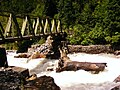
The Dhauliganga is a turbulent Himalayan river which rises in the border regions of India and China and flows south into the Garhwal region of Uttarakhand, India. It joins the Alaknanda, the major source stream of the Ganges river.

Gori Ganga is a river in the Munsiari tehsil of the Pithoragarh District, part of the state of Uttarakhand in northern India. Its principal source is the Milam Glacier, just northeast of Nanda Devi along with the Glaciers of the Ralam River, and the Pyunshani and Uttari & Dakshini Balati Glaciers that lie on the western face of the Panchachuli Peaks.

The Wutach is a river, 91 kilometres long, in the southeastern part of the Black Forest in the German state of Baden-Württemberg. It is a right-hand tributary of the Rhine. In its lower reaches it flows for about 6 kilometres along the border with the canton of Schaffhausen, Switzerland.

Uttarakhand has a total geographic area of 53,483 km2, of which 86% is mountainous and 65% is covered by forest. Most of the northern parts of the state are part of Greater Himalaya ranges, covered by the high Himalayan peaks and glaciers, while the lower foothills were densely forested till denuded by the British log merchants and later, after independence, by forest contractors. Recent efforts in reforestation, however, have been successful in restoring the situation to some extent. The unique Himalayan ecosystem plays host to many animals, plants and rare herbs. Two of India's great rivers, the Ganges and the Yamuna take birth in the glaciers of Uttarakhand, and are fed by myriad lakes, glacial melts and streams.

The Trishuli River is one of the major tributaries of the Narayani River basin in central Nepal. The river is formed by the merger of Kyirong Tsangpo and Lende Khola originating in Gyirong County of Tibet, which join together near the Rasuwa Gadhi on the Nepal–Tibet border. The valley of the river provided the traditional trade route between the Kathmandu Valley and Tibet.
The Panjang River, a tributary of the Karnali, flows through north-western Nepal.

The Shipton–Tilman Nanda Devi expeditions took place in the 1930s. Nanda Devi is a Himalayan mountain in what was then the Garhwal District in northern India, just west of Nepal, and at one time it was thought to be the highest mountain in the world.

Nayar River is a perennial, non-glacial river in the North Indian state of Uttarakhand. The river system is one of the largest non-glacial perennial rivers in the state, second only to Ramganga (West) and flows entirely in the district of Pauri Garhwal. The two main branches of the river, Nayar East and Nayar West along with Ramganga river, rise in the dense forests and high meadows of Dudhatoli and merge to form Nayar roughly one kilometre ahead of Satpuli. Satpuli is a town on the left bank of Nayar East river.

Kalanka is a mountain of the Garhwal Himalayas in Uttarakhand, India. Kalanka stands at 6,931 metres (22,740 ft). It's the 20th highest located entirely within the Uttrakhand. Nanda Devi is the highest mountain in this category. Kalanka is the 48th highest peak in India and 319th highest peak in the world. Southern side of Kalanka falls under Nanda Devi National Park.

Nilgiri Parbat is a mountain of the Garhwal Himalaya in Uttarakhand India and rises to an elevation of 6,474 metres (21,240 ft) with a prominence is 893 metres (2,930 ft). It is 91st highest located entirely within Uttarakhand. Nanda Devi, is the highest mountain in this category. It lies 6.7 km NW of Ratabon and 9.4 km south of Deoban. It lies 6.3 km SSW of Mandir Parbat its nearest higher neighbor. It is located 12.7 km NNW of Hathi Parbat 6,727 metres (22,070 ft) and 11.2 km north lies Mana Peak 7,272 metres (23,858 ft).

The Isel is a 57.3 kilometres (35.6 mi) glacier-fed river in East Tyrol, Austria. The river flow varies with daily and seasonal temperature changes, and the riverbed is constantly shifting, creating a unique environment. The river's course runs along a geological fault running from NW to SE. It held a glacier during the last ice age, which has left boulders and gravel along the valley. There have been various proposals to dam and divert the water for use in generating hydroelectricity which have been opposed by environmentalists. Since 2015 the river has been designated a Natura 2000 site, which offers some protection. There is a hiking trail along the river, and it is known for excellent whitewater rafting conditions.