Badrinath is a town and nagar panchayat in Chamoli district in the state of Uttarakhand, India. It is a Hindu holy place, and is one of the four sites in India's Char Dham pilgrimage. It is also part of India's Chota Char Dham pilgrimage circuit and gets its name from the Badrinath Temple.

Chamoli district is a district of the Uttarakhand state of India. It is bounded by the Tibet region to the north, and by the Uttarakhand districts of Pithoragarh and Bageshwar to the east, Almora to the south, Pauri Garhwal to the southwest, Rudraprayag to the west, and Uttarkashi to the northwest. The administrative headquarters of Chamoli district is in Gopeshwar.

The Alaknanda is a turbulent Himalayan river in the Indian state of Uttarakhand and one of the two headstreams of the Ganges, the major river of Northern India and the holy river of Hinduism. In hydrology, the Alaknanda is considered the source stream of the Ganges on account of its greater length and discharge; however, in Hindu tradition and culture, the other headstream, the Bhagirathi, is considered the source stream.

Devprayag is a town and a nagar panchayat, near New Tehri city in Tehri Garhwal District in the state of Uttarakhand, India, and is the final one of the Panch Prayag of Alaknanda River where Alaknanda meets the Bhagirathi river and both rivers thereafter flow on as the Ganges river or Ganga.

Karnaprayag is a town and municipal board in the Chamoli District in the Indian state of Uttarakhand. Karnaprayag is one of the Panch Prayag of Alaknanda River, situated at the confluence of the Alaknanda and Pindar River.

Rudraprayag is a city and a municipality in Rudraprayag district in the Indian state of Uttarakhand. Rudraprayag is one of the Panch Prayag of Alaknanda River, the point of confluence of rivers Alaknanda and Mandakini. Kedarnath, a Hindu holy city is located 86 km from Rudraprayag. The man-eating Leopard of Rudraprayag hunted and written about by Jim Corbett dwelled here.

Nilkantha is a major peak of the Garhwal division of the Himalayas, in the Uttarakhand region of the Indian state of Uttarakhand. Although substantially lower than the highest peaks of the region, it towers dramatically over the valley of the Alaknanda River and rises 3,474 metres (11,398 ft) above the Hindu pilgrimage site of Badrinath, only 9 km (6 mi) to the east. Frank Smythe described the peak as "second only to Siniolchu in Himalayan beauty."
Tungnath (IAST:tuņgnāth) is one of the highest Shiva temples in the world and is the highest of the five Panch Kedar temples located in the Rudraprayag district, in the Indian state of Uttarakhand. The Tungnath mountains form the Mandakini and Alaknanda river valleys. It is located at an altitude of 3,690 m (12,106 ft), and just below the peak of Chandrashila. It has a rich legend linked to the Pandavas, heroes of the Mahabharata epic.

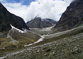
Balakun is a Himalayan peak situated in the Chamoli district of Uttarakhand state of India. The Balakun peak has the summit at an altitude of 6,471 m (21,230 ft) in the Garhwal Himalayas. Balakun Peak is located 16 km from Badrinath. Balakun is situated north west to Badrinath. Balakun is situated between Bhagirathi Kharak glacier and Satopanth glacier. The peak is situated north east of Nilkanth peak. The Alaknanda river originates from below this peak by the melting of these two glaciers at an altitude of 3,641 m (11,946 ft). The two glaciers rise from the eastern slopes of Chaukhamba (7140 m) peak and wrap around the Balakun peak. Balakun is situated north of Kunaling (5471 m) and south of the Arwa Group. The peak was first climbed in 1973 a by six-man team of ITBP led by Hukum Singh.

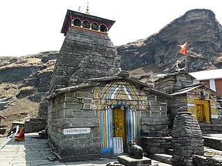
Kalpeshwar is a Hindu temple dedicated to Shiva located at an elevation of 2,200 m (7,217.8 ft) in the picturesque Urgam valley in the Garhwal region of Uttarakhand state in India. The temple's ancient legend linked to the Pandavas, heroes of the epic Mahabharata, is the fifth temple of the Panch Kedar of Shiva's five anatomical divine forms; the other four temples in the order of their worship are Kedarnath, Rudranath, Tungnath and Madhyamaheshwar temples; all in the Kedar Khand region of the Garhwal Himalayas. Kalpeshwar is the only Panch Kedar temple accessible throughout the year. At this small stone temple, approached through a cave passage, the matted tress (jata) of Lord Shiva is worshipped. Hence, Lord Shiva is also called as Jatadhar or Jateshwar. Earlier it was approachable only by 12 km (7.5 mi) trek from the nearest road head of Helang on the Rishikesh-Badrinath road but now the road goes up to Devgram village from where the trek now is just 300 metres. This road is good for bikes or cars with good ground clearance as it is a half-paved road which may get damaged during monsoons. Small cars can be taken except in monsoons.

Panch Prayag is an expression in Hindu religious ethos, specifically used to connote the five sacred river confluences in the Garhwal Himalayas in the state of Uttarakhand, India. The five prayags - prayag meaning "place of confluence of rivers" in Sanskrit - also termed as "Prayag pentad" are Vishnuprayag, Nandaprayag, Karnaprayag, Rudraprayag and Devprayag, in the descending flow sequence of their occurrence.

Vasudhara Falls is a waterfall situated near Badrinath, in Uttarakhand, India.
Mana is a village in the district of Chamoli in the Indian state of Uttarakhand, located at an altitude of 3,200 meters {10,500 feet}. It is located on the northern terminus of National Highway 7, Mana is the first village before the Mana Pass and is 26 kilometres from the border of India and Tibet. The village is at a distance of about 3 km from the Hindu Pilgrimage Badrinath and the two places are culturally connected with each other.
Uttarakhand is a state in the northern part of India. It is often referred to as the "Devbhumi" due to its religious significance and numerous Hindu temples and pilgrimage sites found throughout the state. As a result, religious tourism forms a major portion of the tourism in the state. Uttarakhand is known for the natural environment of the Himalayas. 2019 Tourist Arrivals Domestic – 40,000,000 per/year and Foreigner – 150,000 per year. Tourism business in Uttarakhand generated ₹ 23,000 crores during 2013–14.

Saraswati River is a tributary of Alaknanda River flowing in Uttarakhand State, India. It joins Alaknanda River at Keshav Prayag, near Mana village, Badrinath. The confluence of rivers Alaknanda and Bhagirathi at Devprayag in the state of Uttarakhand, forms and flows as river Ganga or The Ganges from the point forward. A natural stone bridge, named "Bhim Pul", lays across flowing Saraswati river, making a passage towards Vasudhara falls and Satopanth Lake. It is believed by locals that Bhim Pul is a rock bridge founded by Bhima of Mahabharatha, to help Draupadi to cross the rivulet.
Janhukut is a mountain of Garhwal Himalaya in Uttarakhand India. Janhukut standing majestically at 6805 meter. It's the 31st highest located entirely within the uttrakhand India. Nanda Devi, is the highest mountain in this category. Janhukut is the 473rd highest peak in the world.
Chandra Parbat I is a mountain of the Garhwal Himalaya in Uttarakhand, India. Chandra Parbat I standing majestically at 6,739 metres (22,110 ft). It is 42nd highest located entirely within the Uttrakhand. Nanda Devi, is the highest mountain in this category. Chandra Parbat I lies on the eastern bank of the Suralaya Glacier. It is located in between Chandra II and Chandra III (South). It is located 4.9 km NE of Satopanth 7,075 metres (23,212 ft) and 8 km west lies Vasuki South 6,702 metres (21,988 ft). On the 7.4 km SWS lies the Swachhand Peak 6,721 metres (22,051 ft) and Bhgirathi Massif on the west side.
Satopanth South West also called P. 6770 is a mountain of the Garhwal Himalaya in Uttarakhand, India. The elevation of Satopanth south west is 6,770 metres (22,211 ft) and its prominence is 195 metres (640 ft). It is 40th highest located entirely within the Uttrakhand. Nanda Devi, is the highest mountain in this category. It lies in the same connecting ridge that joins Satopanth and Bhagirathi Parbat I. It lies 1.8 km SW of Satopanth. Its nearest higher neighbor Satopanth 7,075 metres (23,212 ft). It is located 3.4 km SE of Vasuki South 6,702 metres (21,988 ft) and 5.2 km NNW lies Bhagirathi I 6,856 metres (22,493 ft).
Vasuki Parbat South is a mountain of the Garhwal Himalaya in Uttarakhand, India. The elevation of Vasuki Parbat South is 6,702 metres (21,988 ft) and its prominence is 280 metres (919 ft). It is 49th highest located entirely within the Uttrakhand. Nanda Devi, is the highest mountain in this category. It lies 1.6 km south of Vasuki Parbat its nearest higher neighbor 6,792 metres (22,283 ft) and 2.7 km east of Bhagirathi Parbat I 6,856 metres (22,493 ft). It is located 4.6 km SE of Bhagirathi Parbat II 6,512 metres (21,365 ft) and 4.1 km SE lies Satopanth 7,075 metres (23,212 ft).

Kalindi is a mountain of the Garhwal Himalaya in Uttarakhand India. The elevation of Kalindi is 6,102 metres (20,020 ft). It lies 1.1 km North of Avalanche Peak (India) 6,196 metres (20,328 ft) its nearest higher neighbor. Mana Parbat II 6,771 metres (22,215 ft) lies 4.2 km NNW and it is 6.1 km NNE of Chandra Parbat I 6,739 metres (22,110 ft).