
Chamoli district is a district of the Uttarakhand state of India. It is bounded by the Tibet region to the north, and by the Uttarakhand districts of Pithoragarh and Bageshwar to the east, Almora to the south, Pauri Garhwal to the southwest, Rudraprayag to the west, and Uttarkashi to the northwest. The administrative headquarters of Chamoli district is in Gopeshwar.

The Alaknanda is a Himalayan river in the Indian state of Uttarakhand and one of the two headstreams of the Ganges, the major river of Northern India and the holy river of Hinduism. In hydrology, the Alaknanda is considered the source stream of the Ganges on account of its greater length and discharge; however, in Hindu tradition and culture, the other headstream, the Bhagirathi, is considered the source stream.

Devprayag is a town and a nagar panchayat (municipality) in Tehri Garhwal District in the state of Uttarakhand, India, and is the final one of the Panch Prayag of Alaknanda River where Alaknanda meets the Bhagirathi river and both rivers thereafter flow on as the Ganges river or Ganga.
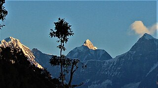
The Gangotri Group of mountains is a subdivision of the Garhwal Himalaya in the northern Indian state of Uttarakhand. It rings the Gangotri Glacier, and contains peaks that are notable either for their religious significance to Hindus, for their difficult climbing routes, or both. Climbs on three of the peaks have resulted in the awarding of the prestigious climbing award, the Piolet d'Or.

Chaukhamba is a mountain massif in the Gangotri Group of the Garhwal Himalaya. Its main summit, Chaukhamba I, is the highest peak in the group. It lies at the head of the Gangotri Glacier and forms the eastern anchor of the group. It is located in the northern Indian state of Uttarakhand, west of the Hindu holy town of Badrinath.

The Satopanth glacier is situated in the Indian state of Uttarakhand. River Alaknanda has it origin in Satopanth glacier. The glacier is one of the tourists favorite glaciers of Uttarakhand. Mountaineers consider it somewhat challenging to scale.

Vasudhara Falls is a waterfall situated near Badrinath, in Uttarakhand, India.

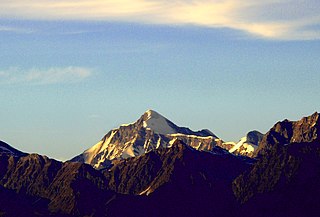
Sri Kailash is a mountain in Uttarakhand, India, the 47th highest located entirely within India. Nanda Devi, is the highest mountain in this category. Sri Kailash 204th highest peak in the world. The summit is 6932 meter or 22744 feet. It is the fourth highest mountain in the Gangotri region. The three above peaks in this region are Chaukhamba (7134m), Satopanth (7075m), Kedarnath (6940m). It is situated at the head of The Raktvarn Glacier.

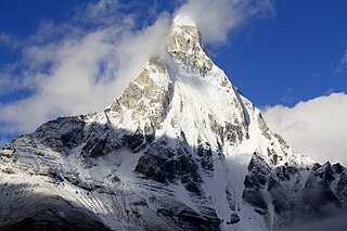
Bhagirathi Parbat I is a mountain in Uttarakhand India, Its highest peak in the Bhagirathi Massif. It's the 62nd highest located entirely within the India. Nanda Devi, is the highest mountain in this category. Bhagirathi Parbat I is 393rd highest peak in the world. The summits is 6856 meter or 22493 feet. It was first climbed by a Japanese team in 1980.

Bhagirathi Parbat II is a mountain in Uttarakhand India. It's the 85th highest located entirely within the Uttarakhand India. Nanda Devi, is the highest mountain in this category. Its second highest peak in the Bhagirathi Massif. The summits is 6512 meter or 21365 feet. It was first climbed by Austrians Edi Ellmauthaler and Toni Messner in 1933.
Janhukut is a mountain of Garhwal Himalaya in Uttarakhand India. Janhukut standing majestically at 6805 meter. It's the 31st highest located entirely within the uttrakhand India. Nanda Devi, is the highest mountain in this category. Janhukut is the 473rd highest peak in the world.

Swachhand is a mountain of the Garhwal Himalayas in Uttarakhand, India. Swachhand is 6,721 metres (22,051 ft) high. Its peak is the 46th highest located entirely within the Uttrakhand. Nanda Devi is the highest mountain in this category. Swachhand lies between the Satopanth 7,075 metres (23,212 ft) NNW and Janhukut 6,805 metres (22,326 ft) SSE. It's neighbour Janhukut peaks at 3.8 km SSE. It is located 8.9 km NW of Chaukhamba I 7,138 metres (23,419 ft) and 8.9 km NW lies Bhagirathi I 6,856 metres (22,493 ft).

Mandani Parbat is a mountain of the Garhwal Himalaya in Uttarakhand India.The elevation of Mandani Parbat is 6,193 metres (20,318 ft) and its prominence is 535 metres (1,755 ft). It is joint 140th highest located entirely within the Uttrakhand. Nanda Devi, is the highest mountain in this category. It lies between Chaukhamba IV, 6,854 metres (22,487 ft) and Sumeru Parbat, 6,351 metres (20,837 ft). Its nearest higher neighbor Chaukhamba IV lies 5.5 km east. It is located 8.4 km SE of Sumeru Parbat and 6.5 km NE lies Janhukut 6,829 metres (22,405 ft).
Satopanth South West also called P. 6770 is a mountain of the Garhwal Himalaya in Uttarakhand, India. The elevation of Satopanth south west is 6,770 metres (22,211 ft) and its prominence is 195 metres (640 ft). It is 40th highest located entirely within the Uttrakhand. Nanda Devi, is the highest mountain in this category. It lies in the same connecting ridge that joins Satopanth and Bhagirathi Parbat I. It lies 1.8 km SW of Satopanth. Its nearest higher neighbor Satopanth 7,075 metres (23,212 ft). It is located 3.4 km SE of Vasuki South 6,702 metres (21,988 ft) and 5.2 km NNW lies Bhagirathi I 6,856 metres (22,493 ft).
Jogin I is a mountain of the Garhwal Himalaya in Uttarakhand India.The elevation of Jogin I is 6,465 metres (21,211 ft) and its prominence is 843 metres (2,766 ft). It is 94th highest located entirely within the Uttrakhand. Nanda Devi, is the highest mountain in this category. It lies 5.4 km east of Gangotri III and 7.4 km west of Bhrigupanth 6,772 metres (22,218 ft). It lies 2.2 km South of Jogin II. Its nearest higher neighbor is Gangotri III 6,577 metres (21,578 ft). It is located 6.9 km NW of Thalaysagar 6,904 metres (22,651 ft) and 8.8 km NW lies Gangotri I 6,682 metres (21,923 ft).
Jogin II is a mountain of the Garhwal Himalaya in Uttarakhand India.The elevation of Jogin II is 6,342 metres (20,807 ft) and its prominence is 259 metres (850 ft). It is 110th highest located entirely within the Uttrakhand. Nanda Devi, is the highest mountain in this category. It lies 6.2 km east of Gangotri III and 7 km west of Bhrigupanth 6,772 metres (22,218 ft). It lies 2.2 km north of Jogin I. Its nearest higher neighbor is Jogin I 6,465 metres (21,211 ft). It is located 7.2 km NW of Thalay Sagar 6,904 metres (22,651 ft) and 8.5 km NW lies Gangotri I 6,682 metres (21,923 ft).
Jogin III is a mountain of the Garhwal Himalaya in Uttarakhand, India. The elevation of Jogin III is 6,116 metres (20,066 ft). It is 155th highest located entirely within the Uttrakhand. Nanda Devi, is the highest mountain in this category.

Manda I is a mountain of the Garhwal Himalaya in Uttarakhand India also called Manda. The elevation of Manda I is 6,510 metres (21,358 ft) and its prominence is 226 metres (741 ft). It is joint 86th highest located entirely within the Uttrakhand. Nanda Devi, is the highest mountain in this category. It lies 1.6km north of Manda II 6,568 metres (21,549 ft) and 3.9km north of Manda III 6,529 metres (21,421 ft). It lies 7.8km NE of Jogin II 6,342 metres (20,807 ft). It is located 6.6km north of Bhrigupanth 6,772 metres (22,218 ft) and 9.6km SW lies Jogin I 6,465 metres (21,211 ft).
Vasuki Parbat South is a mountain of the Garhwal Himalaya in Uttarakhand, India. The elevation of Vasuki Parbat South is 6,702 metres (21,988 ft) and its prominence is 280 metres (919 ft). It is 49th highest located entirely within the Uttrakhand. Nanda Devi, is the highest mountain in this category. It lies 1.6 km south of Vasuki Parbat its nearest higher neighbor 6,792 metres (22,283 ft) and 2.7 km east of Bhagirathi Parbat I 6,856 metres (22,493 ft). It is located 4.6 km SE of Bhagirathi Parbat II 6,512 metres (21,365 ft) and 4.1 km SE lies Satopanth 7,075 metres (23,212 ft).

Debabrata Mukherjee is an Indian mountaineer and explorer from West Bengal. He was the oldest, first civilian Indian to climb Mount Everest from the North Col. He is also the first person to cross Chaukhamba Col from Badrinath to reach Gangotri.

