
Friedrich Wolfgang Beckey, known as Fred Beckey, was an American rock climber, mountaineer and book author, who in seven decades of climbing achieved hundreds of first ascents of some of the tallest peaks and most important routes throughout Alaska, the Canadian Rockies and the Pacific Northwest. Among the Fifty Classic Climbs of North America, seven were established by Beckey, often climbing with some of the best known climbers of each generation.

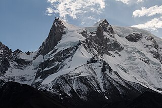
Muztagh Tower, also Mustagh Tower; Muztagh: icy mountain), is a mountain situated in Baltoro Muztagh, which is a segment of the Karakoram range. It straddles the border of the Gilgit–Baltistan region of Pakistan and the Xinjiang Uyghur Autonomous Region of China. Muztagh Tower is located between the basins of the Baltoro and Sarpo Laggo glaciers.

Kamet is the second-highest mountain in the Garhwal region of Uttarakhand, India, after Nanda Devi. It is the 29th highest mountain in the world. It lies in the Chamoli District of Uttarakhand. Its appearance resembles a giant pyramid topped by a flat summit area with two peaks.

The Dent Blanche is a mountain in the Pennine Alps, lying in the canton of Valais in Switzerland. At 4,357 m (14,295 ft)-high, it is one of the highest peaks in the Alps.

The Aiguille de Bionnassay is a mountain in the Mont Blanc massif of the Alps in France and Italy. It has been described as "one of the most attractive satellite peaks of Mont Blanc", and is located on its western side. The mountain's south and east ridges form the frontier between the two countries, and its summit is a knife-edge crest of snow and ice. Reaching it via any route provides a "splendid and serious snow and ice climb".

The Trango Towers are a family of rock towers situated in the Gilgit-Baltistan region, in the northern part of Pakistan. The Towers have some of the world's largest cliffs and offer some of the most challenging big wall climbing opportunities. Each year, climbers from around the world embark on expeditions to the Karakoram region to climb these granite faces. The Trango Towers are situated to the north of the Baltoro Glacier and are part of the Baltoro Muztagh, which is a sub-range within the Karakoram mountain range. The highest point within the group is the summit of Great Trango Tower at 6,286 m (20,623 ft), the east face of which features the world's greatest nearly vertical drop.

Baintha Brakk or The Ogre is a steep, craggy mountain, 7,285 metres (23,901 ft) high, in the Panmah Muztagh, a subrange of the Karakoram mountain range. It is located in Gilgit-Baltistan, Pakistan. It is famous for being one of the hardest peaks in the world to climb: twenty-four years elapsed between the first ascent in 1977 and the second in 2001.

The Dom is a mountain of the Pennine Alps, located between Randa and Saas-Fee in the canton of Valais in Switzerland. With a height of 4,546 m (14,915 ft), it is the seventh highest summit in the Alps, overall. Based on prominence, it can be regarded as the third highest mountain in the Alps, and the second highest in Switzerland, after Monte Rosa. The Dom is the main summit of the Mischabel group, which is the highest massif lying entirely in Switzerland.

The Barre des Écrins is a mountain in the French Alps with a peak elevation of 4,102 metres (13,458 ft). It is the highest peak of the Massif des Écrins and the Dauphiné Alps and the most southerly alpine peak in Europe that is higher than 4,000 metres. It is the only 4,000-metre mountain in France that lies outside the Mont Blanc Massif. Before the annexation of Savoy in 1860 it was the highest mountain in France.

The Kangshung Face or East Face is the eastern-facing side of Mount Everest, one of the Tibetan sides of the mountain. It is 3,350 metres (11,000 ft) from its base on the Kangshung Glacier to the summit. It is a broad face, topped on the right by the upper Northeast Ridge, and on the left by the Southeast Ridge and the South Col. Most of the upper part of the face is composed of hanging glaciers, while the lower part consists of steep rock buttresses with couloirs between them. The steep southern third of the Kangshung Face also comprises the Northeastern Face of Lhotse; this section may be considered a separate face altogether following the division of the South "Neverest" Buttress up to the South Col. It is considered a dangerous route of ascent, compared to the standard North Col and South Col routes, and it is the most remote face of the mountain, with a longer approach.

Bugaboo Spire is a peak in Bugaboo mountain range in Canada, located between the Vowell and Crescent glaciers, just under 2 km West of the ACC's Conrad Kain hut. It is known for its alpine climbing. The Spire was first climbed by Conrad Kain in 1916.

The Ober Gabelhorn is a mountain in the Pennine Alps in Switzerland, located between Zermatt and Zinal.

The Täschhorn is a mountain in the Pennine range of the Alps in Switzerland. There are no easy mountaineering routes to its summit, and it is regarded as being among the top ten 4,000-metre mountains in the Alps for difficulty, and "one of the highest, finest and least accessible 4000m mountains". It lies immediately north of the Alphubel, and south of the Dom within the Mischabel range, and is very similar in shape to the Dom when seen from the upper Zermatt valley.

Nilkantha is a major peak of the Garhwal division of the Himalayas, in the Uttarakhand region of the Indian state of Uttarakhand. Although substantially lower than the highest peaks of the region, it towers dramatically over the valley of the Alaknanda River and rises 3,474 metres (11,398 ft) above the Hindu pilgrimage site of Badrinath, only 9 km (6 mi) to the east. Frank Smythe described the peak as "second only to Siniolchu in Himalayan beauty."
Abi Gamin is a Himalayan mountain peak mostly situated in the Chamoli district of Uttarakhand state in India, 2 km (1.2 mi) northeast of Kamet. Its summit is on the border with Tibet and its northern slope is in the Ngari Prefecture of Tibet.

Balakun is a Himalayan peak situated in the Chamoli district of Uttarakhand state of India. The Balakun peak has the summit at an altitude of 6,471 m (21,230 ft) in the Garhwal Himalayas. Balakun Peak is located 16 km from Badrinath. Balakun is situated north west to Badrinath. Balakun is situated between Bhagirathi Kharak glacier and Satopanth glacier. The peak is situated north east of Nilkanth peak. The Alaknanda river originates from below this peak by the melting of these two glaciers at an altitude of 3,641 m (11,946 ft). The two glaciers rise from the eastern slopes of Chaukhamba (7140 m) peak and wrap around the Balakun peak. Balakun is situated north of Kunaling (5471 m) and south of the Arwa Group. The peak was first climbed in 1973 a by six-man team of ITBP led by Hukum Singh.
Swargarohini is a mountain massif in the Saraswati (Bandarpunch) Range of the Garhwal Himalaya. It lies in the Uttarkashi District of the northern Indian state of Uttarakhand, west of the Gangotri group of peaks. It comprises four separate peaks, the main peak Swargarohini I is the subject of this article.

The Weisshorn is a major peak of Switzerland and the Alps, culminating at 4,505 metres above sea level. It is part of the Pennine Alps and is located between the valleys of Anniviers and Zermatt in the canton of Valais. In the latter valley, the Weisshorn is one of the many 4000ers surrounding Zermatt, with Monte Rosa and the Matterhorn.

Eldorado Peak is a 8,868-foot (2,703 m) peak, and is the 25th highest peak in Washington. The mountain is located in the North Cascades of Washington, approximately 27 miles (43 km) east of Concrete. It is located in North Cascades National Park at the head of Marble Creek and just west of the Inspiration Glacier. Other glaciers in the immediate vicinity include Eldorado Glacier and McAllister Glacier; thus Eldorado is flanked by the largest continuous non-volcanic ice sheet in the lower 48 states.
Janhukut is a mountain of Garhwal Himalaya in Uttarakhand India. Janhukut standing majestically at 6805 meter. It's the 31st highest located entirely within the uttrakhand India. Nanda Devi, is the highest mountain in this category. Janhukut is the 473rd highest peak in the world.


