Chaukhamba

Last updated

Chaukhamba I
Mt. Chaukhamba.jpg
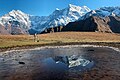
Chaukhamba peak as seen from Deoria Tal/Lake in Chandrashila peak
Highest point
Elevation 7,138 m (23,419 ft) [1]
Prominence 1,594 m (5,230 ft) [2]
Listing Ultra
Coordinates 30°44′59″N79°17′28″E / 30.74972°N 79.29111°E / 30.74972; 79.29111 Coordinates: 30°44′59″N79°17′28″E / 30.74972°N 79.29111°E / 30.74972; 79.29111 [3]
Geography
India relief location map.jpg
Red triangle with thick white border.svg
Chaukhamba
India
Location Uttarakhand, India
Parent range Gangotri Group, Garhwal Himalaya
Climbing
First ascent 13 June 1952, by Lucien George and Victor Russenberger [3] [4]

Chaukhamba is a mountain massif in the Gangotri Group of the Garhwal Himalaya. Its main summit, Chaukhamba I, is the highest peak in the group. It lies at the head of the Gangotri Glacier and forms the eastern anchor of the group. [5] It is located in the northern Indian state of Uttarakhand, west of the Hindu holy town of Badrinath.

Contents

Chaukhamba has four summits, along a northeast–southwest trending ridge, and ranging in elevation from 7,138 metres (23,419 ft) to 6,854 m (22,487 ft) with an average elevation 7,014 m; [3] the main summit is at the northeast end.

Chaukamba I7,138 m (23,419 ft)
Chaukamba II7,070 m (23,196 ft)
Chaukamba III6,995 m (22,949 ft)
Chaukamba IV6,854 m (22,487 ft)

After unsuccessful attempts in 1938 and 1939, Chaukhamba I was first climbed on 13 June 1952, by Lucien George and Victor Russenberger (Swiss members of an otherwise French expedition). They ascended the northeast face, from the Bhagirathi-Kharak Glacier. [4] The other members of the expedition were the French alpinist and traveler Marie-Louise Plovier Chapelle and the renown French alpinist and climber Edouard Frendo.

Chaukhamba I is an ultra-prominent peak, with a prominence of more than 1,500m. Mana Pass is the key col for Chaukhamba I.

Mt Mandani and Chaukhamba with reflection on semi frozen lake at Boodha Madhyamaheshwar Mt Mandani and Chaukhamba with reflection at Boodha Madhyamaheshwar 3500m Photo by Sumita Roy.jpg
Mt Mandani and Chaukhamba with reflection on semi frozen lake at Boodha Madhyamaheshwar
Chaukhamba Massif from Bedni Bugyal Chaukhamba from Bedni Bugyal.jpg
Chaukhamba Massif from Bedni Bugyal
Chaukhamba View From Kartik Swami Temple Rudraprayag Chaukhamba View From Kartik Swami Temple Rudraprayag (cropped).jpg
Chaukhamba View From Kartik Swami Temple Rudraprayag

See also

Related Research Articles

Kamet Mountain in Uttarakhand, India

Kamet is the second highest mountain in the Garhwal region of Uttarakhand, India, after Nanda Devi. It lies in the Chamoli District of Uttarakhand. Its appearance resembles a giant pyramid topped by a flat summit area with two peaks.

Gangotri Group

The Gangotri Group of mountains is a subdivision of the Garhwal Himalaya in the northern Indian state of Uttarakhand. It rings the Gangotri Glacier, and contains peaks that are notable either for their religious significance to Hindus, for their difficult climbing routes, or both. Climbs on three of the peaks have resulted in the awarding of the prestigious climbing award, the Piolet d'Or.

Trisul Mountain in Uttarakhand, india

Trisul is a group of three Himalayan mountain peaks of western Kumaun, Uttarakhand, with the highest reaching 7120m. The three peaks resemble a trident - in Hindi/Sanskrit, Trishula, trident, is the weapon of Shiva. The Trishul group forms the southwest corner of the ring of peaks enclosing the Nanda Devi Sanctuary, about 15 kilometres (9 mi) west-southwest of Nanda Devi itself. The main peak, Trisul I, was the first peak over 7,000 m (22,970 ft) to have ever been climbed, in 1907.

Swargarohini Mountain massif in Uttarakhand, India

Swargarohini is a mountain massif in the Saraswati (Bandarpunch) Range of the Garhwal Himalaya. It lies in the Uttarkashi District of the northern Indian state of Uttarakhand, west of the Gangotri group of peaks. It comprises four separate peaks, the main peak Swargarohini I is the subject of this article.

Shivling (mountain)

Shivling is a mountain at tapovan in the Gangotri Group of peaks in the western Garhwal Himalaya, near the snout of the Gangotri Glacier, one of the biggest glaciers in the Himalayas, and Tapovan, a beautiful lush meadows, both being also popular pilgrimage sites in Hinduism. It lies in the northern Indian state of Uttarakhand, 6 kilometres (4 mi) south of the Hindu holy site of Gaumukh. Its name refers to its status as a sacred symbol -Shiva Linga. It was called "Matterhorn Peak" by early European visitors because of its similarity in appearance to that Alpine peak. While not of locally great elevation, it is a dramatic rock peak, and the most visually striking peak as seen from Gaumukh; that and the difficulty of the climb make it a famed prize for mountaineers.

Thalay Sagar

Thalay Sagar is a mountain in the Gangotri Group of peaks in the western Garhwal Himalayas, on the main ridge that lies south of the Gangotri Glacier. It lies in the northern Indian state of Uttarakhand, 10 kilometres (6 mi) southwest of the Hindu holy site of Gaumukh. It is the second highest peak on the south side of the Gangotri Glacier, but it is more notable for being a dramatic rock peak, steep on all sides, and a famed prize for mountaineers. It is adjacent to the Jogen group of peaks, and has the lake Kedartal at its base.

Sri Kailash Mountain in Uttarakhand, India

Sri Kailash is a mountain in Uttarakhand, India, the 47th highest located entirely within India. Nanda Devi, is the highest mountain in this category. Sri Kailash 204th highest peak in the world. The summit is 6932 meter or 22744 feet. It is the fourth highest mountain in the Gangotri region. The three above peaks in this region are Chaukhamba (7134m), Satopanth (7075m), Kedarnath (6940m). It is situated at the head of The Raktvarn Glacier.

Bhagirathi Massif

Bhagirathi Massif or Bhagirathi Group is a mountain range of Garhwal Himalaya in Gangotri Glacier Uttarakhand India, It has four peaks between 6856 meter and 6193 meter. The Bhagirathi I summits is 6856 meter or 22493 feet. It was first climbed by A Japanese team in 1980. It is surrounded by Glaciers on four side on the eastern side of the Massif is Vasuki Glacier, on the western side its Gangotri Glacier the main glacier in this area, northern side is surrounded by Chaturangi Glacier and southern side guarded by Swachhhand Glacier.

Vasuki Parbat

Vasuki Parbat or Vasuki Parvat is a mountain range of Garhwal Himalaya in Vasuki Glacier Uttarakhand, India, It has a subsidiary peak Vasuki south. Vasuki Parbat standing majestically at 6792 meter and the south peak 6702 meter. Its the 35th highest located entirely within the uttrakhand India. Nanda Devi, is the highest mountain in this category.

Janhukut

Janhukut is a mountain of Garhwal Himalaya in Uttarakhand India. Janhukut standing majestically at 6805 meter. It's the 31st highest located entirely within the uttrakhand India. Nanda Devi, is the highest mountain in this category. Janhukut is the 473rd highest peak in the world.

Kalanka Mountain in Garhwal Himalaya

Kalanka is a mountain of Garhwal Himalaya in Uttarakhand, India. Kalanka stands at 6931 meter 22740 feet. It's the 20th highest located entirely within the Uttrakhand. Nanda Devi is the highest mountain in this category. Kalanka is the 48th highest peak in India and 319th highest peak in the world. Southern side of Kalanka is falls under Nanda Devi National Park.

Swachhand is a mountain of the Garhwal Himalayas in Uttarakhand, India. Swachhand is 6,721 metres (22,051 ft) high. Its peak is the 46th highest located entirely within the Uttrakhand. Nanda Devi is the highest mountain in this category. Swachhand lies between the Satopanth 7,075 metres (23,212 ft) NNW and Janhukut 6,805 metres (22,326 ft) SSE. It's neighbour Janhukut peaks at 3.8 km SSE. It is located 8.9 km NW of Chaukhamba I 7,138 metres (23,419 ft) and 8.9 km NW lies Bhagirathi I 6,856 metres (22,493 ft).

Chaturbhuj is a mountain of the Garhwal Himalaya in Uttarakhand, India. The elevation of Chaturbhuj is 6,654 metres (21,831 ft) and its prominence is 357 metres (1,171 ft). It is 52nd highest located entirely within the Uttrakhand. Nanda Devi, is the highest mountain in this category. Chaturbhuj lies between the Matri 6,721 metres (22,051 ft) and Shwetvarn 6,340 metres (20,801 ft). Its nearest higher neighbor Yogeshwar lies 2.7 km east. It is located 5.9 km NW of chirbas Parbat 6,529 metres (21,421 ft) and 8.5 km east lies Sri Kailash 6,932 metres (22,743 ft).

Kharchakund Mountain in Uttarakhand, India

Kharchakund is a mountain of the Garhwal Himalaya in Uttarakhand, India. The elevation of Kharchakund is 6,612 metres (21,693 ft) and its prominence is 835 metres (2,740 ft). It is 64th highest located entirely within the Uttrakhand. Nanda Devi, is the highest mountain in this category. It is surrounded by Gangotri Glacier and Ghanoim Bamak. Its nearest higher neighbor Kedarnath Dome 6,831 metres (22,411 ft) lies 6.4 km WNW. It is located 1.2 km NNE of Sumeru Parbat 6,351 metres (20,837 ft) and 10.7 km east lies Janhukut 6,829 metres (22,405 ft).

Kirti Stambh is a mountain of the Garhwal Himalaya in Uttarakhand India.The elevation of Kirti Stambh is 6,270 metres (20,571 ft) and its prominence is 100 metres (328 ft). It is 128th highest located entirely within the Uttrakhand. Nanda Devi, is the highest mountain in this category. It lies between Thalaysagar and Bhartekunta. Its nearest higher neighbor Bhartekunta 6,578 metres (21,581 ft) lies 2.3 km SE. It is located 5.1 km SSE of Thalaysagar 6,904 metres (22,651 ft) and 12.8 km NEE lies Bhagirathi I 6,856 metres (22,493 ft).

Mandani Parbat Mountain in Uttarakhand, India

Mandani Parbat is a mountain of the Garhwal Himalaya in Uttarakhand India.The elevation of Mandani Parbat is 6,193 metres (20,318 ft) and its prominence is 535 metres (1,755 ft). It is joint 140th highest located entirely within the Uttrakhand. Nanda Devi, is the highest mountain in this category. It lies between Chaukhamba IV, 6,854 metres (22,487 ft) and Sumeru Parbat, 6,351 metres (20,837 ft). Its nearest higher neighbor Chaukhamba IV lies 5.5 km east. It is located 8.4 km SE of Sumeru Parbat and 6.5 km NE lies Janhukut 6,829 metres (22,405 ft).

Jogin III is a mountain of the Garhwal Himalaya in Uttarakhand, India. The elevation of Jogin III is 6,116 metres (20,066 ft). It is 155th highest located entirely within the Uttrakhand. Nanda Devi, is the highest mountain in this category.

Balbala is a mountain of the Garhwal Himalaya in Uttarakhand India. It is situated in the Zanskar Range on the border between India and China. The elevation of Balbala is 6,416 metres (21,050 ft) and its prominence is 305 metres (1,001 ft). It is 100th highest located entirely within the Uttrakhand. Nanda Devi, is the highest mountain in this category. It lies 2 km east of Balbala West 6,282 metres (20,610 ft). Saraswati Parbat I 6,940 metres (22,769 ft) lies 6.5 km ENE and it is 9.6 km WNW of Chamrao Parbat I 6,910 metres (22,671 ft). It lies 6.7 km ESE of Tara Parbat 6,069 metres (19,911 ft).

Debabrata Mukherjee (mountaineer) Indian mountain climber

Debabrata Mukherjee is an Indian mountaineer and explorer from West Bengal. He was the oldest, first civilian Indian to climb Mount Everest from the North Col. He is also the first person to cross Chaukhamba Col from Badrinath to reach Gangotri.

References

  1. IMF Archived 11 October 2008 at the Wayback Machine
  2. "High Asia I: The Karakoram, Pakistan Himalaya and India Himalaya (north of Nepal)". Peaklist.org. Retrieved 28 May 2014.
  3. 1 2 3 Himalayan Index
  4. 1 2 American Alpine Journal , 1953, pp. 581–582.
  5. Andy Fanshawe and Stephen Venables, Himalaya Alpine-Style, Hodder and Stoughton, 1995, ISBN   0-340-64931-3, p. 106.