K2, also known as Mount Godwin-Austen or Chhogori, at 8,611 metres (28,251 ft) above sea level, is the second highest mountain in the world, after Mount Everest at 8,848 metres (29,029 ft). It is located on the China–Pakistan border between Baltistan in the Gilgit-Baltistan region of northern Pakistan, and the Taxkorgan Tajik Autonomous County of Xinjiang, China. K2 is the highest point of the Karakoram range and the highest point in both Pakistan and Xinjiang.

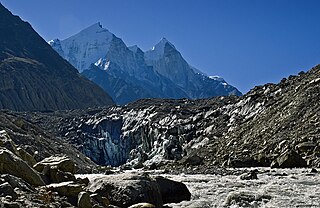
Gangotri Glacier is located in Uttarkashi District, Uttarakhand, India in a region bordering Tibet. Sanskrit and Pahadi are the most languages being spoken here This glacier, one of the primary sources of the Ganges, is one of the largest in the Himalayas with an estimated volume of over 27 cubic kilometers. The glacier is about 30 kilometres long and 2 to 4 km wide. Around the glacier are the peaks of the Gangotri Group, including several peaks notable for extremely challenging climbing routes, such as Shivling, Thalay Sagar, Menu, and Bhagirathi III. It flows roughly northwest, originating in a cirque below Chaukhamba, the highest peak of the group.

Kamet is the second highest mountain in the Garhwal region of Uttarakhand, India, after Nanda Devi. It lies in the Chamoli District of Uttarakhand. Its appearance resembles a giant pyramid topped by a flat summit area with two peaks.

The Trango Towers are a family of rock towers situated in Gilgit-Baltistan, in the north of Pakistan. The Towers offer some of the largest cliffs and most challenging rock climbing in the world, and every year a number of expeditions from all corners of the globe visit Karakoram to climb the difficult granite. They are located north of Baltoro Glacier, and are part of the Baltoro Muztagh, a sub-range of the Karakoram range. The highest point in the group is the summit of Great Trango Tower at 6,286 m (20,623 ft), the east face of which features the world's greatest nearly vertical drop.

Baintha Brakk or The Ogre is a steep, craggy mountain, 7,285 metres (23,901 ft) high, in the Panmah Muztagh, a subrange of the Karakoram mountain range. It is located in Gilgit-Baltistan, Pakistan. It is famous for being one of the hardest peaks in the world to climb: twenty-four years elapsed between the first ascent in 1977 and the second in 2001.

Shispare is one of the high peaks of the Batura Muztagh, which is the westernmost subrange of the Karakoram range.

Kumbhakarna or Jannu is the 32nd highest mountain in the world. It is an important western outlier of Kangchenjunga, the world's third highest peak. Kumbhakarna is a large and steep peak in its own right, and has numerous challenging climbing routes.

The Latok group is a small cluster of dramatic rock peaks in the Panmah Muztagh, part of the central Karakoram mountain range in Pakistan. They lie just to the east of the Ogre group, dominated by Baintha Brakk. To the immediate south of the Latok group lies the Baintha Lukpar Glacier, a small tributary of the Biafo Glacier, one of the main glaciers of the Karakoram. On the north side of the group lies the Choktoi Glacier.

Nilkantha is a major peak of the Garhwal division of the Himalayas, in the Uttarakhand region of the Indian state of Uttarakhand. Although substantially lower than the highest peaks of the region, it towers dramatically over the valley of the Alaknanda River and rises 3,474 metres (11,398 ft) above the Hindu pilgrimage site of Badrinath, only 9 km (6 mi) to the east. Frank Smythe described the peak as "second only to Siniolchu in Himalayan beauty."

Balakun is a Himalayan peak situated in the Chamoli district of Uttarakhand state of India. The Balakun peak has the summit at an altitude of 6,471 m (21,230 ft) in the Garhwal Himalayas. Balakun Peak is located 16 km from Badrinath. Balakun is situated north west to Badrinath. Balakun is situated between Bhagirathi Kharak glacier and Satopanth glacier.The peak is situated north east of Nilkanth peak. The Alaknanda river originates from below this peak by the melting of these two glaciers at an altitude of 3,641 m (11,946 ft). The two glaciers rise from the eastern slopes of Chaukhamba (7140 m) peak and wrap around the Balakun peak. Balakun is situated north of Kunaling (5471 m) and south of the Arwa Group. The peak was first climbed in 1973 a by six-man team of ITBP led by Hukum Singh.

Swargarohini is a mountain massif in the Saraswati (Bandarpunch) Range of the Garhwal Himalaya. It lies in the Uttarkashi District of the northern Indian state of Uttarakhand, west of the Gangotri group of peaks. It comprises four separate peaks: Swargarohini I is the main peak, and is the subject of this article. While not particularly high by Himalayan standards, and not the highest in the Bandarpunch range, Swargarohini I is notable for its dramatic local relief. For example, its north face drops 2,000 metres (6,560 ft) in less than 2 kilometres (1.2 mi) of horizontal distance, and its south face achieves the same drop in less than 3 kilometres (1.9 mi). This makes it a steep and challenging climb. Swargarohini I has two summits, east and west. The east summit is given an elevation of 6,247 m (20,495 ft), slightly lower than the west summit. However the first ascensionists of the west summit claim that that summit is the higher of the two.

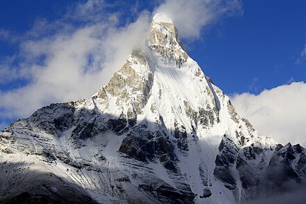
Shivling is a mountain at tapovan in the Gangotri Group of peaks in the western Garhwal Himalaya, near the snout of the Gangotri Glacier. It lies in the northern Indian state of Uttarakhand, 6 kilometres (4 mi) south of the Hindu holy site of Gaumukh. Its name refers to its status as a sacred symbol -Shiva Linga. It was called "Matterhorn Peak" by early European visitors because of its similarity in appearance to that Alpine peak. While not of locally great elevation, it is a dramatic rock peak, and most visually striking peak seen from Gaumukh; that and the difficulty of the climb make it a famed prize for mountaineers.

Kedarnath and Kedarnath Dome are two mountains in the Gangotri Group of peaks in the western Garhwal Himalaya in Uttarakhand state, India. Kedarnath (Main) lies on the main ridge that lies south of the Gangotri Glacier, and Kedarnath Dome, a subpeak of the main peak, lies on a spur projecting towards the glacier, two kilometres northwest of Kedarnath. They are at a distance 15 kilometres (9 mi) south of the Hindu holy site of Gaumukh. Kedarnath is the highest peak on the south side of the Gangotri Glacier, and Kedarnath Dome is the third highest. Both peaks have relatively easy routes on their northwest sides, but the east face of Kedarnath Dome is a large, very difficult rock climb.

Kedartal is a glacial lake situated at an altitude of 4,750 metres (15,580 ft) in the Garhwal region of the Himalayas in India. The lake is fed by the snowfall over Thalay Sagar, Meru, Bhrigupanth and other surrounding peaks, and is the source of Kedar Ganga, which in Hindu mythology is considered to be Shiva's contribution to Bhagirathi.

Meru Peak is a mountain that lies in the Garhwal Himalayas, in the state of Uttarakhand in India. It lies between Thalay Sagar and Shivling, and has some highly challenging routes. The name "Meru" likely originated from Primitive Tamil word for spine, referencing the shape of the mountain. It is 6,660 metres (21,850 ft) high. It was the site of the world's highest BASE Jump from 'Earth', by Glenn Singleman and Heather Swan from a height of 6,604 metres (21,667 ft) in June 2006 but has since been surpassed by Valery Rozov's 2013 jump from Everest's North Face.

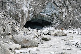
Gomukh, also known as "Gaumukh" or "Gomukhi", is the terminus or pout of the Gangotri Glacier and the source of the Bhagirathi River, one of the primary headstreams of the Ganges River. The place is situated at a height of 13,200 ft in Uttarkashi district in the state of Uttarakhand, India. It is one of the largest in the Himalayas with an estimated volume of over 27 cubic kilometers. It is a popular Hindu pilgrimage site, along with Gangotri, as well as trekking destination. On 26 July 2016, following heavy rains in Uttarakhand, it was reported that the front end of Gomukh was no more, as a large chunk of the glacier had collapsed and was washed away. In 2013, due to cloud burst in Uttarakhand, huge cracks had emerged on the glacier.

Kolahoi Peak is a mountain with a peak elevation of 17,799 ft, in Anantnag district of Jammu and Kashmir, in the vicinity of Sonamarg. Kolahoi Peak is part of the Himalaya Range, and is located between 15 km south of Sonamarg and 21 km north from Aru, Pahalgam. To its north flows the Sind River and the glacier of its name Kolahoi Glacier is the source of Lidder River. in the vicinity of Kashmir valley.
Auden's Col is a high altitude mountain pass connecting Rudugaira valley and Bhilangna valley. It is situated at 5,490 metres (18,010 ft) elevation and connects the ridge coming from Gangotri III peak on the north-west and the ridge coming from Jogin I on the east, and also binds a glacier coming from Jogin I on the north side of Rudugaira valley, and deadly Khatling glacier on the south side of Bhilangna valley.


