
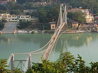
Lakshman Jhula is a suspension bridge across the river Ganges. This is a very famous and older bridge on river ganga and has been closed from 2020. Lakshman Jhula was built in the time of the East India Company.
Lakshman Jhula is a suspension bridge across the river Ganges. This is a very famous and older bridge on river ganga and has been closed from 2020. Lakshman Jhula was built in the time of the East India Company.
It is located 5 kilometres (3 mi) north-east of the city of Rishikesh in the Indian state of Uttarakhand. The bridge connects the villages of Tapovan to Jonk. Tapovan is in Tehri Garhwal district, on the west bank of the river, while Jonk is in Pauri Garhwal district, on the east bank. Lakshman Jhula used to be a pedestrian bridge also used by motorbikes. It is located on the outskirts of the city. It is a landmark of Rishikesh. A larger bridge 2 kilometres (1.2 mi) downstream from Lakshman Jhula is Ram Jhula.
As of November 5, 2020, this bridge is restricted to pedestrian access and is set to be closed permanently when a replacement is built parallel to it. Barriers on both sides prevent vehicular traffic including motorcycles and scooters.
It is said that the Hindu deity Lakshmana crossed the Ganges on jute ropes where the bridge is found. [1] Lakshman Jhula was completed in 1929. [2]
Two plaques exist at the foot of the west side of the bridge.
The first plaque reads:
Lakshman Jhula Bridge
First Jeepable Suspension Bridge of U.P.
Span - 450 feet
Carriage Way - 6 feet
This bridge was constructed by U.P.P.W.D. during 1927-1929. It replaces the old bridge of 284 feet span which was washed away by great floods of October, 1924. This was opened to traffic on 11 April 1930.
Officers / Officials responsible include:
1. Chief Engineer - P. H. Tillard
2. Superintending Engineer - E. H. Cornelius
3. Executive Engineer - C. F. Hunter
4. Assistant Engineers - Jagdish Prasad, Avadh Narain
5. Overseer - Bala Ram
The second plaque reads:
Lakshman Jhuala Suspension Bridge
Span - 450 feet
Height of roadway above mean summer water level - 59 feet
Opened to traffic by H.E. Sir Malcolm Haley C.C.I.E. K.C.S.I. Governor of the United Provinces on 11 April 1930. This bridge was constructed by the Public Works Department during the years 1927-1929. It replaces the old bridge of 284 feet span, which was the gift of Rai Bahadur Surajmal Jhunjhunwala father of Rai Bahadur Shewpershad Tulshan, and was situated about 200 feet down stream. This was washed away by the great flood of October, 1924 which undermined the left abutment. The extra cost of rebuilding this new bridge as nearly as possible on the site of the old bridge has been contributed by Rai Bahadur Shewpershad Tulshan to perpetuate the honored memory of his father and no toll or tax will ever be imposed or realized for crossing this bridge.


A suspension bridge is a type of bridge in which the deck is hung below suspension cables on vertical suspenders. The first modern examples of this type of bridge were built in the early 1800s. Simple suspension bridges, which lack vertical suspenders, have a long history in many mountainous parts of the world.

The Goodwill Bridge is a pedestrian and cyclist bridge which spans the Brisbane River in Brisbane, Queensland, Australia. The bridge connects the South Bank Parklands in South Brisbane to Gardens Point in the Brisbane CBD.

The George Washington Bridge is a double-decked suspension bridge spanning the Hudson River, connecting Fort Lee in Bergen County, New Jersey, with the Washington Heights neighborhood of Manhattan, New York City. It is named after George Washington, a United States founding father and the country's first president. The George Washington Bridge is the world's busiest motor vehicle bridge, carrying a traffic volume of over 104 million vehicles in 2019, and is the world's only suspension bridge with 14 vehicular lanes.

The John A. Roebling Suspension Bridge is a suspension bridge that spans the Ohio River between Cincinnati, Ohio, and Covington, Kentucky. When opened on December 1, 1866, it was the longest suspension bridge in the world at 1,057 feet (322 m) main span, which was later overtaken by John A. Roebling's most famous design of the 1883 Brooklyn Bridge at 1,595.5 feet (486.3 m). Pedestrians use the bridge to get between the hotels, bars, restaurants, and parking lots in Northern Kentucky. The bar and restaurant district at the foot of the bridge on the Kentucky side is known as Roebling Point.
New Tehri is a city and a municipal board in Tehri Garhwal District in the Indian state of Uttarakhand. It is the administrative headquarters of Tehri Garhwal District. This urban municipality area has 11 wards, from Vidhi Vihar to Vishwakarma Puram.

The Howrah Bridge is a balanced steel bridge over the Hooghly River in West Bengal, India. Commissioned in 1943, the bridge was originally named the New Howrah Bridge, because it replaced a pontoon bridge at the same location linking the twin cities of Howrah and Kolkata, which are located at the opposite banks of each other. On 14 June 1965, it was renamed Rabindra Setu after the Bengali poet Rabindranath Tagore, who was the first Indian and Asian Nobel laureate. It is still popularly known as the Howrah Bridge.

Vivekananda Setu is a bridge over the Hooghly River in West Bengal, India. It links the city of Howrah, at Bally, to Kolkata, at Dakshineswar. Completed in 1931, it is a multispan truss bridge that was built to primarily to provide direct road and rail connectivity between the Calcutta Port and the major railhead at Howrah railway station on the West bank of the Hooghly River. It is 880 metres (2,887 ft) long having 9 spans in total. The famous Dakshineswar Kali Temple is situated on the banks of the Hooghly River near the bridge. The bridge is one of the four bridges linking Howrah and Kolkata. A new road bridge, the Nivedita Setu, was constructed 50 m (160 ft) downstream in 2007 due to weakening of the Vivekanada Setu caused by its ageing.

Rishikesh, also spelt as Hrishikesh, is a city near Dehradun in the Indian state Uttarakhand. The northern part of Rishikesh is in the Dehradun district while the southern part is in the Tehri Garhwal district. It is situated on the right bank of the Ganges River and is a pilgrimage town for Hindus, with ancient sages and saints meditating there in search of higher knowledge. There are numerous temples and ashrams built along the banks of the river.

Muni Ki Reti is a town and a municipal council in Tehri Garhwal district in the Indian state of Uttarakhand. It lies close to the pilgrimage town of Rishikesh and is known for its ashrams, including the Divine Life Society of Sivananda Saraswati.

Rudraprayag is a city and a municipality in Rudraprayag district in the Indian state of Uttarakhand. Rudraprayag is one of the Panch Prayag of Alaknanda River, the point of confluence of rivers Alaknanda and Mandakini. Kedarnath, a Hindu holy city, is located 86 km from Rudraprayag. The man-eating leopard of Rudraprayag hunted and written about by Jim Corbett lived here.

Srinagar is a city and municipal corporation in Pauri Garhwal district in the Indian state of Uttarakhand. It is located about 33 km from Pauri town, the administrative headquarters of Pauri Garhwal district, Uttarakhand, India.
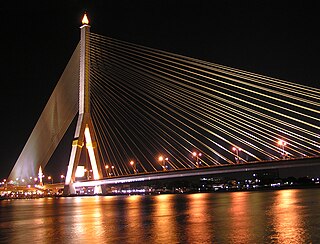
The Rama VIII Bridge is a cable-stayed bridge crossing the Chao Phraya River in Bangkok, Thailand. It was built to alleviate traffic congestion on the nearby Phra Pinklao Bridge. Construction of the bridge took place from 1999 to 2002. The bridge was opened on 7 May 2002 and inaugurated on 20 September, the birth anniversary of the late King Ananda Mahidol, after whom it is named. The bridge has an asymmetrical design, with a single pylon in an inverted Y shape on the west bank of the river. Its eighty-four cables are arranged in pairs on the side of the main span and in a single row on the other. The bridge has a main span of 300 metres (980 ft), and was one of the world's largest asymmetrical cable-stayed bridges at the time of its completion.

Old Blenheim Bridge was a wooden covered bridge that spanned Schoharie Creek in North Blenheim, New York, United States. With an open span of 210 feet (64 m), it had the second longest span of any surviving single-span covered bridge in the world. The 1862 Bridgeport Covered Bridge in Nevada County, California, currently undergoing repairs due to 1986 flooding is longer overall at 233 feet (71 m) but is argued to have a 208 feet (63 m) clear span. The bridge, opened in 1855, was also one of the oldest of its type in the United States. It was destroyed by flooding resulting from Tropical Storm Irene in 2011. Rebuilding of the bridge commenced in 2017 and was completed in 2018.

The Bellows Falls Arch Bridge was a three-hinged steel through arch bridge over the Connecticut River between Bellows Falls, Vermont and North Walpole, New Hampshire. It was structurally significant as the longest arch bridge in the United States when it was completed in 1905.
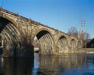
The Philadelphia and Reading Railroad, Schuylkill River Viaduct, also called the Reading Railroad Bridge and the Falls Rail Bridge, is a stone arch bridge that carries rail traffic over the Schuylkill River at Falls of Schuylkill in Philadelphia, Pennsylvania. Located in Fairmount Park, the bridge also spans Martin Luther King, Jr., Drive, and Kelly Drive. The name Philadelphia & Reading Railroad (P&R) was later shortened to Reading Company.

The 11th Street Bridge was completed in December 1915 to carry vehicles across the Arkansas River at Tulsa, Oklahoma. Used from 1916 to 1972, it was also a part of U.S. Route 66. Functionally, it has been replaced by the I-244 bridges across the Arkansas. As of 2009, the bridge was in poor structural condition and unsafe even for pedestrians. In 2008, the gates were locked to exclude all visitors.
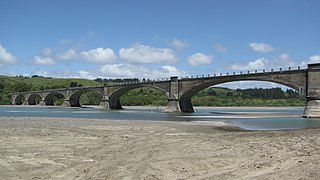
Fernbridge, originally Eel River Bridge, is a 1,320-foot-long (402.3 m) concrete arch bridge designed by American engineer John B. Leonard which opened on November 8, 1911 at the site of an earlier ferry crossing of the Eel River. Fernbridge is the last crossing before the Eel arrives at the Pacific Ocean, and anchors one end of California State Route 211 leading to Ferndale, California. When built, it was referred to as the "Queen of Bridges" and is still the longest functional poured concrete bridge in operation in the world.
Ram Jhula is an iron suspension bridge across the river Ganges, located 3 kilometres (1.9 mi) north-east from the center of the city of Rishikesh in the Indian state of Uttarakhand. The bridge connects the Sivananda Nagar area of Muni Ki Reti in the Tehri Garhwal district to the Swargashram area of Rishikesh in the Pauri Garhwal district, crossing the river from west to east. Built in the year 1986, the bridge is one of the iconic landmarks of Rishikesh.

Ferry Bridge is a Victorian pedestrian bridge over the River Trent in Staffordshire, England. The bridge and its extension, the Stapenhill Viaduct, link Burton upon Trent town centre to the suburb of Stapenhill half a mile away on the other side of the river.
Beatles Ashram, also known as Chaurasi Kutia, is an ashram close to the north Indian city of Rishikesh in the state of Uttarakhand. It is located on the eastern bank of the Ganges river, opposite the Muni Ki Reti area of Rishikesh, in the foothills of the Himalayas. During the 1960s and 1970s, as the International Academy of Meditation, it was the training centre for students of Maharishi Mahesh Yogi, who devised the Transcendental Meditation technique. The ashram gained international attention between February and April 1968 when the English rock band the Beatles studied meditation there, along with celebrities such as Donovan, Mia Farrow and Mike Love. It was the setting for the band's most productive period as songwriters, where they composed most of the songs for their self-titled double album, also known as the "White Album".
30°7′34.9″N78°19′47.6″E / 30.126361°N 78.329889°E
| | This article related to a location in the Indian state of Uttarakhand is a stub. You can help Wikipedia by expanding it. |
| | This article about a bridge in India is a stub. You can help Wikipedia by expanding it. |