Related Research Articles
Garhwal is one of the two administrative divisions of the Indian state of Uttarakhand. Lying in the Himalayas, it is bounded on the north by Tibet, on the east by Kumaon, on the south by Uttar Pradesh state, and on the northwest by Himachal Pradesh state. It includes the districts of Chamoli, Dehradun, Haridwar, Pauri Garhwal, Rudraprayag, Tehri Garhwal, and Uttarkashi. The people of Garhwal are known as Garhwali and speak the Garhwali language. The administrative center for Garhwal division is the town of Pauri. The Divisional Commissioner is the administrative head of the Division, and is a senior Indian Administrative Service officer. As the administrative head of the division, the Commissioner is overall incharge of the 7 districts in the Garhwal region of Uttarakhand, and is aided in his duties by an additional commissioner and the district magistrates. Sushil Kumar is the divisional commissioner of the Garhwal Division since December 2021.

Dehradun, also known as Dehra Doon, is the winter capital and the most populous city of the Indian state of Uttarakhand. It is the administrative headquarters of the eponymous district and is governed by the Dehradun Municipal Corporation, with the Uttarakhand Legislative Assembly holding its winter sessions in the city as its winter capital. Part of the Garhwal region, and housing the headquarters of its Divisional Commissioner, Dehradun is one of the "Counter Magnets" of the National Capital Region (NCR) being developed as an alternative centre of growth to help ease the migration and population explosion in the Delhi metropolitan area and to establish a smart city in the Himalayas.
Mussoorie is a hill station and a municipal board, in Dehradun city in the Dehradun district of the Indian state Uttarakhand. It is about 35 kilometres (22 mi) from the state capital of Dehradun and 290 km (180 mi) north of the national capital of New Delhi. The hill station is in the foothills of the Garhwal Himalayan range. The adjoining town of Landour, which includes a military cantonment, is considered part of "greater Mussoorie", as are the townships Barlowganj and Jharipani.

Haldwani is the largest city of Kumaon. It is also the second most populous city in the Indian state of Uttarakhand. Haldwani is said to be the financial capital of Uttarakhand, having the most commercial, economic and industrial activities of the state. Haldwani is located in the Nainital District, and is one of its thirteen Subdivisions. The Haldwani Urban agglomeration has 656,000 people as of 2021, and is the third most populous UA in Uttarakhand, after Dehradun and Haridwar. Being situated in the immediate foothills of Kumaon Himalayas, the Kathgodam neighbourhood of Haldwani is known as the "Gateway to Kumaon".
Gairsain is a town in Chamoli district of the Indian state of Uttarakhand near state's summer capital Bhararisain. A town and Nagar Panchayat, Gairsain is situated at the eastern edge of the vast Dudhatoli mountain range, and is located in Chamoli district almost at the centre of the state, at a distance of approximately 250 kilometres from Dehradun. It is easily accessible from both the Garhwal and the Kumaon divisions, and in a way, acts as the bridge between the two regions. It is being considered as the future Permanent capital of Uttarakhand.

Rishikesh, also spelt as Hrishikesh, is a city near Dehradun in the Indian state Uttarakhand. The northern part of Rishikesh is in the Dehradun district while the southern part is in the Tehri Garhwal district. It is situated on the right bank of the Ganges River and is a pilgrimage town for Hindus, with ancient sages and saints meditating there in search of higher knowledge. There are numerous temples and ashrams built along the banks of the river.

Doiwala is a town and a Nagar Palika in Dehradun district in the state of Uttarakhand, India.

Gauchar is a hill town located in Karnaprayag tehsil subdistrict within Chamoli district of Uttarakhand state in India. Gauchar is situated on the left bank of river Alaknanda and is en route to the celebrated holy destination of Badrinath. Situated at an altitude of 800 metres (2,620 ft) above the sea level, Gauchar is surrounded by seven mountains. The town is well known for its historic trade fair and airstrip. It is also known for its work to curb the loss of lives in the 2013 floods of Uttarakhand. Gauchar is located on one of the largest pieces of flatland in this mountainous region of Uttarakhand.

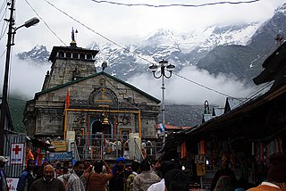
Rudraprayag is a city and a municipality in Rudraprayag district in the Indian state of Uttarakhand. Rudraprayag is one of the Panch Prayag of Alaknanda River, the point of confluence of rivers Alaknanda and Mandakini. Kedarnath, a Hindu holy city, is located 86 km from Rudraprayag. The man-eating leopard of Rudraprayag hunted and written about by Jim Corbett lived here.

The Doon Valley is an unusually wide, long valley within the Sivalik Hills and the Lesser Himalayas, in the Indian states of Uttarakhand, Himachal Pradesh and Haryana. Within the valley lies the city of Dehradun, the winter capital of Uttarakhand state.

The Song River in Dehradun district drains the central and eastern part of the Doon Valley, in the state of Uttarakhand, India. A tributary of Sooswa river, which in turn is a tributary of the Ganges, it originates as spring-fed stream in the southern slopes of the Radi Top of Mussoorie ridge of the Himalayan range and runs from Dhanaulti towards Narendranagar. As is common in hilly areas, there are several streams running south from the mountains that merge into one river that emerges from the hills a little after Sahastradhara.
Uttarakhand is a state in the northern part of India. It is often referred to as the "Devbhoomi" due to its religious significance and numerous Hindu temples and pilgrimage sites found throughout the state. As a result, religious tourism forms a major portion of the tourism in the state. Uttarakhand is known for the natural environment of the Himalayas. 2019 Tourist Arrivals Domestic – 40,000,000 per/year and Foreigner – 150,000 per year. Tourism business in Uttarakhand generated ₹ 23,000 crores during 2013–14.

Sahasradhara, -- popularly but incorrectly spelled Sahastradhara -- meaning thousandfold spring, is one of the most popular tourist destinations located in Dehradun district in Uttarakhand state of India. It lies on 30.387231 latitude and 78.131606 longitude. Earlier, in the 19th century it was also known as Sansadhara, or the petrifying forest. This place is situated on the banks of the small river, Baldi River which a tributary of Song River. The place has once had magnificent beauty of nature where water drips from the limestone stalactites, making the water abundant in sulpur and thus the place is known for its sulphur springs. It is sulphur water spring of relatively lower temperature than its surroundings. It is a warehouse of excellent beauty of caves, waterfalls and terrace farming on steppe by the local people. Its magnificent nature attracts people from faraway places. This place is at about 11 km from the city of Dehradun.

Dehradun Cantonment is one of the seventy electoral Uttarakhand Legislative Assembly constituencies of Uttarakhand state in India. This seat is previously known as Dehradun Constituency before 2002 Delimitation.

Rajiv Gandhi International Cricket Stadium, also colloquially known as Dehradun Cricket Stadium is a cricket stadium in Dehradun, Uttarakhand in India. It is the home ground of Uttarakhand cricket team.

Tapkeshwar Temple, also known as Tapkeshwar Mahadev Temple, is a temple in Dehradun dedicated to Shiva. The temple is on the bank of the Tons River, built on top of a natural cave, which holds the temple's main shivalinga.
Battle of Khurbura or Battle of Khudbuda also known as Gorkha-Garhwal War occurred in May 1804 near modern-day village of Dehradun, Khurbura 30.3256°N 78.0267°E. The battle is regarded as the first major attack in the history of Garhwal Kingdom that triggered between Kingdom of Nepal forces and Maharaja Pradyumna Shah, and continued for 13 days until the Garhwal king was defeated. It is chiefly regarded the only defeat of Pradyumna Shah's life and the victory of Gorkhali forces under Kingdom of Nepal.

Maharaja Pradyumna Shah or Pradyuman Shah, also known as Pradyumna Chand, was the last and 54th ruler of Garhwal dynasty until the kingdom was independent. He reigned over the state territories from 1785 to 14 May 1804, and later the kingdom was defeated by the Gurkha forces after the Battle of Khurbura occurred near Dehradun.
Bindal River flows through Dehradun in Uttarakhand, India, and is fed by a number of springs at the base of Mussoorie ridge.
Dehradun canals refers to the heritage network of canals that was once spread across Dehradun in Uttarakhand, India, with the earliest, Rajpur Canal, dating back to early 17th century. After the city became the state capital in 2000, rapid and unchecked road-widening schemes led to the covering, or in some cases demolition, of most of the historic canals. One of the last remaining canals was covered in 2007.
References
- ↑ Negi, Sharad Singh (24 July 1991). Himalayan Rivers, Lakes, and Glaciers. Indus Publishing. ISBN 9788185182612 – via Google Books.
- ↑ Siddiqui, Nihal Anwar; Tauseef, S. M.; Dobhal, Rajendra (18 February 2020). Advances in Water Pollution Monitoring and Control: Select Proceedings from HSFEA 2018. Springer Nature. ISBN 9789813299566 – via Google Books.
- 1 2 "Rispana: For revival, Rispana river divided into 15 sector | Dehradun News - Times of India". The Times of India. 15 February 2018.
- ↑ "Rawat launches mission to revive Doon's Rispana river". Hindustan Times. 19 May 2018.