Dehradun Cantonment | |
|---|---|
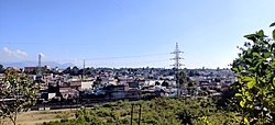
City | |
 | |
 Dehradun Cantonment Location in Uttarakhand, India  Dehradun Cantonment Dehradun Cantonment (India) | |
| Coordinates: 30°20′40″N78°00′00″E / 30.34444°N 78.00000°E | |
| Country | |
| State | Uttarakhand |
| District | Dehradun |
| Elevation | 460 m (1,510 ft) |
| Population (2001) | |
• Total | 30,102 |
| Languages | |
| • Official | Hindi |
| • Native | Khariboli [1] [2] [3] |
| Time zone | UTC+5:30 (IST) |
| PIN | 248003 |
| Telephone code | 0135 |
| Vehicle registration | UK 07 |
| Website | uk |
Dehradun Cantonment is a cantonment town in Dehradun district in the state of Uttarakhand, India. It was established in 1913.