A mountain pass is a navigable route through a mountain range or over a ridge. Since many of the world's mountain ranges have presented formidable barriers to travel, passes have played a key role in trade, war, and both human and animal migration throughout history. At lower elevations it may be called a hill pass. A mountain pass may be formed between two volcanic peaks, or created by erosion from water or wind.

Mandi district is one of the central districts of Himachal Pradesh state in northern India. The town of Mandi is the headquarters of the district. The town has mythological and historical significance and boasts of a unique temple architecture. It is referred to as Chhoti Kashi as there are many ancient temples in the city and on the banks of river Beas.

The Pir Panjal Range is a group of mountains in the Lesser Himalayan region, running from east-southeast (ESE) to west-northwest (WNW) across the Indian territories of Himachal Pradesh and Jammu and Kashmir and then Pakistan's Azad Kashmir. The average elevation varies from 1,400 m (4,600 ft) to 4,100 m (13,500 ft). The Himalayas show a gradual elevation towards the Dhauladhar and Pir Panjal ranges. Pir Panjal is the largest range of the Lesser Himalayas. Near the bank of the Sutlej River, it dissociates itself from the Himalayas and forms a divide between the Beas and Ravi rivers on one side and the Chenab on the other. The renowned Galyat mountains are also located in this range. The region is connected to the Valley of Kashmir via Mughal Road and used to be the historical connection of Kashmir with India.

Banihal is a town and a notified area committee in Ramban district in the Indian union territory of Jammu and Kashmir. It is a rural and hilly area with Kamirwah being one of the most spectacular hills. It is located about 35 km (22 mi) away from Qazigund of Anantnag district on NH 44. However, the distance between Banihal and Qazigund is only 18 km by train on the new railway line which is much shorter than the road. The most common language spoken in the region is Kashmiri; Urdu, Gujjari, English being other familiar languages.

Batote is a town and a notified area committee in Ramban district of Indian union territory of Jammu and Kashmir on NH 44 just beyond Patnitop while going towards Srinagar.

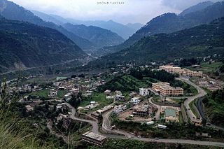
Patnitop or Patni Top is a hilltop tourist location situated in the Ramban district of Jammu and Kashmir, India. It is in located on the Jammu-Srinagar National Highway, 112 km (70 mi) from Jammu, on the way from Udhampur to Srinagar. Situated on a plateau in the Shivalik belt of the Himalayas, Patnitop sits at an altitude of 2,024 m (6,640 ft). The river Chenab flows in close proximity to this location.

Beerwah also pronounced as Beeru is a subdistrict and one of the oldest town of Jammu and Kashmir and a municipal committee in Budgam district in the Indian administered union territory of Jammu and Kashmir. It is also one of the oldest tehsil of Jammu and Kashmir with one of the largest towns in Budgam district. Beerwah tehsil is known as the headquarter tehsil of all the tehsils of Jammu and Kashmir. Beerwah is 27 km (17 mi) away from the summer capital Srinagar via Bemina, 31 km (19 mi) via Magam, 33 km (21 mi) via Soibugh and 35 km (22 mi) via Budgam. Beerwah subdistrict has 4 tehsils namely Beerwah, Magam, Narbal and Khag. Beerwah is located along the banks of River Sukhnaag.
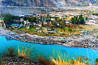
Ramban is a town in Ramban district of Jammu and Kashmir, India, which is the district headquarters of Ramban district. It lies on the banks of the Chenab river in Chenab Valley on the National Highway-1A at about 150 km from Jammu and about 150 km from Srinagar, making it almost the central point on the Jammu-Srinagar National Highway.

Sonamarg or Sonmarg, known as Sonamarag in Kashmiri, is a hill station located in the Ganderbal District of Jammu and Kashmir, India. It is located about 62 Kilometers from Ganderbal Town and 80 kilometres (50 mi) northeast of the capital city, Srinagar.

Jammu and Kashmir is home to several valleys such as the Kashmir Valley, Chenab Valley, Sindh Valley and Lidder Valley. Some major tourist attractions in Jammu and Kashmir are Srinagar, the Mughal Gardens, Gulmarg, Pahalgam, Patnitop and Jammu. Every year, thousands of Hindu pilgrims visit holy shrines of Vaishno Devi and Amarnath which has had significant impact on the state's economy.
Ramban is a district in the Indian union territory of Jammu and Kashmir, located in the lap of the Pir Panjal range. It is one the three districts of Chenab Valley, as it was carved out as a district from erstwhile Doda district in 2007.

Ganderbal district is a district in the Indian administered union territory of Jammu and Kashmir. It was formed in 2007 and has 6 subdistricts (tehsils): Kangan, Ganderbal, Tullamulla, Wakura, Lar, and Gund.
Manasbal Lake is located in Safapora area of Ganderbal District in the union territory of Jammu and Kashmir in India. The name Manasbal is said to be a derivative of the Lake Manasarovar. Lake is encircled by four villages viz., Jarokbal, Kondabal, Nesbal and Gratbal. The large growth of lotus at the periphery of the lake adds to the beauty of the clear waters of the lake. The Mughal garden, called the Jaroka Bagh, built by Nur Jahan overlooks the lake.

Mughal Road is the road between Bufliaz, a town in the Poonch district, to the Shopian district, in the union territory of Jammu and Kashmir, India. The 84-kilometre road traces a historic route used in the Mughal period over the Pir Panjal Pass, at an altitude of 3,500 m (11,500 ft), higher than the Banihal pass at 2,832 m (9,291 ft).

Mountain Paiko or Pajak in Bulgarian is a small mountain range that lies on the border of the Pella and Kilkis regional units in Central Macedonia, Greece.

The Andringitra Massif is a granite massif located within Andringitra National Park in Madagascar. The range is approximately 64 kilometres (40 mi) long. In its central area, the range is almost 10 kilometres (6.2 mi) wide, though it is much narrower on either end. Pic Boby, the highest peak, stands at 2658 meters (8,720 ft) high.

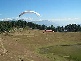
Indrahar (इन्द्रहार) Pass is a mountain pass in the Dhauladhar range of the Himalayas. Located at 32°17.852′N76°22.872′E and an altitude of 4,342 metres (14,245 ft) above mean sea level, near the tourist town of Dharamshala in Himachal Pradesh, Indrahar pass forms the border between Kangra and Chamba districts. It is part of a very popular trekking route from Dharamshala. It attracts substantial tourist traffic during the trekking season between April – October.

The Chenab Valley, also known as the Chenab Region, is the river valley of the Chenab River flowing through the Doda, Kishtwar and Ramban districts of Jammu Division in Jammu and Kashmir, India. This name refers to the erstwhile Doda district.

Kotla is a village and tourist resort in Bagh District, Azad Kashmir, Pakistan. Kotla is 6,560 feet (2,000 m) above sea level. Kotla contains pine trees that are hundreds of years old. It takes approximately 1 hour to drive from Bagh to Kotla.

The Jammu Division is a revenue and administrative division within Jammu and Kashmir, a union territory of India. It consists of the districts of Jammu, Doda, Kathua, Ramban, Reasi, Kishtwar, Poonch, Rajouri, Udhampur and Samba. Most of the land is hilly or mountainous, including the Pir Panjal Range which separates it from the Kashmir Valley and part of the Great Himalayas in the eastern districts of Doda and Kishtwar. Its principal river is the Chenab.