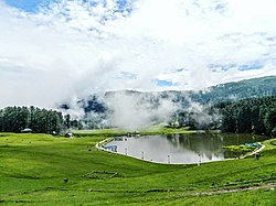
Udhampur (ˌʊd̪ʱəmpur) is a city and a municipal council in Udhampur district in the Indian union territory of Jammu and Kashmir. It is the headquarters of Udhampur District. Named after Raja Udham Singh, it serves as the district capital and the Northern Command headquarters of the Indian Army. A Forward Base Support Unit (FBSU) of the Indian Air Force is also stationed here. Udhampur is used by the Armed Forces as a transit point between Jammu and Srinagar when travelling by road on National Highway 1A, which has since been renamed as National Highway 44.
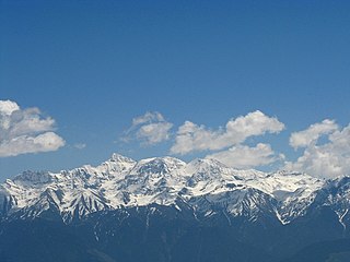
The Pir Panjal Range is a range of mountains in the Lower Himalayan region located in the Western Himalayas of northern Indian subcontinent. It runs southeast to northwest between the Beas and Neelam/Kishanganga rivers, in the Indian state of Himachal Pradesh and Indian-administered union territory of Jammu and Kashmir, with its northwestern end extending into territory administered by Pakistan. The Himalayas show a gradual elevation towards the Dhauladhar and Pir Panjal ranges. Pir Panjal is the largest and westernmost range of the Lesser Himalayas. Near the bank of the Sutlej River, it dissociates itself from the main Himalayan range and forms a divide between the Beas and Ravi rivers on one side and the Chenab on the other. Further west, the Pir Panjal range forms the southwestern boundary of the Kashmir Valley, separating it from the hills of Jammu region, forming a divide between the Jhelum and Chenab rivers.

Udhampur is an administrative district in the Jammu division of Indian-administered Jammu and Kashmir in the disputed Kashmir region. Covering an area of 4,550 square kilometres (1,760 sq mi) in the Himalayan mountains, the district has its headquarters in the town of Udhampur. The Northern Command headquarters of the Indian Army is located in the district.
The Jammu–Baramulla line is a railway track being laid to connect the Kashmir Valley in the Indian union territory of Jammu and Kashmir with Jammu railway station and thence to the rest of the country. The 338 km railway track will start from Jammu and end at Baramulla. It comes under the jurisdiction of the Firozpur railway division of Indian Railways's Northern zone. Part of this railway route from Udhampur to Baramulla is known as Udhampur-Srinagar-Baramula Rail Link (USBRL). The 359 m (1,178 ft) high Chenab Bridge lies on this line, which is the highest railway bridge in the world. The total project cost in 2022 was INR28,000 crore. Construction of the route faced natural challenges including major earthquake zones, extreme temperatures and inhospitable terrain.

Banihal is a town and a notified area committee, near Ramban town in Ramban district in the Indian union territory of Jammu and Kashmir. It is a rural and hilly area with Kamirwah being one of the most prominent hills. It is located about 35 km (22 mi) away from Qazigund of Anantnag district on NH 44. However, the distance between Banihal and Qazigund is only 18 km by train on the new railway line which is much shorter than the road. The most common language spoken in the region is Kashmiri; Urdu, Hindi, Gujjari, Pahari and English are other familiar languages.
Batote is a town and a notified area committee, near Ramban town in Ramban district of Indian union territory of Jammu and Kashmir on NH 44 just beyond Ramban, Patnitop while going towards Srinagar.
Chanani or Chenani is a town and tehsil in the Udhampur district, in the Indian union territory of Jammu and Kashmir. It is governed by a notified area council. Before 1947, it was an internal jagir ruled by a Chandel (Rajput) ruler in the princely state of Jammu and Kashmir. This Town has further gained importance after getting the Asia's longest tunnel from chenani to nasari.
Kud is a town and a notified area committee in Udhampur district in the Indian union territory of Jammu and Kashmir. It is about 10 km from the popular tourist place Patnitop and is famous for a local sweet known as "Desi Ghee Patisa" another name of the sweet made up of milk products. Desi Ghee is a milk product and patisa is known as Papdi.

Jammu and Kashmir is home to several valleys such as the Kashmir Valley, Chenab Valley, Sindh Valley and Lidder Valley. Some major tourist attractions in Jammu and Kashmir are Srinagar, with its renowned Dal Lake and Mughal Gardens, Gulmarg, Pahalgam, Bhaderwah, Patnitop and Jammu. Every year, thousands of Hindu pilgrims visit holy shrines of Vaishno Devi and Amarnath which has had a significant impact on the state's economy.
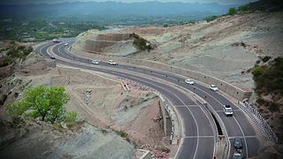
National Highway 44 is a major north–south National Highway in India and is the longest in the country.

Zoji La is a high mountain pass in the Himalayas. It is in the Kargil district, Indian Union territory of Ladakh. Located in the Dras subdivision, the pass connects the Kashmir Valley to its west with the Dras and Suru valleys to its northeast and the Indus valley further east. National Highway #1 between Srinagar and Leh in the western section of the Himalayan mountain range, traverses the pass. As of late 2022, an all-weather Zoji-la Tunnel is under construction to mitigate seasonal road blockages due to heavy snowfall.

The Banihal-Qazigund Railway Tunnel or Pir Panjal railway tunnel is an 11.215 kilometres (6.969 mi) long railway tunnel located in Pir Panjal Range of middle Himalayas in Jammu and Kashmir, India, south of Qazigund town. It is a part of the Jammu–Baramulla line.

The Jammu–Srinagar National Highway is the northernmost segment of NH 44. It runs from Srinagar in the Kashmir Valley southward to the city of Jammu.

The Udhampur Jammu highway is a four lane road in Jammu and Kashmir that connects the municipal committee of Udhampur with Jammu City. The highway is 64 kilometres (40 mi) long, passing through mountain terrain. The highway provides a road link that connects Katra with the rest of India. The highway is a small part of Jammu–Srinagar National Highway.
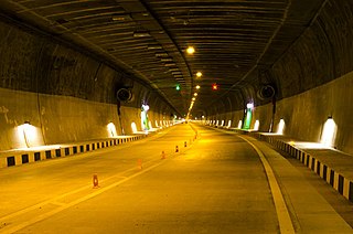
Chenani-Nashri Tunnel, Officially known as Dr. Syama Prasad Mookerjee Tunnel, is a road tunnel in Jammu and Kashmir, India. It is located in the Lower Himalayas, on National Highway 44. Construction started in 2011 and was completed by 2017.

The Z-MorhTunnel is a 6.5 km long 2-lane road tunnel between Gagangair and Sonamarg in Ganderbal district of Union Territory of Jammu and Kashmir in India. It is named after the Z-shaped stretch of road that the tunnel has replaced. The road used before was avalanche-prone and used to get blocked for several months, but the Z-Morh tunnel provides all-weather connectivity to the Sonamarg tourist town. It takes only 15 minutes to travel the 6.5 km long tunnel compared to hours over the zig-zag road up and down the hills.
Zoji La Tunnel is an under-construction 9.5 m wide, 7.57 m high and 14.2 km long, horseshoe-shaped single-tube, 2 lane road tunnel at the height of 11,575 feet above sea level which passes under the Zoji La pass in the Himalayas between Ganderbal of Kashmir (J&K) and Drass town in Kargil district of Ladakh. The project cost for this smart tunnel (SCADA) system, constructed using the New Austrian tunneling method and equipped with CCTV, radio control, uninterrupted power supply, ventilation, etc is INR 8,308 crore as per 2021 estimates. Together with the adjacent Z-Morh Tunnel, this geostrategically important tunnel on the NH1 Srinagar-Leh Highway will provide year around weather-proof connectivity to Ladakh and Baltal, reduce the earlier 1-1.5 hours travel time to just 15 minutes drive, boost the tourism and economy, and enhance the logistics of the Indian Armed Forces. It is one of the 31 road tunnels being constructed at a combined cost of INR1400 billion.
Chanderkot is a village panchayat located in Ramban district in the Indian state of Jammu-Kashmir.
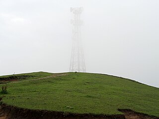
Nathatop is a radar station and tourist spot located, between Sanasar and Patnitop in the Udhampur district of Jammu and Kashmir, India. It is in located on the Jammu-Srinagar National Highway, 121 km (75 mi) from Jammu, on the way from Udhampur to Srinagar. Situated on a plateau in the Shivalik belt of the Himalayas, Nathatop sits at an altitude of 2,133 m (6,998 ft). The river Chenab flows in close proximity to this location. Nathatop lies in District Udhampur of Jammu And Kashmir
