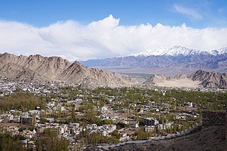
Leh district is a district in the union territory of Ladakh, India. With an area of 45,110 km2, it is the second largest district in the country, second only to Kutch. It is bounded on the north by Gilgit-Baltistan's Kharmang and Ghanche districts and Xinjiang's Kashgar Prefecture and Hotan Prefecture, to which it connects via the historic Karakoram Pass. Aksai Chin and Tibet are to the east, Kargil district to the west, and Lahul and Spiti to the south. The district headquarters is in Leh. It lies between 32 and 36 degree north latitude and 75 to 80 degree east longitude.

Alchi is a village in the Leh district of Ladakh, India. It is located in the Likir tehsil, on the banks of the Indus River 70 km downstream from the capital Leh. Unlike the other gompas in Ladakh, Alchi is situated on lowland, not on a hilltop.

Shey is a village in the Leh district of Ladakh, India. It is located in the Leh tehsil, 15 km from Leh towards Hemis.

Hemis, also spelled Hamis, is a village in the Leh district of Ladakh, India. It is located in the Kharu tehsil, 40 km southeast of Leh town on the Leh-Manali Highway and under-construction Bhanupli–Leh line.

Stok is a village in the Leh district of Ladakh, India. It is located in the Leh tehsil, in the Indus Valley 17 km southeast of the Leh town.

Upshi is a village and road junction on the Leh-Manali Highway in the union territory of Ladakh in India. It is located 47 km (29 mi) to the southeast of Leh along the Indus river valley and Tanglang La on the Leh-Manali highway. Gya is also to the south.

Nimo or Nyemo is a village and the headquarters of an eponymous community development block in the Leh district of Ladakh, India. It is located in the Leh tehsil, 35 km from Leh.
Nyoma is a principal village of southern Ladakh in India, the headquarters of an eponymous subdivision, tehsil, community development block and Indian Air Force Base in the Leh district. It is located on the bank of the Indus river after its 90-degree bend near Dungti east of Nyoma and before the valley narrows to a gorge near Mahe northwest of Nyoma. The Nyoma tehsil and subdivision cover all of southern Ladakh, including the Rupshu plains south of Nyoma, the Indus valley of Skakjung north of Nyoma, and the Hanle valley. Nyoma gompa, a Buddhist monastery, is located on the hill slope north of the village.

Stakna is a village in the Leh district of Ladakh, India. It is located in the Leh tehsil, on the banks of the Indus River. The Stakna Monastery is located here.
Chiling Sumda is a village in the Leh district of Ladakh, India. It is located in the Likir tehsil, on the bank of the Indus river in Ladakh region. It serves as a base camp for the Chadar Trek in the winters and is used to raft the Zanskar river in the summers.
Chuchot Shama is a village in the Leh district of Ladakh, India. It is located in the Leh tehsil. The village is located on the banks of river Indus (sindh).
Dah is a panchayat village in the Leh district of Ladakh, India. It is the most prominent of all the Brokpa settlements, other than Dah, it has five hamlets: Biama, Baldes, Sannit, Pardos, and Lastyang. It is located in lower Indus valley of Ladakh in the Khalsi tehsil.
Domkhar, also spelt Damkhar, is a village in Leh district of Ladakh in India. It is located in the Khalsi tehsil.
Changa is a village in the Leh district of Ladakh, India. It is located in the Kharu tehsil, on the bank of the Indus River.
Hundri is a village in the Leh district of Ladakh, India. It is located in the Nubra tehsil, beside the Shayok River. There is no bridge in village Hundri. Terchey and Udmaru are neighbours of Hundri. Fruits such as apricot, mulberry, apple, strawberry are grown there.

Phyang is a village in Leh district of Ladakh in India. It is in the Leh tehsil. The Phyang Monastery is in this village. This is one of the largest inhabited villages of Ladakh, comprising eight clusters: Phulungs, Phyang, Tsakma, Changmachan, Gaon, Thangnak, Chusgo and Mankhang. It is in a south-facing valley in the Ladakh Range of mountains. The village is about 15 km (9.3 mi) long and 1.5 km (0.93 mi) average width. There is an old dilapidated castle near the cluster of Phyang on a hilltop. Just below this castle, there is a single-room temple, Lobon, with paintings of Ladakh, but in the tourism industry, it is known as Guru Lhakhang. The Tokpo river is in the middle of the valley. The source of the river is small glaciers in upper Spangkul and Lungnak valley northwest of the village at an altitude of about 5,200 m (17,100 ft). The river joins the Indus River near Phey village at a lower altitude of 3,250 m (10,660 ft). The village has some tourist facilities, including a guesthouse and campsites. Hidden North guesthouse is just opposite the site of Guru Lhakhang at Tsakma cluster.

Gya or Gia is a village in the Leh district of Ladakh in India. It is located in the Kharu tehsil, off the Leh–Manali Highway, close to Tso Kar.

Hundar is a village in the Leh district of Ladakh, India, famous for sand dunes and Bactrian camels. It is located in the Nubra tehsil, on the banks of the Shyok River. The Hunder Monastery is located here.
Udmaru is a village in the Leh district of Ladakh, India. It is located in the Nubra tehsil, on the banks of Shyok River.
Koyul is a village in the Leh district of Ladakh, India. It is located in the Nyoma tehsil, on the banks of the Koyul Lungpa river just before it joins the Indus River.

