Ladakh is a region administered by India as a union territory which constitutes a part of the larger Kashmir region and has been the subject of dispute between India, Pakistan, and China since 1947. Ladakh is bordered by the Tibet Autonomous Region to the east, the Indian state of Himachal Pradesh to the south, both the Indian-administered union territory of Jammu and Kashmir and the Pakistan-administered Gilgit-Baltistan to the west, and the southwest corner of Xinjiang across the Karakoram Pass in the far north. It extends from the Siachen Glacier in the Karakoram range to the north to the main Great Himalayas to the south. The eastern end, consisting of the uninhabited Aksai Chin plains, is claimed by the Indian Government as part of Ladakh, and has been under Chinese control since 1962.

Leh is the joint capital and largest city of Ladakh, a union territory of India. Leh, located in the Leh district, was also the historical capital of the Kingdom of Ladakh, the seat of which was in the Leh Palace, the former residence of the royal family of Ladakh, built in the same style and about the same time as the Potala Palace in Tibet. Leh is at an altitude of 3,524 m (11,562 ft), and is connected via National Highway 1 to Srinagar in the southwest and to Manali in the south via the Leh-Manali Highway.

Zanskar, Zahar (locally) or Zangskar, is a tehsil of Kargil district, in the Indian union territory of Ladakh. The administrative centre is Padum. Zanskar, together with the neighboring region of Ladakh, was briefly a part of the kingdom of Guge in Western Tibet. Zanskar lies 250 km south of Kargil town on NH301.

Kargil district is one of the two districts comprising Ladakh, India. It is bounded by the Indian-administered union territory of Jammu and Kashmir in the west, Pakistani-administered Gilgit–Baltistan in the north, Ladakh's Leh district in the east, and the Indian state of Himachal Pradesh in the south. Encompassing three historical regions known as Purig, Himbabs and Zanskar, the district lies to the northwest of the Great Himalayas and encompasses the majority of the Zanskar Range. Its population inhabits the river valleys of the Dras, Suru, Kartse, Wakha, and Zanskar.

The Ladakhi language is a Tibetic language spoken in the Indian union territory of Ladakh. A few numbers of Ladakhi speakers are also found in Baltistan, Pakistan. It is the predominant language in the Buddhist-dominated district of Leh. Though a member of the Tibetic family, Ladakhi is not mutually intelligible with Standard Tibetan.

Ladakh has a long history with evidence of human settlement from as back as 9000 b.c. It has been a crossroad of high Asia for thousands of years and has seen many cultures, empires and technologies born in its neighbours. As a result of these developments Ladakh has imported many traditions and culture from its neighbours and combining them all gave rise to a unique tradition and culture of its own.

The Ladakh Range is a mountain range in central Ladakh in India with its northern tip extending into Baltistan in Pakistan. It lies between the Indus and Shyok river valleys, stretching to 230 miles (370 km). Leh, the capital city of Ladakh, is on the foot of Ladakh Range in the Indus river valley.

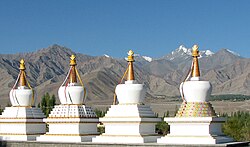
Shey is a village in the Leh district of Ladakh, India. It is located in the Leh tehsil, 15 km from Leh towards Hemis.

Zorawar Singh Kahluria was a military general of the Dogra Rajput ruler, Gulab Singh of Jammu. He served as the governor (wazir-e-wazarat) of Kishtwar and extended the territories of the kingdom by conquering Ladakh and Baltistan. He also boldly attempted the conquest of Western Tibet but was killed in battle of To-yo during the Dogra-Tibetan war. In reference to his legacy of conquests in the Himalaya Mountains including Ladakh, Tibet, Baltistan and Iskardu as General and Wazir, Zorowar Singh has been referred to as the "Napoleon of India", and "Conqueror of Ladakh".

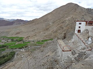
Stok is a village in the Leh district of Ladakh, India. It is located in the Leh tehsil, in the Indus Valley 17 km southeast of the Leh town.
Nyoma is a principal village of southern Ladakh in India, the headquarters of an eponymous subdivision, tehsil and community development block in the Leh district. It is located on the bank of the Indus river, after its 90-degree bend near Dungti and before the valley narrows to a gorge near Mahe. A Buddhist monastery ("gompa") is located on the hill at the back of the village.

Likir Monastery or Likir Gompa (Klud-kyil) is a Buddhist monastery in Ladakh, Northern India. It is located at 3700m elevation, approximately 52 kilometres (32 mi) in the west of Leh. It is picturesquely situated on a little hill in the valley, in Likir village near the Indus River about 9.5 kilometres (5.9 mi) north of the Srinigar to Leh highway. It belongs to the Gelugpa sect of Tibetan Buddhism and was established in 1065 by Lama Duwang Chosje, under the command of the fifth king of Ladakh, Lhachen Gyalpo (Lha-chen-rgyal-po).
The Dogra–Tibetan War or Sino-Sikh War was fought from May 1841 to August 1842, between the forces of the Dogra nobleman Gulab Singh of Jammu, under the suzerainty of the Sikh Empire, and those of Tibet. Gulab Singh's commander was the able general Zorawar Singh Kahluria, who, after the conquest of Ladakh, attempted to extend its boundaries in order to control the trade routes into Ladakh. Zorawar Singh's campaign, suffering from the effects of inclement weather, suffered a defeat at Minsar and Singh was killed. The Tibetans then advanced on Ladakh. Gulab Singh sent reinforcements under the command of his nephew Jawahir Singh. A subsequent battle near Leh in 1842 led to a Tibetan defeat. The Treaty of Chushul was signed in 1842 maintaining the status quo ante bellum.

Murgo is a small hilly village which lies on the border of Leh district in the union territory of Ladakh in India, close to Chinese-controlled Aksai Chin. It is one of the northernmost villages of India.
The Central Institute of Buddhist Studies, formerly known as the School of Buddhist Philosophy, located in Leh town of Ladakh is a deemed university under Ministry of Culture. It was founded in 1959 and formerly affiliated to the Sampurnanand Sanskrit University in Varanasi.
Demchok , previously called New Demchok, and called Parigas by the Chinese, is a village and military encampment in the Indian-administered Demchok sector that is disputed between India and China. It is administered as part of the Nyoma tehsil in the Leh district of Ladakh by India, and claimed by China as part of the Tibet Autonomous Region.
Tangtse or Drangtse (Tibetan: བྲང་རྩེ, Wylie: brang rtse, THL: drang tsé) is a village in the Leh district of Ladakh, India. It is located in the Durbuk tehsil. Traditionally, it was regarded as the border between the Nubra region to the north and the Pangong region to the south. It was a key halting place on the trade route between Turkestan and Tibet. It was also a site of wars between Ladakh and Tibet.

Demchok, was described by a British boundary commission in 1847 as a village lying on the border between the Kingdom of Ladakh and the Tibet. It was a "hamlet of half a dozen huts and tents", divided into two parts by a rivulet which formed the boundary between the two states. The rivulet, a tributary of the Indus River variously called the Demchok River, Charding Nullah, or the Lhari stream, was set as the boundary between Ladakh and Tibet in the 1684 Treaty of Tingmosgang. By 1904–05, the Tibetan side of the hamlet was said to have had 8 to 9 huts of zamindars (landholders), while the Ladakhi side had two. The area of the former Demchok now straddles the Line of Actual Control, the effective border of the People's Republic of China's Tibet Autonomous Region and the Republic of India's Ladakh Union Territory.

The culture of Ladakh refers to the traditional customs, belief systems, and political systems that are followed by Ladakhi people in India. The languages, religions, dance, music, architecture, food, and customs of the Ladakh region are similar to neighboring Tibet. Ladakhi is the traditional language of Ladakh. The popular dances in Ladakh include the khatok chenmo, cham, etc. The people of Ladakh also celebrate several festivals throughout the year, some of the most famous are Hemis Tsechu and Losar.
The Shamskat dialect of the Ladakhi language is spoken in the Sham region of Ladakh, a region administered by India as a union territory. Along the Indus, there is a clear geographical boundary between two dialects of Shamskat and Kenskat. Nimo, the first village of Shamskat speakers, lies in the sharply cut basin near the narrow gorge of Indus river. It is the predominant language in the west of the Buddhist-dominated district of Leh. Shamskat pronunciation resembles classical Tibetan language. Shamskat retains its classical Tibetan vocabulary while the Balti language and Purgi language have little influence from its neighbour Shina vocabulary. The native speakers of these languages are called shamma.