
Traffic signs or road signs are signs erected at the side of or above roads to give instructions or provide information to road users. The earliest signs were simple wooden or stone milestones. Later, signs with directional arms were introduced, for example the fingerposts in the United Kingdom and their wooden counterparts in Saxony.

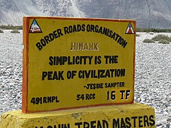
The Border Roads Organisation (BRO) is a statutory body under the ownership of the Ministry of Defence of the Government of India. BRO develops and maintains road networks in India's border areas and friendly neighboring countries. This includes infrastructure operations in 19 states and three union territories and neighboring countries such as Afghanistan, Bhutan, Myanmar, Tajikistan and Sri Lanka. By 2022, BRO had constructed over 55,000 kilometres (34,000 mi) of roads, over 450 permanent bridges with a total length of over 44,000 metres (27 mi) length and 19 airfields in strategic locations. BRO is also tasked with maintaining this infrastructure including operations such as snow clearance.

Nubra, also called Dumra, is a historical region of Ladakh, India that is currently administered as a subdivision and a tehsil in the Leh district. Its inhabited areas form a tri-armed valley cut by the Nubra and Shyok rivers. Its Tibetan name Dumra means "valley of flowers". Demands have been raised and BJP has hinted at creation of Nubra as a new district. Diskit, the headquarters of Nubra, is 120 km north of Leh, the capital of Ladakh.
Khardung La or Khardung Pass is a mountain pass in the Leh district of the Indian union territory of Ladakh.
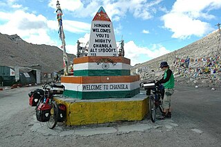
Chang La is a high mountain pass in Ladakh at an elevation of 5,391.3024 m or 17,688.000 ft in the Ladakh Range between Leh and the Shyok River valley. The Chang La, on Leh to Pangong Lake road, lies on the Leh-Karu-Sakti-Zingral-Chang La-Durbuk-Tangtse-Pangong Lake motorable road. Karu, which lies on Leh-Manali NH-3, connects Chang La and Pangong Lake to Leh and the rest of India. In September 2021, BRO opened another alternate motorable asphalt road between Zingral and Tangtse via Ke La pass and Taruk.
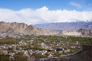
Leh district is a district in Indian-administered Ladakh in the disputed Kashmir-region. Ladakh is an Indian-administered union territory. With an area of 45,110 km2, it is the second largest district in the country, second only to Kutch. It is bounded on the north by Gilgit-Baltistan's Kharmang and Ghanche districts and Xinjiang's Kashgar Prefecture and Hotan Prefecture, to which it connects via the historic Karakoram Pass. Aksai Chin and Tibet are to the east, Kargil district to the west, and Lahul and Spiti to the south. The district headquarters is in Leh. It lies between 32 and 36 degree north latitude and 75 to 80 degree east longitude.

Roads in India are an important mode of transport in India. India has a network of over 6,331,791 kilometres (3,934,393 mi) of roads as of 31 December 2022. This is the second-largest road network in the world, after the United States. At of roads per square kilometre of land, the quantitative density of India's road network is equal to that of Hong Kong, and substantially higher than the United States, China, Brazil and Russia. Adjusted for its large population, India has approximately 5.13 kilometres (3.19 mi) of roads per 1,000 people, which is much lower than United States 20.5 kilometres (12.7 mi) but higher than that of China 3.6 kilometres (2.2 mi). India's road network carries over 71% of its freight and about 85% of passenger traffic.

Ladakh is an administrative territory of India that has been under its control since 1947. The geographical region of Ladakh union territory is the highest altitude plateau region in India, incorporating parts of the Himalayan and Karakoram mountain ranges and the upper Indus River and valley.

Shingo La is a mountain pass in India, on the state boundary between Ladakh and Himachal Pradesh. It connects the Lahaul region of Himachal Pradesh with the Zanskar region of Ladakh. A strategic road is being built on the pass to ensure an all-weather route to Ladakh, as an alternative to the Leh–Manali Highway.

Taglang La or Tanglang La, elevation 5,328 metres (17,480 ft), is a high altitude mountain pass in the Indian union territory of Ladakh. It is located on the NH3 Leh–Manali Highway. Rail-cum-road tunnels are being constructed under the Taglang La, Lungalacha La and Bara-lacha la to cater for the traffic from existing NH3 & under-construction Bhanupli–Leh line.
Marsimik La or Marsemik La, also called Lankar La, elevation 5,582 metres (18,314 ft) is a high mountain pass in the Chang Chenmo Range in the Indian union territory of Ladakh, 96 km (60 mi) east of Leh as the crow flies. Ladakh's route to the Chang Chenmo Valley traverses the pass.
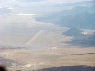
Fukche Advanced Landing Ground is an airfield in the Demchok sector of the union territory of Ladakh, India. It was built shortly before the 1962 Sino-Indian War and was revived in 2008. It is located adjacent to Koyul, 34 km northwest of Demchok.

Zoji La is a high mountain pass in the Himalayas. It is in the Kargil district, Indian Union territory of Ladakh. Located in the Dras subdivision, the pass connects the Kashmir Valley to its west with the Dras and Suru valleys to its northeast and the Indus valley further east. National Highway #1 between Srinagar and Leh in the western section of the Himalayan mountain range, traverses the pass. As of late 2022, an all-weather Zoji-la Tunnel is under construction to mitigate seasonal road blockages due to heavy snowfall.
Demchok , previously called New Demchok, and called Parigas by the Chinese, is a village and military encampment in the Indian-administered Demchok sector that is disputed between India and China. It is administered as part of the Nyoma tehsil in the Leh district of Ladakh by India, and claimed by China as part of the Tibet Autonomous Region.

The Ladakh Marathon is a marathon held in Leh, a town in the Indian Union Territory of Ladakh. It claims to be the highest marathon in the world, held at a height of 11,500 to 17,618 feet. The event's primary edition was held in 2012 and its latest edition was deferred to September 2022 due to COVID-19. In 2015 the marathon joined the Association of International Marathons and Distance Races. It is the fifth marathon from India to receive international recognition.

Pallavi Fauzdar is an Indian woman best known for her high altitude motorcycle riding and her social work. Her exploits have been recognised by a number of firsts in the Limca Book of Records.
Sasoma is a settlement in the Leh district of Ladakh in India. It is located along the Nubra River in the Nubra Valley region and consists of villages such as the Gya village. A road is being constructed from Sasoma to Saser La by the Border Roads Organisation which will be the world first glaciated motorable road once completed. Another road, the Khalsar-Sasoma road with a bridge on the Chamesahn Lungpa stream, connects Khalsar to Sasoma.
The Sasoma-Sasser La Road or Sasoma–Saser Pass Road with two extended forks - Sasoma–Sasser La-Saser Brangsa-Gapsam-Daulat Beg Oldi Road to northeast and 56-km-long Sasoma-Sasser La-Murgo Road to southeast, is a 30-ft-wide black-topped heavy-military-vehicle-grade motorable road between Nubra Valley and Depsang Plains in Ladakh in India. The route from Sasoma in west to Saser La 17,800 feet (5,400 m) & Saser Brangsa in east is 47 km long. From Saser Brangsa, the route forks into two: 9 km long Saser Brangsa to Murgo route which goes southeast of Saser Brangsa, and Saser Brangsa-Gapsam-DBO route which goes northeast of Saser Brangsa. These forks connect to the Darbuk–Shyok–DBO Road at two places: at Daulat Beg Oldi in northeast and at Murgo in southeast. This strategically important road provides a much shorter alternative access from Nubra Valley to DBO as compared to the longer 230 km route via DS-DBO Road. Saser La tunnel, 4 km section under the Saser La till Saser Brangsa, will make the route all-weather and the DPR for it was being prepared in June 2023.
The Battle of Turtuk was a military engagement between India and Pakistan that took place during the Indo-Pakistani War of 1971. Fighting between the two sides took place in Turtuk and its surrounding areas, then part of the Pakistani-administered Northern Areas in Kashmir. Following this battle, Indian forces captured Turtuk from Pakistan, which had controlled the area since the Indo-Pakistani War of 1947–1948. Per the Simla Agreement, Turtuk was incorporated into the erstwhile Indian-administered state of Jammu and Kashmir, and formally became a part of Ladakh following the revocation of Article 370 by the Government of India in August 2019.
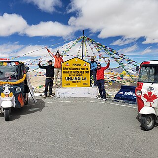
Umling La or Umlung La is a mountain pass in Ladakh, India on the ridgeline between Koyul Lungpa and the Indus River near Demchok. At an elevation of 5,640 metres (18,500 ft), it forms the source for the Umlung stream that drains into the Indus and a tributary of the Kiungdul river that drains into Koyul Lungpa.


 "Way of worship may be different but GOD is One."
 Safety sign warning against drunk driving: "AFTER WHISKY / DRIVING RISKY"
 Safety sign: "IF MARRIED, DIVORCE SPEED"


