Lahaul and Spiti district is a high-altitude district in Himachal Pradesh, north India. This entirely mountainous district consists of two geographically distinct as well as formerly separate political-administrative units, called Lahaul (Tibetan: གར་ཞ་, Wylie: gar zha) and Spiti (Tibetan: སྤི་ཏི་, Wylie: spi ti; or Tibetan: སྤྱི་ཏི, Wylie: spyi ti). Lahaul and Spiti is the largest district by area in Himachal Pradesh, and one of the least populous districts in the whole of India.[1]Kyelang (also spelled as 'Keylong') in Lahaul is the headquarters of the whole district, while Spiti also has a subdivisional headquarters, at Kaza.
Lahaul and Spiti is fast becoming a top weekend getaway destination in Himachal, due to improved road access via Atal Tunnel and rising investment in resorts and adventure activities.[2]
Geography
Physical
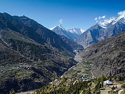
Geologically located in the Himalayas and the Tibetan Plateau, Lahaul and Spiti district is connected to Manali through the Rohtang Pass. Lahaul has three valleys, the Chandra valley (locally known as Rangloi valley), the Bhaga valley (locally known as Ghar valley), and the Chandra-Bhaga valley (locally known as Pattan valley, and further on as Chenab valley). The confluence of the Chandra and the Bhaga rivers is at Tandi. The average elevation of Spiti is significantly greater than that of Lahaul. Lahaul receives much more rainfall than Spiti.[3][4]
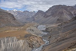
Kunzum la or the Kunzum Pass (altitude 4,551m (14,931ft)) is the entrance pass to the Spiti Valley in the east from Lahaul Valley in the west. It is 21km (13 miles) from Chandra Tal.[5] To the south, Spiti ends 24km (15 miles) from Tabo, at the Sumdo where the road enters Kinnaur and joins National Highway 5.[6] Spiti is barren and difficult to cross, with an average elevation of the valley floor of 4,270m (14,010ft). It is surrounded by lofty ranges, with the Spiti River rushing out of a gorge in the southeast to meet the Sutlej River. It is a typical mountain desert area with an average annual rainfall of only 170mm (6.7in).[7]
Lahaul and Spiti district is subdivided into two development blocks, Lahaul and Spiti.
History
Lahaul
The 'Kulu Vase', dating to the first century B.C., which was found near Gondhla monastery in the mid-19th century.
Pre-modern and early modern
Lahaul was under the influence of the kingdom of Ladakh until the early 17th century. But the rulers of Chamba and Kullu also vied for control over Lahaul in that period. In the 17th century, Lahaul came under the influence of the Rajas of Kullu, particularly under the reign of Raja Biddhi Singh (r. 1672-1688) and his successor Raja Man Singh (r. 1688-1719). In the early 19th century, Sikh forces captured Lahaul. After the Anglo-Sikh War of 1845-46, Lahaul came under the rule of the British Raj.[8][9]
Colonial period
Under British rule, Lahaul was made into a 'waziri' of the Kullu sub-division of the Kangra district of the Punjab Province. At that time, Lahaul had three 'jagir kothis' that pre-dated British rule: Kolong, Gumrang, and Gondhla. The heads of these 'kothis' (revenue districts) were hereditary 'jagirdars', and held the title of 'Thakur'.[10] The Thakur of the Kolong kothi was made the wazir for the whole of Lahaul by the British.[8]M.S. Gill remarks that the wazir was a magistrate, police officer, jailer, revenue collector, and forest officer all rolled into one.[11]
Khangsar palace, the seat of the Thakurs of Kolong.
The first Thakur of Kolong to be given the designation of the 'Wazir of Lahaul' was Thakur Hari Chand, who held this post from 1877 until his death in 1900.[10][12][13] The second Wazir of Lahaul was Thakur Amar Chand, who held this post over 1900-1921. He was the son of Thakur Hari Chand. Amar Chand was bestowed with the title of 'Rai Bahadur' by the British for his contributions to the British war effort in the First World War.[8][12][13] The third Wazir of Lahaul was Thakur Mangal Chand (1886-1969). He was the younger brother of Thakur Amar Chand. Thakur Mangal Chand was the Wazir of Lahaul from 1921 until the time Thakur Pratap Chand (his nephew and a son of Thakur Amar Chand) achieved maturity. By the 1930s, Thakur Pratap Chand had become the fourth Wazir of Lahaul, and he would be the last.[13][14]
Some sources note that the waziri was abolished in 1941. Lahaul and Spiti were then combined to form a sub-tehsil of the Kullu sub-division, and Lahaul was now administered by a Naib Tehsildar posted at Kyelang.[8][12][9] However, Gill notes that the wazir was not formally displaced; only his powers were reduced. Overall, this system involving the Naib Tehsildar and the Wazir continued till 1960, when Lahaul and Spiti were combined to create the Lahaul and Spiti district.[11]
Alongside agriculture and pastoralism, trade was an important occupation for Lahulis in the pre-Independence days. Alexander Diack noted in the late 19th century that at least one-third of the proprietors in Lahaul were engaged in trade. A major Central Asian trade route passed through Lahaul, connecting the plains of Punjab and the Kullu valley with Ladakh and Yarkand.[15] Patseo, near Darcha (the last village in northern Lahaul) used to be the site of an important annual wool mart in the colonial period. It used to witness participation from traders and herders from Lahaul, Changthang, Tibet, Zangskar, Spiti, and Kullu, alongside Khampas and Gaddis.[16] Many Lahauli would also annually go to Western Tibet to buy wool and pashmina for cash.[14]
Kardang village of Lahaul, as painted by Nicholas Roerich in 1932.
During the colonial period, Keylong had a Moravian mission, which ran from 1853 to 1940. Famous missionaries who served in Keylong included Heinrich August Jäschke, August Wilhelm Heyde, and August Hermann Francke. The Moravian missionaries did not have much success in building a Christian congregation in Lahaul. But they are remembered for introducing several crops (including potatoes, turnips, lettuce, spinach, and cauliflower), the practice of knitting, newspapers, kerosene stoves, and flue pipes to Lahaul.[17]
[For the history of Spiti, see the article on Spiti.]
Lahaul and Spiti district
In 1960, Lahaul and Spiti were carved out and combined to create a new district, Lahaul and Spiti. In 1966, this district became a part of the then emerging state of Himachal Pradesh.[8]
The harsh conditions of Lahaul permit only scattered tufts of hardy grasses and shrubs to grow, even below 4km (13,000ft). Glacier lines are usually found at 5km (16,000ft). Due to changes in climate, people in the Lahaul valley are able to grow some vegetables like cabbages, potatoes, green peas, radishes, tomatoes, carrots and leafy vegetables. The main cash crops are potatoes, cabbages, and green peas.
Some of the most common species of flora found in the Valley of Spiti include Cousinia thomsonii, Seseli trilobum, Crepis flexuosa, Caragana brevifolia and Krascheninnikovia ceratoides. There are over 62 species of medicinal plants found there as well. Several species of juniper grow in the valley, noted for their adaptation to the cold desert climate conditions. They are used by local people for religious purposes and for subsistence. The juniper forests are threatened by overuse and habitat degradation.[23] The valley is inhabited by snow leopards,[24]foxes, ibex, Himalayan brown bear, musk deer, and Himalayan blue sheep. Snow leopards are protected within the Pin Valley National Park and Kibber Wildlife Sanctuary. The Lingti plains are home to animals such as yaks and dzos.
Over-hunting and a decrease in food supplies have led to a large reduction in the population of the Tibetan antelope, argali, kiangs, musk deer, and snow leopards in these regions, reducing them to the status of endangered species. The locals of Spiti do not hunt these wild animals due to their religious beliefs.
Kibber Wildlife Sanctuary
Kibber Wildlife Sanctuary[25] is the largest wildlife sanctuary in Himachal Pradesh. It is situated at an altitude of 3600m to 6700m,[26] on the left bank of the Spiti River in the district of Lahaul and Spiti. It is sprawled over an area of 2220.12sq km. This cold desert area sanctuary was declared a wildlife sanctuary in 1992. The fauna of Kibber Wildlife Sanctuary includes ibex, snow leopard, blue sheep, and birds such as snow cock, griffons, and bearded eagle. The flora consists of Monkshood, Somlata, Pink Arnebia, Orchid, and Gentian.
According to the 2011 census, the Lahaul and Spiti district has a population of 31,564. This gives it a ranking of 638th in India (out of a total of 640).[27] The district has a population density of 2 inhabitants per square kilometre (5.2/sqmi).[27] Its population growth rate over the decade 2001-2011 was -5%.[27] Lahul and Spiti has a sex ratio of 903 females for every 1000 males, and a literacy rate of 76.81%. The entire population is rural. Scheduled Castes and Scheduled Tribes make up 7.08% and 81.44% of the population respectively.[27]
The language, culture, and populations of Lahaul and Spiti are closely related. Generally, the Lahaulis are of Tibetan and Indo-Aryan descent, while the Spiti Bhot is closer to the Tibetans, owing to their proximity to Tibet. The district has a Himachal Pradesh state legislative law in place to curb antique looting by travelers, given past incidents. In the pre-independence era, the ethnic tribal belt was divided into the British Lahaul and the Chamba Lahaul, which was merged with Punjab post-1947. This is the second-largest district in the Indian union.
The language spoken by both the Lahauli and Spiti Bhots is Bhoti, a Tibetic language of the Western Innovative subgroup. They are very similar to the Ladakh and Tibetans culturally, as they had been placed under the rule of the Guge and Ladakh kingdoms at occasional intervals.
Among the Lahaulis, the family acts as the basic unit of kinship. The extended family system is common and evolved from the polyandric system of the past. The family is headed by a senior male member, known as the Yunda, while his wife, known as the Yundamo, attains authority by being the oldest member of the generation. The clan system, also known as Rhus, plays another major role in the Lahauli society.
The Spiti Bhot community has an inheritance system that is otherwise unique to the Tibetans. Upon the death of both parents, only the eldest son will inherit the family property, while the eldest daughter inherits the mother's jewelry, and the younger siblings inherit nothing. Men usually fall back on the social security system of the Trans-Himalayan Gompas.
The lifestyles of the Lahauli and Spiti Bhot are similar, owing to their proximity. Polyandry was widely practised by the Lahaulis in the past, although this practice has been dying out. The Spiti Bhot does not generally practice polyandry anymore, although it is accepted in a few isolated regions.
Divorces are accomplished by a simple ceremony performed in the presence of village elders. Divorce can be sought by either partner. The husband has to pay compensation to his ex-wife if she does not remarry. However, this is uncommon among the Lahaulis.
Agriculture is the main source of livelihood. Potato farming is common. Occupations include animal husbandry, working in government programs and services, and other businesses and crafts that include weaving. Houses are constructed in the Tibetan architectural style, as the land in Lahul and Spiti is mountainous and quite prone to earthquakes.[31]
Most of the Lahaulis follow a combination of Hinduism and Tibetan Buddhism of the Drukpa Kagyu order, while the Spiti Bhotia follow Tibetan Buddhism of the Gelugpa order. Within Lahaul, the Todh-Gahr (upper region of Lahaul towards Ladakh) region had the strongest Buddhist influence, owing to its close proximity to Spiti.
Before the spread of Tibetan Buddhism and Hinduism, the people were adherents of the religion 'Lung Pe Chhoi', an animistic religion that had some affinities with the Bön the religion of Tibet. While the religion flourished, animal and human sacrifices were regularly offered up to the 'Iha', a term that refers to evil spirits residing in the natural world, notably in the old pencil-cedar trees, rocks, and caves. Vestiges of the Lung Pe Chhoi religion can be seen in the behavior of the Lamas, who are believed to possess certain supernatural powers.
The Losar festival (also known as Halda in Lahauli) is celebrated between the months of January and February. The date of the celebration is decided by the Lamas. It has the same significance as the Diwali festival of Hinduism, but is celebrated in a Tibetan fashion.
At the start of the festival, two or three persons from every household will walk in the procession holding burning incense. The burning sticks are then piled into a bonfire. The people will then pray to Shiskar Apa, the goddess of wealth (another name Vasudhara) in the Buddhist religion.
Buddhist monasteries
Spiti is one of the important centers of Buddhism in Himachal Pradesh. It is popularly known as the 'land of lamas'. The valley is dotted by numerous Buddhist Monasteries or Gompas. These are some of the important monasteries in the Lahul and Spiti valleys.
Kye Monastery:Kye Monastery is one of the main learning centers of Buddhist studies in Spiti. The monastery is home to some 100-odd monks who receive their education here. It is the oldest and biggest monastery in Spiti. It houses rare paintings and scriptures of Buddha and other gods and goddesses. There are also rare 'Thangka' paintings and ancient musical instruments 'like trumpets, cymbals, and drums in the monastery.[citation needed]
Tabo Monastery: Perched at an altitude of 3050 meters, Tabo Monastery is often referred to as the 'Ajanta of the Himalayas'. It is located 45 km from Kaza, Himachal Pradesh, the capital of the Spiti region. This monastery garnered interest when it celebrated its thousandth year of existence in 1996. The Tabo Monastery was founded by scholar Richen Zangpo. The monastery houses more than 60 lamas and contains a collection of rare scriptures, pieces of art, and wall paintings - Thankas, and Stucco. There is a modern guest house with a dining hall and amenities.
Kardang Monastery:Kardang Monastery, is located at an elevation of 3,500 meters across the river, about 8km from Keylong. Kardang is well connected by the road via the Tandi bridge which is about 14km from Keylong. Built-in the 12th century, this monastery houses a large library of Buddhist literature including the main Kangyur and Tangyur scriptures.
Tnagyud Gompa: Built during the early decade of 14th century, Tnagyud Gompa is of historical importance and belongs to the Sa-kya-pa sect.[33]
Kungri Gompa: This is the second oldest monastery of Spiti, and is located in Pin valley.
The natural scenery and numerous Buddhist monasteries are the main tourist attractions of the region.
The dangerous weather in Lahaul and Spiti permits visitors only between the months of June to October when the roads and villages are free of snow and the high passes (Rothang La and Kunzum La) are open. It is possible to access Spiti from Kinnaur (along the Sutlej) all through the year, although the road is sometimes temporarily closed by landslides or avalanches.
Adventure tourism
To-do-Trails: The Spiti Valley is popular with trekkers due to the challenging nature of its treks. These treks take people to remote areas including rural villages and old Gompas, as well as wildlife trails. High-altitude treks allow travelers to cross passes such as Parangla Pass (connecting Ladakh with Spiti Valley), Pin Parvati Pass, Baba Pass, Hamta Pass trek, and Spiti Left Bank Trek. Popular trekking routes in the area include Kaza-Langza-Hikim-Komic-Kaza, Kaza-Ki-Kibber-Gete-Kaza, Kaza-Losar-Kunzum La, and Kaza-Tabo-Sumdo-Nako.
Skiing: Skiing is a popular activity with tourists in Spiti.
Yak Safari:Yak rides are used to see the flora and fauna of the trans-Himalayan desert.
Notable people from Lahaul and Spiti
Subedar Major & Hony Captain Bhim Chand, VrC & bar, 'Saviour of Ladakh'
Handa, O. C. (1987). Buddhist Monasteries in Himachal Pradesh. Indus Publishing Company, New Delhi. ISBN81-85182-03-5.
Hutchinson, J. & J. PH Vogel (1933). History of the Panjab Hill States, Vol. II. (1st ed) Lahore: Govt. Printing, Punjab, 1933. Reprint 2000. Department of Language and Culture, Himachal Pradesh. Chapter X Lahaul, pp.474–483; Spiti, pp.484–488.
Janet Rizvi. (1996). Ladakh: Crossroads of High Asia. Second Edition. Oxford University Press, Delhi. ISBN0-19-564546-4.
Cunningham, Alexander. (1854). LADĀK: Physical, Statistical, and Historical with Notices of the Surrounding Countries. London. Reprint: Sagar Publications (1977).
Francke, A. H. (1977). A History of Ladakh. (Originally published as, A History of Western Tibet, (1907). 1977 Edition with critical introduction and annotations by S. S. Gergan & F. M. Hassnain. Sterling Publishers, New Delhi.
Francke, A. H. (1914). Antiquities of Indian Tibet. Two Volumes. Calcutta. 1972 reprint: S. Chand, New Delhi.
Banach, Benti (2010). 'A Village Called Self-Awareness, life and times in Spiti Valley'. Vajra Publications, Kathmandu ISBN9937506441.
This page is based on this Wikipedia article Text is available under the CC BY-SA 4.0 license; additional terms may apply. Images, videos and audio are available under their respective licenses.