
Himachal Pradesh is a state in the northern part of India. Situated in the Western Himalayas, it is one of the thirteen mountain states and is characterised by an extreme landscape featuring several peaks and extensive river systems. Himachal Pradesh is the northernmost state of India and shares borders with the union territories of Jammu and Kashmir and Ladakh to the north, and the states of Punjab to the west, Haryana to the southwest, Uttarakhand to the southeast and a very narrow border with Uttar Pradesh to the south. The state also shares an international border to the east with the Tibet Autonomous Region in China. Himachal Pradesh is also known as Dev Bhoomi or Dev Bhumi, meaning 'Land of Gods' and Veer Bhoomi which means 'Land of the Brave'.

The middle kingdoms of India were the political entities in the Indian subcontinent from 230 BCE to 1206 CE. The period begins after the decline of the Maurya Empire and the corresponding rise of the Satavahana dynasty, starting with Simuka, from 230 BCE. The "middle" period lasted for almost 1436 years and ended in 1206 CE, with the rise of the Delhi Sultanate, founded in 1206, and the end of the Later Cholas.
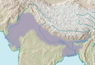
The Indo-Gangetic Plain, also known as the North Indian River Plain, is a 700-thousand km2 (172-million-acre) fertile plain encompassing northern regions of the Indian subcontinent, including most of modern-day northern and eastern India, most of eastern-Pakistan, virtually all of Bangladesh and southern plains of Nepal. Also known as the Indus–Ganga Plain, the region is named after the Indus and the Ganges rivers and encompasses a number of large urban areas. The plain is bounded on the north by the Himalayas, which feed its numerous rivers and are the source of the fertile alluvium deposited across the region by the two river systems. The southern edge of the plain is marked by the Deccan Plateau. On the west rises the Iranian Plateau. Many developed cities like Delhi, Dhaka, Kolkata, Lahore, Islamabad and Karachi are located in the Indo-Gangetic Plain.
Bilaspur is a town and a municipal council in Bilaspur district in the Indian state of Himachal Pradesh.

Bilaspur is a district of Himachal Pradesh, India. Its capital is in the town of Bilaspur. The district has an area of 1,167 km2, and a population of 381,956. As of 2011 it is the third least populous district of Himachal Pradesh, after Lahul and Spiti and Kinnaur.

Bhakra Nangal Dam is a concrete gravity dam on the Satluj River in Bhakra Village in Bilaspur district, Himachal Pradesh in northern India. The dam forms the Gobind Sagar reservoir. Nangal Dam is another dam at Nangal in Punjab downstream of Bhakra Dam. However, sometimes both the dams together are called Bhakra-Nangal Dam though they are two separate dams.

Bushahr, also spelt as 'Bashahr' and 'Bussahir' or 'Bushair' was a Rajput princely state in India during the British Raj. It was located in the hilly western Himalaya promontory bordering Tibet.

Kullu is a municipal council town that serves as the administrative headquarters of the Kullu district of the Indian state of Himachal Pradesh. It is located on the banks of the Beas River in the Kullu Valley about 10 kilometres (6.2 mi) north of the airport at Bhuntar, Kullu.
Katoch is a Chandravanshi Rajput clan. There areas of residence are mainly in the Indian states of Himachal Pradesh, Jammu, Punjab, and Uttarakhand. Traditionally resided in Kangra Fort, Trigarta Kingdom, Jalandhar, Multan.

Trigarta was an ancient Indo-Aryan kingdom based in the region of modern day Punjab. The focal point of its administration was situated in Jalandhar. However at its zenith it encompassed the hill territory extending from the Sutlej to the Ravi, with a secondary capital in Kangra. According to a genealogical record of the Kangra State, the first significant monarch is identified as Susarman, who is recognised for his participation in the Kurukshetra War based in the early Iron Age. It was during this period that the Kingdom held Multan.

The state of Himachal Pradesh is spread over an area 55,673 km2 (21,495 sq mi) and is bordered by Jammu and Kashmir and Ladakh on the north, Punjab on the southwest, Haryana on the south, Uttarakhand on the southeast, a small border with Uttar Pradesh in the south, and Tibet on the east. Entire Himachal Pradesh lies in the mountainous Himalaya region, rich in natural resources
Himachal Pradesh was established in 1948 as a Chief Commissioner's Province within the Union of India. The province comprised the hill districts around Shimla and southern hill areas of the former Punjab region. Himachal became a part C state on 1951 with the implementation of the Constitution of India. Himachal Pradesh became a Union Territory on 1 November 1956. On 18 December 1970 the State of Himachal Pradesh Act was passed by Parliament and the new state came into being on 25 January 1971. Thus Himachal emerged as the eighteenth state of the Indian Union.
Prior to the arrival of the Mughals in the Indian subcontinent, the first instance of Islamic conquest of the region was during the 10th century when Mahmud Ghaznavi conquered Kangra. After the entry of the Mughals into the subcontinent, the region fell to Mughal authority as well. Later, due to internal conflicts within the Mughal dynasty the rulers of the hill provinces took complete advantage. Kangra regained its independence under Maharaja Sansar Chand who ruled for nearly 50 years. He was one of the most powerful administrators of the region. After he took the formal possession of Kangra fort, Maharaja Sansar Chand began to expand his territory. The states of Chamba, Suket, Mandi, and, Guler, Jaswan, Siba and Datarpur came under the direct control of Maharaja Sansar Chand.

Himachal Pradesh provides water to both the Indus and Ganges basins. The drainage systems of the region are the Chenab, the Ravi, the Beas, the Satluj and the Yamuna. These rivers are perennial and are fed by snow and rainfall. They are protected by an extensive cover of natural vegetation.

Puadh is a historic region in north India that comprises parts of present-day Punjab, Haryana, Uttar Pradesh, Himachal Pradesh and the U.T. of Chandigarh, India. It has the Sutlej river in its north and covers the regions immediately south of the Ghaggar river. The people of the area are known as Puadhi and speak the Puadhi dialect of Punjabi. The capital cities of Puadh region are Rupnagar, Fatehgarh Sahib, Mohali, Patiala, Chandigarh, Nalagarh,Panchkula, Baddi ,Ambala, Yamunanagar
Ranjanka(Great King) Bhumi Chand was the founder of the Trigarta Dynasty in Satyuga. He was the first great king of the Chandravanshi group of Kshatriyas Rajputs. He is mentioned in the Puran, the holy book of Hindus, as Brahmand Puran. According to this holy book, with the blessing of Goddess Parvati, he was born in the month of April or May, the date on which 'Chetermas ki Asthami' falls.

The history of Madhya Pradesh can be divided into three periods - the ancient period, the medieval period and modern period.
Kanet is a caste found in India natively residing in the state of Himachal Pradesh. Historically, Kanets have been engaged in agriculture and allied activities. They also generally use as a Thakur title.There is a major subcaste of kanets which is known as "Mukhiya".

Mandi is a major city and a municipal corporation in Mandi District in the Indian state of Himachal Pradesh. It is situated 145 kilometres (90 mi) north of state capital, Shimla in the north-west Himalayas at an average altitude of 880 m (2,890 ft) Mandi is connected to the Pathankot through National Highway 20 and to Manali and Chandigarh through National Highway 21. Mandi is approximately 184.6 km (114.7 mi) from Chandigarh, the nearest major city, and 440.9 km (274.0 mi) from New Delhi, the national capital. In the 2011 Indian census, Mandi city had a population of 26,422. Mandi district is currently the 4th largest economy in the state. Mandi has the second highest sex ratio of 1013 females per thousand males, in the state.