Hamirpur district is in the Indian state of Himachal Pradesh. The headquarters of the district are in the town of Hamirpur. With an area of 1,118 square kilometres or 432 square miles, it is the smallest district of Himachal Pradesh.

Una district is a district in the Indian state of Himachal Pradesh. Una shares its border with the Hoshiarpur and Rupnagar districts of Punjab and Kangra, Hamirpur, and Bilaspur districts of Himachal Pradesh. The terrain is generally plain with semi hills.

Mandi district is one of the central districts of Himachal Pradesh state in northern India. The town of Mandi is the headquarters of the district.

Yamunanagar, is a city and a municipal corporation in Yamunanagar district in the Indian state of Haryana. This town is known for the cluster of plywood units and paper factories. It provides timber to larger industries. The older town is called Jagadhri. The Yamunanagar-Jagadhri railway station (YJUD) services the city. Despite its name, Jagadhri Railway is situated in Yamunanagar. There is also another railway station called Jagadhri Workshop in Yamunanagar.

Nahan is a town in Himachal Pradesh in India and is the headquarters of the Sirmaur District. It was the capital of the former Sirmur princely state. Nahan is also known as the "town of ponds".

Saharanpur district is the northernmost of the districts of Uttar Pradesh state, India. Bordering the states of Haryana, Himachal Pradesh and Uttarakhand, and close to the foothills of Shivalik range, it lies in the northern part of the Doab region.

Yamunanagar district is one of the 22 districts of the Indian state of Haryana. The district came into existence on 1 November 1989 and occupies an area of 1,756 square kilometres (678 sq mi). Yamunanagar town is the district headquarters.
Paonta Sahib is an industrial town of Himachal Pradesh in India. It is located in the south of Sirmaur district, on National Highway 72. Paonta Sahib is an important place of worship for Sikhs, hosting a large Gurdwara named Gurudwara Paonta Sahib, on the banks of the river Yamuna. The river is the boundary between the states of Himachal Pradesh and Uttarakhand.

Shimla district, known as Simla district until 1972, is one of the twelve districts of the state of Himachal Pradesh in northern India. Its headquarters is the state capital of Shimla. Neighbouring districts are Mandi and Kullu in the north, Kinnaur in the east, Uttarakhand in the southeast, Solan to the southwest and Sirmaur in the south. The elevation of the district ranges from 987 metres (3,238 ft) to 4,500 metres (14,764 ft).
Rajgarh is a town and a nagar panchayat in Sirmaur district in the Indian state of Himachal Pradesh. It was a Princely State ruled by Raja of Raghuvanshi lineage.

Renuka lake is in the Sirmaur district of Himachal Pradesh in India and it is 672 m above the sea level. It is the largest lake in Himachal Pradesh, with a circumference of about 3214 m. This lake was named after the goddess Renuka and is designated as Ramsar site since November 2005.
Shillai is a town in the Sirmaur District of Himachal Pradesh in Northern India. Shillai is located on a south east-facing hill at an elevation of 1,900 metres. The hill is called shillai dhar, and is 2,100 meters high.

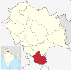
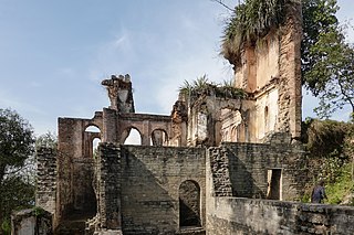
Sirmur was an independent kingdom in India, founded in 1616, located in the region that is now the Sirmaur district of Himachal Pradesh. The state was also known as Nahan, after its main city, Nahan. The state ranked predominant amongst the Punjab hill States. It had an area of 4,039 km2 and a revenue of 300,000 rupees in 1891.
Dhaulakuan or Dhaula Kuan is a small town in the Paonta Sahib tehsil of Sirmour district in the northern Indian state of Himachal Pradesh. It is strategically located between Nahan, one of the tehsils of Sirmour district, and Paonta Sahib on National Highway 72, which connects Dehradun and Shimla. It is situated on the foothills between Renuka and Dadahu, another town in Nahan tehsil.
Kamrao/kamrou/kamrau is a village in India. It is a tehsil of Sirmaur district. It is near Paonta Sahib in the Indian state of Himachal Pradesh. KAMRAU is a village in a shape of om.
Bain Kuan is a small village in Tehsil Paonta sahib, district Sirmour, Himachal Pradesh India. It is situated at Paonta-Jamniwala road which is further connected to NH-72 at Majra. This village comes under the Jamniwala Gram Panchayat. This village is about 5 km (3.1 mi) away from the Paonta sahib. The nearest villages are Jamniwala and Kishanpura. It is on the bank of the river Bata.
Simbalbara National Park is a national park in India, located in the Paonta Valley of Sirmour District, Himachal Pradesh, along its border with Haryana. It is also known as Col. Sher Jung National Park. The vegetation consists of dense Sal forests with grassy glades. The protected area was created in 1958 as the Simbalbara Wildlife Sanctuary with 19.03 km2. In 2010, 8.88 km2 were added to it and it was made into a National Park, covering an area of about 27.88 square kilometres (10.76 sq mi). There is a perennial stream in the valley. The Travel and Tourism department of Himachal Pradesh has preserved the park in its natural form.

Paonta Sahib Assembly constituency is one of the 68 constituencies in the Himachal Pradesh Legislative Assembly of Himachal Pradesh a northern state of India. Paonta Sahib is also part of Shimla Lok Sabha constituency.
Harshwardhan Chauhan is an Indian politician, who currently serves as Member of Legislative Assembly from Shillai constituency. Harshwardhan Chauhan won from Shillai constituency in 2017 state assembly elections. He is five times Member of Himachal Pradesh Legislative Assembly.