Kangra is known for having one of the oldest serving Royal Dynasty in the world, the Katoch of the Kangra State.[7] In 1758, Raja Ghamand Chand was appointed nazim or governor of Jullundur Doab under the Afghans. Ghamand Chand was a brave and strong ruler who restored the prestige of Kangra. As he was unable to capture Kangra Fort, he built another fort at Tira Sujanpur on the left bank of the Beas, almost opposite to Alampur on a hill overlooking the town. He died in 1774 and was succeeded by his son, Tegh Chand, who died too soon in 1775.[8] Ghamand Chand's grandson, Raja Sansar Chand (r.1775–1823) established the supremacy of Kangra over all the surrounding hill states. During his reign, Kangra became a major centre for the arts and several palaces were built.[9]
In 1805, the neighbouring hill states rebelled, with the aid of the Gurkha army. Raja Sansar Chand was forced to seek the help of Maharaja Ranjit Singh of the Sikh Empire. The Gurkha army was expelled but Ranjit Singh also annexed the most fertile part of the Kangra valley, reducing the Katochs of Kangra as well as the neighbouring rajas to the status of vassals.[9] Kangra was annexed by Maharaja Ranjit Singh's Sikh Empire in 1810.
Kangra became a district of British India in 1846, when it was ceded to British India at the conclusion of the First Anglo-Sikh War.[10] The British district included the present-day districts of Kangra, Hamirpur, Kullu, and Lahul and Spiti. Kangra District was part of the British province of Punjab. The administrative headquarters of the district were initially at Kangra, but were moved to Dharamshala in 1855.[11][12]
In Jainism
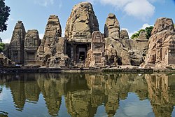
Kangra was once an important center of Jainism.[13] According to a local legend, King Suśarmācandra, after hearing the importance of Mount Shatrunjaya, took a vow to not eat or drink anything until he pays homage to Rishabhanatha at Palitana temples. Pleased by his devotion and to save him from starvation, demigoddess Ambika created a temple of Rishabhanatha at the king's fort. After paying homage to the idol, the king broke his fast.[14]
Within the premises of Kangra Fort lies an idol of Rishabhanatha. The inscription on the pedestal of the idol is in Śāradā script. It mentions that the idol was consecrated by Śvetāmbara monk Amalacandra, a disciple of Ācārya Abhaycandra of the Rājakula Gachha in 854 CE.[13] The granite idol of Rishabhanatha is seated in Padmāsana posture. An icon of bull carved on its pedestal indicates that the idol is of Rishabhanatha. However, another important trait of this idol is that it does not feature a waistband and a waistcloth, as most commonly found in Śvetāmbara icons of Tirthankaras after Bappabhattisuri's era.[15][16] Locks of hair carved on both sides of the head of the idol as well as an inscription from 854 CE, however, make it clear that the idol and the temple is of the Śvetāmbara sect of Jainism as noted by archaeologist Sir John Marshall.[13][17] Once a thriving Jaina center, it soon went unnoticed after migration of Jainas out of the town. The idol of Rishabhanatha was found in the Indreśvara Temple. Later on, efforts to reinstall the idol were made by Śvetāmbara Jaina nun Mrugavati, a disciple of Ācārya Vijayavallabhsuri. In 1978, the idol was installed in an independent shrine within Kangra Fort. Currently, the idol is under the care of the Archeological Survey of India, but Jainas are given the right to worship the idol.[14][18]
Idol of Rishabhanatha decorated with flowers and ornaments as per Śvetāmbara rituals
Dr. K. N. Sitaram, on his tour to Kangra Valley in 1930, discovered numerous remains of Jaina idols and temples. He also noted that several Jaina idols and temples were appropriated by the Hindus under different names of Hindu deities.[18]
In 1916, Muni Jinavijaya published Vijnaptitriveni, which is a detailed report about the author's pilgrimage to Nagarkot and Kangra. It explains the journey of pilgrims from Faridpur to Nagarkot. It also highlights that the pilgrims return from Nagarkot to Faridpur through another route. It also describes a war between Yasoratha, a Khokhar chief and Sikandara, a Muslim ruler.[19]
According to the 2011 census, Kangra district had a population of 1,510,075. The district has a population density of 263 inhabitants per square kilometre (680/sqmi). Its population growth rate over the decade 2001-2011 was 12.77%. 5.71% of the population lives in urban areas. Kangra district has a sex ratio of 1012 females per 1000 males and a literacy rate of 85.67%. Scheduled Castes and Scheduled Tribes made up 21.15% and 5.60% of the population respectively.[21]:18
Kangra district has the highest number of 3,869 villages among the 12 district of the state.
Kangra district stands 1st position in terms of its working force having total workers of 675,170 persons against 3,559,422 working persons of the state.
Kangra district occupies 1st rank among the districts of the state in terms of literate population. It has a literate population of 1,152,640 persons.
The economy of Kangra district is mainly depends on agriculture. It has returned 303,007 persons as cultivators and holds the 2nd position among the districts of the state
All the inhabited villages of the district enjoy the facility of electricity and potable drinking water.
Kangra district is also known for its attractive tourist destinations. Dharamsala, Kangra, Palampur, Baijnath, Jawalamukhi and Masroor are the famous places of tourist interest in the district. McLeodganj in Dharamsala is a seat of the Dalai Lama has become a place of international fame since 1966.
Central University of Himachal Pradesh at Dharamsala in Kangra district was established on 20 March 2009 under the Central University Act 2009(No.25 of 2009) of Indian Parliament.
The native people are the Kangri people and the native language is Kangri, which is very similar to Dogri. The majority of the people are Hindu, although many Tibetans and others who follow Buddhism have also settled here recently. There are also other minorities such as Sikhs, Muslims, and Christians.
Jhamakda is a folk dance of Kangra. It is exclusively performed by women. It features percussion instruments and songs.[22]
Note: British Punjab province era district borders are not an exact match in the present-day due to various bifurcations to district borders — which since created new districts — throughout the historic Punjab Province region during the post-independence era that have taken into account population increases.
Religion in the Tehsils of Kangra District (1921)[31]
Note: British Punjab province era tehsil borders are not an exact match in the present-day due to various bifurcations to tehsil borders — which since created new tehsils — throughout the historic Punjab Province region during the post-independence era that have taken into account population increases.
Religion in the Tehsils of Kangra District (1941)[33]
Note1: British Punjab province era tehsil borders are not an exact match in the present-day due to various bifurcations to tehsil borders — which since created new tehsils — throughout the historic Punjab Province region during the post-independence era that have taken into account population increases.
Note2: Tehsil religious breakdown figures for Christianity only includes local Christians, labelled as "Indian Christians" on census. Does not include Anglo-Indian Christians or British Christians, who were classified under "Other" category.
At the 2011 Census, 70.88% of the population in the district spoke Kangri, 14.92% Pahari, 5.55% Hindi, 2.64% Gaddi and 2.06% Punjabi as their first language.[34]
Dhauladhar Wildlife Sanctuary is located at an altitude of 1600 m going up to 4400 m, Dhauladhar Wildlife Sanctuary was established in 1994 by the Wildlife Department of Himachal Pradesh Government. It is situated in Kangra district. The wildlife sanctuary is covered by snow-clad mountains from three sides. The flora of Dhauladhar Wildlife Sanctuary includes deodar, rhododendron, oak, spruce, pine, and mixed conifers. This wildlife sanctuary is home to animals such as red fox, black bear, leopard sambar, Asiatic lion, angora rabbit, and deer. It covers an area of 982.86 sq.km.[35]
Pong Dam Lake Wildlife Sanctuary
Pong Dam Lake Wildlife Sanctuary covers an areas of 207.95 sq. km. in Kangra district. It is spread through the submerged area between Pong Dam Terrace (Talwara) to the bridge on Beas River at Dehra. It was created in1975, by building the highest earthfill dam in India on the Beas River in the wetland zone of the Siwalik Hills.[citation needed]
Hutchinson, J. & J. PH Vogel (1933). History of the Panjab Hill States, Vol. I. 1st edition: Govt. Printing, Punjab, Lahore, 1933. Reprint 2000. Department of Language and Culture, Himachal Pradesh. Chapter V Kangra State, pp.99–198.
This page is based on this Wikipedia article Text is available under the CC BY-SA 4.0 license; additional terms may apply. Images, videos and audio are available under their respective licenses.


