
Jabalpur, formerly Jubbulpore, is a city situated on the banks of Narmada River in the state of Madhya Pradesh, India. According to the 2011 census, it is the third-largest urban agglomeration in Madhya Pradesh and the country's 38th-largest urban agglomeration. Jabalpur is an important administrative, industrial and business center of Madhya Pradesh. It is the judicial capital of Madhya Pradesh as The Madhya Pradesh High Court along with other important administrative headquarters of India and Madhya Pradesh are located in Jabalpur. It is generally accepted that the game of snooker originated in Jabalpur. Jabalpur is the administrative headquarters of Jabalpur district and the Jabalpur division. It also is a major education centre in India. The city is known for the marble rocks on the river Narmada at Bhedaghat.

Palanpur is a city and a municipality of Banaskantha district in the Indian state of Gujarat. Palanpur is the administrative headquarters of Banaskantha district. Palanpur is the ancestral home to an industry of Indian diamond merchants.
Buldhana is a City and a Municipal Council in the Indian state of Maharashtra. Established on 17 February 1893. It is the Administrative headquarters of the Buldhana District of Amravati division. It is the Second largest City in the district after Khamgaon and a popular place as a hill station because the city is surrounded by the mountainous area in the Ajanta range. Buldhana is around 552 km away from the state capital Mumbai. Buldhana has many religious, historical and tourist places around it like Balaji Temple in rajur ghat a replica of popular Balaji Temple of South India, is a famous religious and tourist place within city limits, Shri Gajanan Maharaj Temple in Shegaon around 75 km away, the World Famous Lonar Crater a National Geo-heritage monument created by meteorite impact is almost 100 km from city of Buldhana, Rajmata Jijau birthplace Sindkhed Raja is 90 km, Sailani Baba Dargah a major attraction of Buldhana just 25 km away from the city, The World Heritage Site Ajanta Caves is just 55 km away from the City and Dnyanganga Wildlife Sanctuary in Botha Forest is also just 20 km away from the city and many more tourist places are there around Buldhana City.

Surajpur is a Nagar Palika Parishad situated in the bank of Rihand River in Surajpur district of Chhattisgarh state in Central India. It is the administrative headquarters of the Surajpur district, located 334 km away from the state's capital city, Raipur. The National Highway 43 has its route through Surajpur.

Dongargarh is a Major town of india and municipality in Rajnandgaon District in the state of Chhattisgarh, India and the site of the Bambleshwari Temple and Chandragiri Jain Temple. A prominent pilgrim destination in Rajnandgaon District, the city lies about 35 kilometres (22 mi) west from Rajnandgaon, 67 kilometres (42 mi) west from Durg and 132 kilometres (82 mi) east from Bhandara which are situated on National Highway 6. Featuring majestic mountains and ponds, Dongargarh is derived from the words: Dongarh meaning 'mountains' and garh meaning 'fort'. It is also a best tourism place in Chhattisgarh

Jhinjhak is a town and a Municipal council in Kanpur Dehat district, India. The town is situated on the Lower Ganges Canal and is approximately 20 kilometres (12 mi) from the industrial city of Dibiyapur.

Khariar is a city and a Notified Area Council in Nuapada District of the Indian state of Odisha.
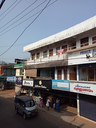
Kelakam is a small town and Grama Panchayat located in the south eastern part of Kannur district in Kerala state, India.

Dabra is a town and municipality in Gwalior district in the state of Madhya Pradesh, India located near NH-44 national highway. It serves the headquarters for both a tehsil and a coterminous community development block.
Bharunda is a village that comes under Sumerpur Tehsil in Pali district, Rajasthan. The Bharunda is an ancient village well connected to all surrounding villages and towns in the same vicinity.
Santosh Nagar Colony, or Santoshnagar Colony, is a residential and commercial area in Hyderabad, India. It is located near Saidabad in the Old City of Hyderabad and DRDO laboratories. Hyderabad International Airport is about 14 kilometres (8.7 mi) from here, spanning a 30 minute drive. It is divided into two areas, the Old Santoshnagar Colony and New Santoshnagar Colony. Santoshnagar falls under the Yakutpura assembly constituency, which is represented by All India Majlis-e-Ittehadul Muslimeen Legislator Syed Ahmed Pasha Quadri
Sabzazar is a neighbourhood and union council located in Allama Iqbal Zone of Lahore, Punjab, Pakistan. Sabzazar is divided into two subdivisions, phase 1 & phase 2.
Kotkasim is a Nagar Palika of Khairtal of the Indian state, Rajasthan.
Jawali is a town in Kangra District of Himachal Pradesh State in India.Old name of Jawali is Jawanwalashehar. Jawali is the second largest Assembly constituency in the state of Himachal Pradesh. It is located 250 km distance from its State Capital, Shimla and is located 50 km distance from its District headquarters Dharamshala.
Meghaul is a panchayat village of Khodabandpur taluk, Begusarai district, in the Indian state of Bihar.

The Bhangarh Fort is a 16th-century fort built in the Rajasthan state of India. The town was established during the rule of Bhagwant Das as the residence of his second son, Madho Singh. The fort and its precincts are well preserved.
Naranga is a developing village and gram panchayat in Parihar, Sitamarhi district, Bihar, India.
Chhapar is a small village in Jhajjar district in the state of Haryana, India. It is 32 kilometres (20 mi) from Jhajjar, which is both the District & Sub-District headquarters. It is 88 kilometres (55 mi) from New Delhi and 7 kilometres (4.3 mi) from National Highway 71 on the road from Kulana to Kosli. It had a population of 2,878 among 567 households.
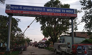
Shrikhandi Bhittha or Bhitthamore is an Indian village in the Mithila region of Bihar, situated near the Indo-Nepal border, on the banks of the perennial Ratnawati (Raato) river.
Sahayal is a rural-based town in Auraiya district in the state of Uttar Pradesh, India.
