
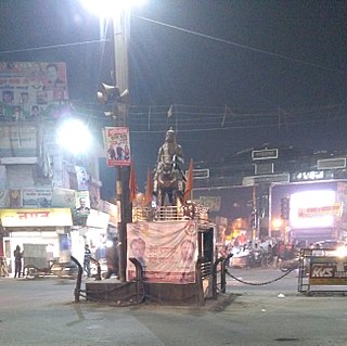
Ratlam is a city in the northwestern part of the Malwa region in Madhya Pradesh state of India. The city of Ratlam lies 480 metres (1,570 ft) above sea level. It is the administrative headquarters of Ratlam district, which was created in 1947 after the independence of India. It is located 294 kilometres west of the state capital Bhopal.

Faridabad(Hindi pronunciation:[fəɾiːdɑːbɑːd]) is the most populous city near NCT of Delhi in the Indian state of Haryana and a part of Delhi National Capital Region. It is one of the major satellite cities around Delhi and is located 284 kilometres south of the state capital, Chandigarh. The river Yamuna forms the eastern district boundary with Uttar Pradesh. The Government of India included it in the second list of Smart Cities Mission on 24 May 2016. As per the 2021 Delhi Regional Plan, Faridabad is a part of the (CNCR) Central National Capital Region or (DMA) Delhi metropolitan area.

Faridkot is a city in the South-western part of state of Punjab, India. It serves as the headquarters for both, the Faridkot district. as well as the Faridkot Division. The division was established in 1995 at Faridkot which includes Faridkot, Bathinda, and Mansa districts.
Bilaspur is a town and a municipal council in Bilaspur district in the Indian state of Himachal Pradesh.
Charkhi Dadri is a city and the headquarters of Charkhi Dadri district in the Indian state of Haryana, about 90 km from the national capital Delhi. The town was made by joining the villages of Charkhi and Dadri after urban development. Charkhi Dadri is on NH 148B between Narnaul to Bathinda and NH 348B between Meerut to Pilani segment passing through the city.
Kashipur is a city of Udham Singh Nagar district in the Indian state of Uttarakhand, and one of its seven subdivisions. Located in the western part of Udham Singh Nagar district, it is Kumaun's third most populous city and the sixth most populous in Uttarakhand. According to the 2011 Census of India, the population is 121,623 for the city of Kashipur and 283,136 for Kashipur Tehsil. Kashipur also has IIM Kashipur, one of the thirteen Indian Institutes of Managements the government has set up during the Eleventh Five-year Plan.

Badagaon Dhasan is a town and a Nagar Parishad in Tikamgarh district in the state of Madhya Pradesh, India.
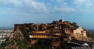
Kuchaman CityHindi pronunciation:[/ˌkuːtʃəˈmɑːnˈsɪti/] is a Municipal Council and District Headquarters of Didwana-Kuchaman District located in west-central Rajasthan, India. It is the largest city of newly Kuchaman district. The Didwana-Kuchaman district was carved out from the Nagaur District as the 38th District of the state of Rajasthan on 4 August 2023.
Raghogarh-Ruthiyai or Raghogarh-Vijaypur is a town and municipality in Guna district in the Indian state of Madhya Pradesh.

Surada is a town and a Notified Area Council in Ganjam district in the Indian state of Odisha.
Jogindernagar, or Jogindar Nagar, is a municipality, and a sub district in Mandi district in the Indian state of Himachal Pradesh. Named after Raja Joginder Sen, the hill station is the terminus of the 163-kilometre-long (101 mi) Kangra Valley narrow-gauge railway. Jogindernagar is the third-largest city in the Mandi district. The only city in Asia with three hydro-electric power stations, its nickname is "The City of Powerhouses".
The Indian Rebellion of 1857, also known as the First War of Indian Independence and the Sepoy Mutiny, was a prolonged period of armed uprisings in different parts of India, against British occupation of that part of the subcontinent.
Kanwari, also spelled Kunwari, or Kwari, is a village of 7,000 population, in Hansi-I Tehsil, Hisar-1 Rural Development Block, Hansi and Hisar of Hisar District of Hisar Division in the Haryana state of India. It is part of the saat bas bhaichara grouping of 7 villages. The village has 4 panna/patti (subdivisions), named as Nangalia Panna , upparla Panna , parla Panna , etc. with a total revenue land area of 43903 kanal or 5487 acre as per HALRIS records.

The Tekari Raj was a zamindari estate of the Bhumihar Brahmin community in South Bihar. They controlled 2,046 villages on their estate, which covered a 7,500 square kilometres (2,900 sq mi) area, near to the town of Gaya.

Latur is a city in the Indian state of Maharashtra, and is one of the largest cities of the Marathwada region. It is the administrative headquarters of Latur district and Latur Taluka. The city is a tourist hub surrounded by many historical monuments, including Udgir Fort and Kharosa Caves. The people in Latur are called Laturkar. The most spoken language in Latur is Marathi. The city's quality of education attracts students from all over Maharashtra. It is a drought prone area with acute water shortage in its city and rural areas. The economy is agriculture intensive, but in recent years is also dependent on Educational sector & its allied activities. Industrial development is minimal in the district. Latur is 43 kilometers from the epicenter of the devastating 1993 Latur earthquake.
Sarairasi is a Suburb located in Ayodhya city in the Indian state of Uttar Pradesh and is sub post office of Ayodhya.
Palam is a major residential colony located in South West Delhi. It is one of 70 Vidhan Sabha constituencies of the Delhi National Capital Territory in northern India.

Siba State, was a small independent Indian hill state in the Lower Himalayas. It was centered on the town of Dadasiba, Pragpur tehsil, Kangra district, in modern-day Himachal Pradesh. The state was founded in 1450. In 1849 the territory of Datarpur was added to Siba Jagir and annexed by the British Raj as 'Dada-Siba'.

Datarpur is a village situated in Mukerian Tehsil, Hoshiarpur District, Punjab (India). Datarpur State was a small precolonial Indian hill state in the Lower Himalayas. The state was founded around 1550 and was annexed by the Sikh Empire in 1818.
Dadwal, also written as Dadhwal and Dhadwal, is a surname prevalent in Punjab, Himachal Pradesh and Jammu. The surname is prevalent in the Rajput community. It is also prevalent in the Jatt community and is a clan name amongst Hindus and Sikhs.
