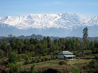
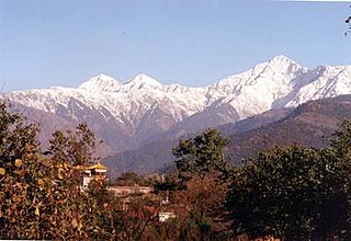
The Dhauladhar range is part of a lesser Himalayan chain of mountains. It rises from the Indian plains to the north of Kangra and Mandi. Dharamsala, the headquarters of Kangra district, lies on its southern spur in above the Kangra Valley, which divides it from Chamba.

Kangra-Lambagraon was a historical princely estate (jagir) located in the Punjab region. In 1947, the estate comprised 437 villages, encompassing an area of 324 km2. It had with a Privy Purse of Rs 70,000/- and enjoyed a revenue of approx. Rs.1,76,000/-.
Kangra is a city and a municipal council in Kangra district in the Indian state of Himachal Pradesh. Historically it was known as Nagarkot. It is the home to the Masrur Temples, also known as the Himalayan Pyramids. It has the highest number of villages among all the other districts of the state.

The Kangra Fort is located 20 kilometers from the town of Dharamsala on the outskirts of the town of Kangra, India.

Yol is a cantonment town in Kangra district in the Indian state of Himachal Pradesh.

Tiszadada is a village in Szabolcs-Szatmár-Bereg county, in the Northern Great Plain region of eastern Hungary.

Hilișeu-Horia is a commune in Botoșani County, Romania. It is composed of five villages: Corjăuți, Hilișeu-Cloșca, Hilișeu-Crișan, Hilișeu-Horia and Iezer.
Haripur is a township in Kangra district in the Indian state of Himachal Pradesh. Haripur Guler are twin townships carrying the heritage of Guler Riyasat. A river separates the two towns which further makes Pong wetland, a Ramsar Wetalnd Site, home to a large number of migratory birds in winters because of marshes and the presence of irrigated private land.
Tota Rani is a small village near Dal Lake in Kangra district, Himachal Pradesh, India. It has a very long history of settlement by Nepali people. Thapa and Gurung culture are mixed here and now the Nepali culture almost vanished and people mingle with local Himachali people, Gaddi.

Kangra Valley is situated in the Western Himalayas. Administratively, it predominantly lies in the state of Himachal Pradesh in India. It is a popular tourist destination, with the peak season around March and April. The Kangri dialect is spoken there. Dharamshala, the headquarters of Kangra district, lies on the southern spur of Dhauladhar in the valley. It is home of Masroor Rock Cut Temple, also known as "Himalayan Pyramids", a possible contender for nomination as a UNESCO World Heritage Site.

St. John in the Wilderness is a Church of North India church dedicated to John the Baptist built in 1852, located near Dharamshala, India, on the way to McLeodGanj, at Forsyth Gunj. Set amidst deodar forest, and built in neo-Gothic architecture, the church is known for its Belgian stained-glass windows donated by Lady Elgin, wife of Lord Elgin.

Dzierzbiętów Duży is a village in the administrative district of Gmina Łęczyca, within Łęczyca County, Łódź Voivodeship, in central Poland. It lies approximately 4 kilometres (2 mi) south-east of Łęczyca and 32 km (20 mi) north-west of the regional capital Łódź.

The Kangra Valley Railway lies in the sub-Himalayan region of Kangra Valley and covers a distance of 164 km (101.9 mi) from Pathankot, Punjab to Jogindernagar in Himachal Pradesh, India. The Kangra valley railway comes under the Firozpur division of Northern Railway.
Indrahar (इन्द्रहार) Pass is a mountain pass in the Dhauladhar range of the Himalayas. Located at 32°17.852′N76°22.872′E and an altitude of 4,342 metres (14,245 ft) above mean sea level, near the tourist town of Dharamshala in Himachal Pradesh, Indrahar pass forms the border between Kangra and Chamba districts. It is part of a very popular trekking route from Dharamshala. It attracts substantial tourist traffic during the trekking season between April – October.
Bhawarna is a town in Kangra district, Himachal Pradesh, India. 11 kilometres (6.8 mi) from Palampur. The postal code for Bhawarna is 176083.
Kipi, Estonia is a village in Saaremaa Parish, Saare County in western Estonia.
Diksal is a village in Parner taluka in Ahmednagar district of state of Maharashtra, India.
Jawali is a town in Kangra District of Himachal Pradesh State in India. Jawali is second largest Assembly constituency in the state of Himachal. It is located 250 km distance from its State Capital, Shimla and is located 50 km distance from its District headquarters Dharamshala.

Guler was a small precolonial Indian hill state in the Lower Himalayas. Its capital was the town of Haripur Guler, in modern-day Himachal Pradesh. The kingdom was founded in 1415 by Raja Hari Chand, a scion of the ancient royal family of Kangra.

Sulah is a village in Palampur tehsil in Kangra district of Himachal Pradesh State, India. It is located 13 kilometres (8.1 mi) from Palampur Town, 34 kilometres (21 mi) towards west from District head quarters Dharamsala. 180 kilometres (110 mi) from State capital Shimla. Sullah is famous for its natural sweet drinking water which locals claim to have medicinal properties.

