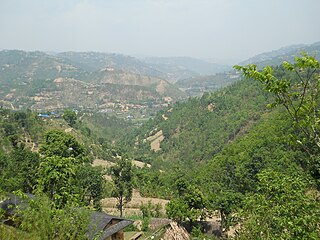
Arghakhanchi is one of the districts of Lumbini Province in Nepal. The district headquarter is Sandhikharka. The district covers an area of 1,193 km2 (461 sq mi) and has a population (2011) of 197,632. Its neighboring districts are Palpa in the east, Gulmi in the north, Kapilvastu District in the south and Pyuthan in the west.
Sarlahi, a part of Madhesh Province, is one of the seventy-seven districts of Nepal. According to new laws, a combination of more than two or four villages makes a municipality, which covers an area of 1,259 km2 (486 sq mi) and had a population of 635,701 in 2001 and 769,729 in 2011.
Wambule is a Kiranti language language spoken by the Wambule Rai, one of the Rai groups belonging to the Kiranti (किरान्ती) ethnolinguistic family of eastern Nepal. Wambule is spoken by more than 5000 people living around the confluence of the Sunkosi (सुनकोसी) and Dudhkosi (दूधकोसी) rivers near Kui-Bhir Hill. The Wambule-speaking area comprises the southernmost part of Okhaldhunga district, the westernmost part of Khotang district, the northernmost part of Udayapur district, and the northeasternmost part of Sindhuli district.

Takukot is a Ward of Barpak sulikot Rural Municipality in Gorkha District in the Gandaki Province of northern-central Nepal. At the time of the 1991 Nepal census it had a population of 4,234 and had 801 houses in the town.
Halwar is a village and former Village Development Committee that is now part of Tulsipur Sub-Metropolitan City in Dang Deokhuri District in Lumbini Province of south-western Nepal. At the time of the 1991 Nepal census it had a population of 8,182 persons living in 1339 individual households. Bat cave i.e. chamare gupha in Nepali is located here. It is surrounded by Gwar khola(rivulet) in the east and RaniGhat khola(rivulet) in west. Five rivulets flow in this VDC. Now it is merged in Tulsipur Municipality along with Tarigaun and Urahari.
Chaturale(Nepali:चतुराले) is a village in the Nuwakot District of Nepal. The Chaturale village lies in between two rivers, Dhade Khola and Sindure Khola. Chaturale is now located in Kakani Rural Municipality ward no 7. Chaturale is named after its founder, Chatur Bhuj Ale. The biggest occasion is mainly celebrated in Chaturale bazar.
Sampang language is a subgroup of Central Kiranti languages.
The Ratua Khola is a river in eastern part of Nepal. It originates from Chure Pahad of Nepal and merges with the Kankai River in Bihar, India. This river serves as the eastern border of Damak, a big and developed city in the eastern part of Nepal. This river also touches chilhara village.

Abu Simbel is a village in the Egyptian part of Nubia, about 240 km (150 mi) southwest of Aswan and near the border with Sudan. As of 2012, it has about 2600 inhabitants. It is best known as the site of the Abu Simbel temples, which were built by King Ramses II.
Khola is a small town in Bolivia.

The Trishuli River is one of the major tributaries of the Narayani River basin in central Nepal. The river is formed by the merger of Kyirong Tsangpo and Lende Khola originating in Gyirong County of Tibet, which join together near the Rasuwa Gadhi on the Nepal–Tibet border. The valley of the river provided the traditional trade route between the Kathmandu Valley and Tibet.
The Rahughat Khola is a tributary of the Kali Khola and Myagdi Khola in Nepal.

The Imja Khola is a tributary of the Dudh Kosi in Nepal. It drains the slopes of Mount Everest. The Khumbu Glacier melts into the Lobujya (Lobuche) River, which flows southward as the Imja Khola to its confluence with the Dudh Kosi at Tengboche.
Baram is a critically endangered Sino-Tibetan language spoken in Nepal. Speakers are shifting to Nepali. Dialects are Dandagaun and Mailung.

The Marshyangdi is a mountain river in Nepal. Its length is about 150 kilometres.
Chaudangsi is a Sino-Tibetan language spoken in the Indian state of Uttarakhand.
Jerung or Jero is a moribund Kiranti language spoken in Nepal. The native language consultants whom Opgenort (2005) consulted, preferred the term ‘Jero’ to designate the language. The term ‘Jerung’, by contrast, is a toponym used in the names of several villages within the language area as well as the name of a village in the Wambule-speaking area. The Jerung language is mutually intelligible with Wambule. Jerung is spoken by more than 2,000 people living in Okhalḍhuṅgā and Sindhulī districts of eastern Nepal. Gerd Hanßon (1991) claims that there are three to four dialects of Jerung: Madhavpur, Balkhu-Sisneri, and Ratnawati (Sindhuli). However, according to Opgenort's (2005) consultants, there are only two major dialects: a northern dialect, which is spoken in Okhaldhunga District (ओखलढुङ्गा), and a southern dialect, which is spoken in Sindhuli District (सिनधुली).
Tik Khola is a village in Gavkan Rural District, in the Central District of Rigan County, Kerman Province, Iran. At the 2006 census, its population was 34, in 7 families.
Simbal is a 22 different types of rajput village/hamlet in Baijnath tehsil, Kangra District of Himachal Pradesh, India. It comes under Simbal Panchayath. It is located 33 km to the east of the district headquarters Dharamshala and 141 km from the State capital Shimla.

Anuradha N. Naik is an Indian researcher working at the Central Coastal Agricultural Research Institute (CCARI) in Goa. She received the 2018 Nari Shakti Puraskar for her work supporting tribal women in cultivating Khola chilies.

