Chamba district

Last updated

Chamba district
Lakshana Devi temple (6133021771).jpg
KhajjiarDalhousie.jpg
Snowy peaks at dalhousie.jpg
View of Saach pass.jpg
Mt. Kailash Manimahesh Lake.jpg
Clockwise from top-left: Lakshana Devi Temple, Bharmour, meadow in Khajjiar, Saach pass, Manimahesh Lake, mountains near Dalhousie
Chamba in Himachal Pradesh (India).svg
Location in Himachal Pradesh
CountryFlag of India.svg  India
State Flag placeholder.svg Himachal Pradesh
Division Chamba
Headquarters Chamba
Tehsils 7
Government
   Lok Sabha constituencies 1
   Vidhan Sabha constituencies 5
Area
  Total6,522 km2 (2,518 sq mi)
Population
 (2011)
  Total519,080
  Density80/km2 (210/sq mi)
Time zone UTC+05:30 (IST)
Website http://hpchamba.nic.in/

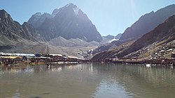
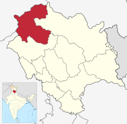
Chamba district is the northwestern district of Himachal Pradesh, in India, with its headquarters in Chamba town. The towns of Dalhousie, Khajjhiar and Churah Valley are popular hill stations and vacation spots for the people from the plains of northern India.

Contents

Economy

In 2006 the Ministry of Panchayati Raj named Chamba one of the country's 250 most backward districts (out of a total of 640). [1] It is one of the two districts in Himachal Pradesh currently receiving funds from the Backward Regions Grant Fund Programme (BRGF). [1]

Demographics

Population

Historical population
YearPop.±% p.a.
1901130,244    
1911138,943+0.65%
1921145,526+0.46%
1931150,591+0.34%
1941174,394+1.48%
1951174,537+0.01%
1961215,929+2.15%
1971251,203+1.52%
1981311,147+2.16%
1991393,286+2.37%
2001460,887+1.60%
2011519,080+1.20%
source: [2]

According to the 2011 census Chamba district has a population of 519,080, [3] roughly equal to the nation of Cape Verde. [4] This gives it a ranking of 544th in India (out of a total of 640). [3] The district has a population density of 80 inhabitants per square kilometre (210/sq mi) . [3] Its population growth rate over the decade 2001–2011 was 12.58%. [3] Chamba has a sex ratio of 989 females for every 1000 males, [3] and a literacy rate of 73.19%. 6.96% of the population lived in urban areas. Scheduled Castes and Scheduled Tribes made up 21.52% and 26.10% of the population respectively. [3] The Gaddis, the largest Scheduled Tribe in Himachal Pradesh, mainly live in Chamba district.

Religion

Religions in Chamba district (2011) [5]
ReligionPer cent
Hinduism
92.43%
Islam
7.29%
Sikhism
0.53%
Other or not stated
0.79%
Religious groups in Chamba State (British Punjab province era)
Religious
group
1901 [6] 1911 [7] [8] 1921 [9] 1931 [10] 1941 [11]
Pop. %Pop.%Pop.%Pop.%Pop.%
Hinduism Om.svg [lower-alpha 1] 119,327126,269130,489135,254155,910
Islam Star and Crescent.svg 8,3328,75010,52910,83912,318
Sikhism Khanda.svg 80141242112107
Christianity Christian cross.svg 70816394190
Buddhism Dharma Wheel (2).svg 22627541568383
Jainism Jain Prateek Chihna.svg 35330
Zoroastrianism Faravahar.svg 00000
Judaism Star of David.svg 00000
Others00000
Total population127,834135,873141,867146,870168,908
Note: British Punjab province era district borders are not an exact match in the present-day due to various bifurcations to district borders — which since created new districts — throughout the historic Punjab Province region during the post-independence era that have taken into account population increases.

Languages

Languages of Chamba district (2011) [12]

   Pahadi (24.04%)
   Chambeali (23.23%)
   Gaddi (21.80%)
   Churahi (14.40%)
   Pangwali (3.48%)
   Bhateali (2.91%)
   Hindi (2.91%)
   Gojri (1.88%)
   Kashmiri (1.31%)
   Punjabi (1.11%)
  Others (2.93%)

The majority of the people of the district are native speakers of languages in the Himachali group. These primarily include Chambeali (the first language reported by 23% of the population in the 2011 census), Gaddi or Bharmauri (22%), Churahi (14%), Pangwali (3.5%) and Bhateali (2.9%). Other languages spoken are Hindi (2.9%), Gujari (1.9%), Kashmiri (1.3%) and Punjabi (1.1%). [12] [13]

Politics

ConstituencyPartyMLARemark
No.Name
1 Churah (SC) BJP Hans Raj
2 Bharmour (ST) BJP Janak Raj
3 Chamba INC Neeraj Nayar
4 Dalhousie BJP D S Thakur
5 Bhattiyat INC Kuldeep Singh Pathania Speaker

Education

Schools

Interesting places

Laxmi Narayan Temple of Chamba Laxminarayan temple of Chamba.jpg
Laxmi Narayan Temple of Chamba

A yet another place of interest in Chamba town is the Bhuri Singh Museum at Chamba which came into existence on 14 September 1908. It is named after Raja Bhuri Singh who ruled Chamba from 1904 to 1919. Bhuri Singh donated his family collection of paintings to the museum. The embroidered Chamba-Rumals are related in style since their drawings were made by pahari painters though the embroidery was done by the household ladies.

Salooni is 56 km from Chamba.

Khajjiar is mini Switzerland in Chamba. Bhalei Mata Temple is famous in Chamba.[ citation needed ] It is 35 km from Chamba. Chhudra is 25 km from Chamba.

Villages

Fair and festivals

Chamba is famous for its vivid festivals. The Suhi Mata festival is held for four days in March/April every year in memory of princess Sui. She is known to have sacrificed her life for the cause of her people, that is, the people of Chamba.

At the time of the harvest of the maize crop, which is the main crop of this region, to express happiness and to enjoy after a hard toil, locals celebrate Minjar festival. This week long fare/ Mela is the most popular Mela of Chamba.

The temple was built by Sahil Varman in the honour of his daughter Champavati who is worshipped as a goddess in Chamba. This journey of one thousand years is a repository a civilised, cultured and developed society which existed in the lap of the Himalayas.[ citation needed ] The unique architect of houses and temples, splendid wood and metal craft, world fame Chamba Rumal and Chappal and the pahari paintings are some salient features of this one thousand years young town.[ tone ]

The Chamba town has a number of temples, Palaces and stylised buildings. Laxmi Narayana Temple, which is the main temple of Chamba town, was built by Sahil Varman in the 10th century AD. There are several other temples within the complex.

The temple of Radha Krishna, Shiva Temple of Chandergupta and Gauri Shankar Temple are among these. The ancient temple of Vajreshwari is believed to be 1000 years old and is dedicated to Devi Vajreshwari-Goddess of lightning.

The Sui Mata temple can be divided into three parts which can physically spread apart. The Hari Rai temple is dedicated to Lord Vishnu and dates back to 11th century.

Reference of Chamba town would be incomplete without the majestic Chaugan. It is the heart and hub centre of all activities in Chamba. Tradition is silent as to its use as a polo ground and the name is etymologically distinct from Chaugan, the Persian name of Polo, being of Sanskrit origin and meaning 'four-sided'. Initially the five Chaugan were a single patch of meadow.

To mark the completion of 1000 years of this town, the Government of Himachal Pradesh had celebrated the millennium of this town from 14 to 20 April 2006 in a most befitting way. The celebrations has provided the people the opportunity to have a firsthand knowledge of the rich cultural and historical past of the Chamba town.

Notable residents

Chamba district is represented in Lok Sabha by the Member of Parliament elected from Kangra (Lok Sabha constituency). Earlier it is represented for first 4 elections to Lok Sabha as member elected from Chamba (Lok Sabha constituency). The MP elected from Chamba seat were A. R Sewal in 1952, Padam Dev in 1957, Chattar Singh in 1962 and Vikram Chand Mahajan in 1967. [15]

Notes

  1. 1931-1941: Including Ad-Dharmis

Related Research Articles

<span class="mw-page-title-main">Kangra district</span> District in Himachal Pradesh, India

Kangra district is the most populous district of the Indian state of Himachal Pradesh. Dharamshala is the administrative headquarters of the district.

<span class="mw-page-title-main">Hamirpur district, Himachal Pradesh</span> A district in Himachal Pradesh, India

Hamirpur district is in the Indian state of Himachal Pradesh. The headquarters of the district are in the town of Hamirpur. With an area of 1,118 square kilometres or 432 square miles, it is the smallest district of Himachal Pradesh.

<span class="mw-page-title-main">Mandi district</span> A district in Himachal Pradesh, India

Mandi district is one of the central districts of Himachal Pradesh state in northern India. The town of Mandi is the headquarters of the district.

<span class="mw-page-title-main">Faridkot, India</span> City in Punjab, India

Faridkot is a city in the South-western part of state of Punjab, India. It serves as the headquarters for both, the Faridkot district. as well as the Faridkot Division. The division was established in 1995 at Faridkot which includes Faridkot, Bathinda, and Mansa districts.

<span class="mw-page-title-main">Jind district</span> District of Haryana in India

Jindo district is one of the 22 districts of Haryana state in northern India. Jind town is the administrative headquarters of the district. It is part of Hisar Division and was created in 1966.

<span class="mw-page-title-main">Hoshiarpur</span> City in Punjab, India

Hoshiarpur is a city and a municipal corporation in Hoshiarpur district in the Doaba region of the Indian state of Punjab. It was founded, according to tradition, during the early part of the fourteenth century. In 1809, it was occupied by the forces of Maharaja Karanvir Singh and was united into the greater state of Punjab in 1849.

<span class="mw-page-title-main">Amritsar district</span> District in Punjab, India

Amritsar district is one of the twenty three districts that make up the Indian state of Punjab. Located in the Majha region of Punjab, the city of Amritsar is the headquarters of this district.

The Hill States of India were princely states lying in the northern border regions of the British Indian Empire.

<span class="mw-page-title-main">Ambala district</span> District of Haryana in India

Ambala district is one of the 22 districts of Haryana state in the country of India with Ambala town serving as the administrative headquarters of the district. District Ambala lies on the North-Eastern edge of Haryana and borders Punjab and Himachal Pradesh. Ambala district is a part of Ambala Division.

<span class="mw-page-title-main">Firozpur district</span> District in Punjab, India

Firozpur district, also known as Ferozepur district, is one of the twenty-three districts in the state of Punjab, India. Firozpur district comprises an area of 2,190 km2 (850 sq mi).

<span class="mw-page-title-main">East Punjab</span> Former province of India from 1947 to 1950

East Punjab was a province of India from 1947 until 1950. It consisted parts of the Punjab province that remained in India following the partition of the province between the new dominions of Pakistan and the Indian Union by the Radcliffe Commission in 1947. The mostly Muslim western parts of the old Punjab became Pakistan's West Punjab, later renamed as Punjab Province, while the mostly Hindu and Sikh eastern parts remained with India.

<span class="mw-page-title-main">Jalandhar district</span> District in Punjab, India

Jalandhar district is a district in Doaba region of the state of Punjab, India. The district headquarters is the city of Jalandhar.

<span class="mw-page-title-main">Ludhiana district</span> District of Punjab in India

Ludhiana district is one of the 23 districts in the Indian state of Punjab. It is Punjab's largest district by both area and population. Ludhiana, the largest city in Punjab, is the district headquarters.

<span class="mw-page-title-main">Shimla district</span> District of Himachal Pradesh in India

Shimla district is one of the twelve districts of the state of Himachal Pradesh in northern India. Its headquarters is the state capital of Shimla. Neighbouring districts are Mandi and Kullu in the north, Kinnaur in the east, Uttarakhand in the southeast, Solan to the southwest and Sirmaur in the south. The elevation of the district ranges from 987 metres (3,238 ft) to 4,500 metres (14,764 ft).

<span class="mw-page-title-main">Chamba, Himachal Pradesh</span> Town in the Himachal Pradesh, India

Chamba is a town in the Chamba district in the Indian state of Himachal Pradesh. According to the 2001 Indian census, Chamba has a population of 20,312 people. Located at an altitude of 1,006 metres (3,301 ft) above mean sea level, the town is situated on the banks of the Ravi River, at its confluence with the Sal River.

<span class="mw-page-title-main">Sirmur State</span> Princely state of India

Sirmur was an independent kingdom in India, founded in 1616, located in the region that is now the Sirmaur district of Himachal Pradesh. The state was also known as Nahan, after its main city, Nahan. The state ranked predominant amongst the Punjab hill States. It had an area of 4,039 km2 and a revenue of 300,000 rupees in 1891.

<span class="mw-page-title-main">Religion in the Punjab</span> Cultural aspect of the region of Punjab

Religion in the Punjab in ancient history was characterized by Hinduism and later conversions to Jainism, Buddhism, Islam, Sikhism and Christianity; it also includes folk practices common to all Punjabis regardless of the religion they adhere to. Such practices incorporate local mysticism, including ancestral worship and worship of local saints of all faiths.

<span class="mw-page-title-main">Chamba State</span> One of the oldest princely states in present-day Republic of India

Chamba State was one of the oldest princely states in present-day Republic of India, having been founded during the late 6th century. It was part of the States of the Punjab Hills of the Punjab Province in India from 1859 to 1947. Its last ruler signed the instrument of accession to the Indian Union of 15 April 1948.

<span class="mw-page-title-main">Pathankot district</span> District of Punjab in India

Pathankot district is the northernmost district of the Indian state of Punjab. Pathankot is the district headquarters. The district was formed on July 27, 2011. It borders Pakistan.

<span class="mw-page-title-main">Malerkotla district</span> District in Punjab, India

Malerkotla district is a district in Punjab state of India. It was formed after the bifurcation of Sangrur district. Malerkotla district was carved out of Sangrur and became the 23rd district of Punjab on 02 June, 2021. District Malerkotla is divided into three subdivisions: Malerkotla, Amargarh and Ahmedgarh.

References

  1. 1 2 Ministry of Panchayati Raj (8 September 2009). "A Note on the Backward Regions Grant Fund Programme" (PDF). National Institute of Rural Development. Archived from the original (PDF) on 5 April 2012. Retrieved 27 September 2011.
  2. Decadal Variation In Population Since 1901
  3. 1 2 3 4 5 6 "District Census Handbook: Chamba" (PDF). censusindia.gov.in. Registrar General and Census Commissioner of India. 2011.
  4. US Directorate of Intelligence. "Country Comparison:Population". Archived from the original on 13 June 2007. Retrieved 1 October 2011. Cape Verde 516,100 July 2011 est.
  5. "Table C-01 Population by Religion: Himachal Pradesh". censusindia.gov.in. Registrar General and Census Commissioner of India. 2011.
  6. "Census of India 1901. [Vol. 17A]. Imperial tables, I-VIII, X-XV, XVII and XVIII for the Punjab, with the native states under the political control of the Punjab Government, and for the North-west Frontier Province". 1901. p. 34. JSTOR   saoa.crl.25363739 . Retrieved 30 March 2024.
  7. "Census of India 1911. Vol. 14, Punjab. Pt. 2, Tables". 1911. p. 27. JSTOR   saoa.crl.25393788 . Retrieved 30 March 2024.
  8. Kaul, Harikishan (1911). "Census Of India 1911 Punjab Vol XIV Part II". p. 27. Retrieved 30 March 2024.
  9. "Census of India 1921. Vol. 15, Punjab and Delhi. Pt. 2, Tables". 1921. p. 29. JSTOR   saoa.crl.25430165 . Retrieved 30 March 2024.
  10. "Census of India 1931. Vol. 17, Punjab. Pt. 2, Tables". 1931. p. 277. JSTOR   saoa.crl.25793242 . Retrieved 30 March 2024.
  11. India Census Commissioner (1941). "Census of India, 1941. Vol. 6, Punjab". p. 42. JSTOR   saoa.crl.28215541 . Retrieved 30 March 2024.
  12. 1 2 "Table C-16 Population by Mother Tongue: Himachal Pradesh". www.censusindia.gov.in. Registrar General and Census Commissioner of India. The census returns also include 24% who identify their language as Pahari; this can include speakers of any of the above-listed varieties of Himachali.
  13. Eberhard, David M.; Simons, Gary F.; Fennig, Charles D., eds. (2019). "India – Languages". Ethnologue (22nd ed.). SIL International.
  14. Dhiman, Vishal Kumar; Bandyopadhyay, Bosudha; Singh, Jagdeep; Kumar, Akhilesh; Chaudhary, Akshay (1 April 2022). "Himachal Pradesh's Gaddi Tribe: A Socio-Cultural Study". ECS Transactions. 107: 10061–10068. Bibcode:2022ECSTr.10710061D. doi:10.1149/10701.10061ecst . Retrieved 9 March 2024.
  15. "All Members of Lok Sabha (Since 1952) Members Biographical Sketches" . Retrieved 21 December 2017.

32°33′16″N76°07′26″E / 32.55444°N 76.12389°E / 32.55444; 76.12389