Kullu is a district in Himachal Pradesh, India. The district lies in central Himachal and is famous for its tourist stations and Himalayan Treks connecting the trails with far remote regions between the adjacent districts of Lahaul and Spiti, Kinnaur ,Shimla, Mandi and Kangra districts which are bordered at North - North East, East, south, West and South Of Kullu respectively. The District is also a home to some of the Ancient settlements, Traditional Handloom and Apple Cultivation. It stretches from the Town of Rampur in the south to the Rohtang Pass in the North. The Main Kullu Valley which falls between the Pir Panjal Himalayas and Northern Edge Of The Dhauladhar or Bhangal Region lies at an elevation ranging from as less as 833 M to 3330 M from Aut Tunnel North Portal to Atal Tunnel South Portal On NH 3 and NH 505.

Rohtang Pass is a high mountain pass on the eastern end of the Pir Panjal Range of the Himalayas around 51 km (32 mi) from Manali in the Indian state of Himachal Pradesh. It connects the Kullu Valley with the Lahaul and Spiti Valleys of Himachal Pradesh, India.

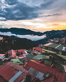
Mandi district is one of the central districts of Himachal Pradesh state in northern India. The town of Mandi is the headquarters of the district. The town has mythological and historical significance and boasts of a unique temple architecture. It is referred to as Chhoti Kashi as there are many ancient temples in the city and on the banks of river Beas.

Manali is a town in the Indian state of Himachal Pradesh. It is situated in the northern end of the Kullu Valley, formed by the Beas River. The town is located in the Kullu district, approximately 270 kilometres (170 mi) north of the state capital of Shimla and 544 kilometres (338 mi) northeast of the national capital of Delhi. With a population of 8,096 people recorded in the 2011 Indian census Manali is the beginning of an ancient trade route through Lahaul and Ladakh, over the Karakoram Pass and onto Yarkand and Hotan in the Tarim Basin of China. Manali is a popular tourist destination in India and serves as the gateway to the Lahaul and Spiti district as well as the city of Leh in Ladakh.
Parvati River is a river in the Parvati Valley in Himachal Pradesh, northern India that flows into the Beas River at Bhuntar, some 10 km south of Kullu. It rises from the Man Talai Glacier below the Pin Parbati Pass and flows in a gradual curve from north-northwest to west-southwest past the important temple town of Manikaran.

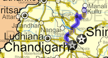
Kullu is a municipal council town that serves as the administrative headquarters of the Kullu district of the Indian state of Himachal Pradesh. It is located on the banks of the Beas River in the Kullu Valley about 10 kilometres (6.2 mi) north of the airport at Bhuntar.

The Pir Panjal Range is a group of mountains in the Lesser Himalayan region, running from east-southeast (ESE) to west-northwest (WNW) across the Indian territories of Himachal Pradesh and Jammu and Kashmir and then Pakistan's Azad Kashmir and Punjab. The average elevation varies from 1,400 m (4,600 ft) to 4,100 m (13,500 ft). The Himalayas show a gradual elevation towards the Dhauladhar and Pir Panjal ranges. Pir Panjal is the largest range of the Lesser Himalayas. Near the bank of the Sutlej River, it dissociates itself from the Himalayas and forms a divide between the Beas and Ravi rivers on one side and the Chenab on the other. The renowned Galyat mountains are also located in this range.

Situated on the left bank of river Beas at an altitude of 1,800 meters, Naggar is an ancient town in Kullu district of Himachal Pradesh, India. It was once capital of the Kullu kingdom.
Raison is a stopover which has vast camping grounds maintained by Himachal Pradesh Tourism.
The development of tribal areas in Himachal Pradesh is one of the major steps taken by the state government for its economic development. The border districts of Kinnaur, Lahaul, Spiti and the Pangi and Bharmour tehsils of Chamba districts are the major tribal areas of the state. They are located near the borders of Tibet and Indian States of Jammu and Kashmir. Other backward areas include Shillai in Sirmaur district, and deep cut-off valleys in the Kullu and upper stretches of Kangra districts. Due to poor accessibility, life in these areas had grown in isolation.

Kullu Valley is a broad open valley in Himachal Pradesh, India, formed by the Beas River between Manali and Largi. This valley is famous for its temples, beauty and its majestic hills covered with pine and deodar forest and sprawling apple orchards. The course of the Beas river presents a succession of magnificent, clad with forests of deodar, towering above trees of pine on the lower rocky ridges. Kullu valley is sandwiched between the Pir Panjal, Lower Himalayan and Great Himalayan Ranges. Ski touring is a sport growing in popularity in the Himilayan peaks surrounding the valley.

The Sar Pass is in Parvati Valley of Kullu district of Himachal Pradesh, a state of India.

The Saurkundi Pass Trek is a hiking trail in the Kullu district of Himachal Pradesh, a state of northern India. The trek is an 11-day program and participants hike every day during the period. The groups range from 40 to 50 persons. The trail starts at Babeli, the base camp, and passes through scenic spots in the Kullu valley.

Kullu–Manali Airport is an airport located in Bhuntar, Kullu in the Indian state of Himachal Pradesh. The airport is located 11 km from Kullu town and 52 km from Manali.

Mandi is a major city and a municipal corporation in Mandi District in the Indian state of Himachal Pradesh.
The Western Himalayas refers to the western half of the Himalayas, in northern Pakistan and northwestern India. It is also known as the Punjab Himalayas. Four of the five tributaries of the Indus River in Punjab rise in the Western Himalayas; while the fifth, the Sutlej cuts through the range after rising in Tibet.

National Highway 3, or NH 3, is a national highway in India. It starts from Atari adjacent to India-Pakistan border and near Amritsar and terminates at Leh in Ladakh, via Manali in Himachal Pradesh.
Tourism in Himachal Pradesh relates to tourism in the Indian state of Himachal Pradesh. This is popularly renowned for its Himalayan landscapes and popular hill-stations. Many outdoor activities such as rock climbing, mountain biking, paragliding, ice-skating, trekking, rafting, and heli-skiing are popular tourist attractions in Himachal Pradesh.
Chanderkhani Pass is a pass located in the Kullu District of India at a height of 3,660 metres. It forms a way (pass) between the villages of Rumsu and Pulag to the well known village of Malana, which indirectly forms a trekking route from Naggar to Malana across the Chanderkhani Pass.

Mud is a small village in the cold desert region of Spiti in Himachal Pradesh, India. Located at an altitude of 3,810 m (12,500 ft) on the left bank of the Pin River, a right bank tributary of the Spiti River, the village nestles at the base of the Parbati range that towers almost vertically 1,600 m (5,200 ft) above. Mud is near the boundary of the Pin Valley National Park and is a convenient base for treks in the park, and to the neighbouring districts of Kullu and Kinnaur. It is the last village on the Spiti side of the Pin Parbati trek to Kullu and the Pin Bhaba trek to Kinnaur.