Himachal Pradesh is a state in the northern part of India. Situated in the Western Himalayas, it is one of the thirteen mountain states and is characterised by an extreme landscape featuring several peaks and extensive river systems. Himachal Pradesh is the northernmost state of India and shares borders with the union territories of Jammu and Kashmir and Ladakh to the north, and the states of Punjab to the west, Haryana to the southwest, Uttarakhand to the southeast and a very narrow border with Uttar Pradesh to the south. The state also shares an international border to the east with the Tibet Autonomous Region in China. Himachal Pradesh is also known as Dev Bhoomi or Dev Bhumi, meaning 'Land of Gods' and Veer Bhoomi which means 'Land of the Brave'.

Valley of Flowers National Park is an Indian national park which was established in 1982. It is located in Chamoli in the state of Uttarakhand and is known for its meadows of endemic alpine flowers and the variety of flora. This richly diverse area is also home to rare and endangered animals, including the Asiatic black bear, snow leopard, musk deer, brown bear, red fox and blue sheep. Birds found in the park include Himalayan monal pheasant and other high-altitude birds.

The Lahaul and Spiti district in the Indian state of Himachal Pradesh consists of the two formerly separate districts of Lahaul and Spiti. The present administrative center is Kyelang in Lahaul. Before the two districts were merged, Kardang was the capital of Lahaul, and Dhankar the capital of Spiti. The district was formed in 1960 and is the fourth least populous district in India. It is the least densely populated district of India, according to the Census of India 2011.

Saussurea is a genus of about 300 species of flowering plants in the tribe Cardueae within the family Asteraceae, native to cool temperate and arctic regions of East Asia, Europe, and North America, with the highest diversity in alpine habitats in the Himalayas and East Asia. Common names include saw-wort and snow lotus, the latter used for a number of high altitude species in East Asia.

Hemis National Park is a high-elevation national park in Hemis in Leh district of Ladakh, India. It approx. 50 km from Leh, the capital of Ladakh. Globally famous for its snow leopards, it is believed to have the highest density of them in any protected area in the world. It is the only national park in India that is north of the Himalayas, the largest notified protected area in India and is the second largest contiguous protected area, after the Nanda Devi Biosphere Reserve and surrounding protected areas. The park is home to a number of species of endangered mammals, including the snow leopard. Hemis National Park is India's protected area inside the Palearctic realm, outside the Changthang Wildlife Sanctuary northeast of Hemis, and the proposed Tso Lhamo Cold Desert Conservation Area in North Sikkim.

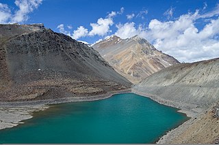
Chandra Taal is a lake in the upper Chandra valley of the Lahul and Spiti district of Himachal Pradesh, India. Chandra Taal is near the source of the Chandra River. Despite the rugged and inhospitable surroundings, it is in a protected niche with some flowers and wildlife in summer. It is a favourite spot for tourists and high-altitude trekkers. It is usually associated with Spiti, although geographically it lies in the watershed of the Chandra River of Lahaul. Kunzum La separates Lahaul and Spiti valleys.

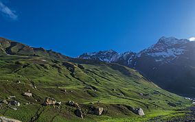
Spiti is a high-altitude region of the Himalayas, located in the north-eastern part of the northern Indian state of Himachal Pradesh. The name "Spiti" means "The middle land", i.e. the land between Tibet and India. Spiti incorporates mainly the valley of the Spiti River, and the valleys of several rivers that feed into the Spiti River. Some of the prominent side-valleys in Spiti are the Pin valley and the Lingti valley. Spiti is bordered on the east by Tibet, on the north by Ladakh, on the west and southwest by Lahaul, on the south by Kullu, and on the southeast by Kinnaur. Spiti has a cold desert environment. The valley and its surrounding regions are among the least populated regions of India. The Bhoti-speaking local population follows Tibetan Buddhism.
Suraj Tal, also called Tso Kamtsi or Surya Tal, is an 800 m (2,600 ft) long lake that lies just below the 4,890 m (16,040 ft) high Bara-lacha-la pass in Lahaul and Spiti district of the Indian state of Himachal Pradesh. It is the third-highest lake in India and the 21st-highest in the world. Suraj Tal Lake is just below the source of the Bhaga River that joins the Chandra River downstream at Tandi to form the Chandrabhaga River in Himachal Pradesh. The Chandrabhaga River is known as the Chenab as it enters the Jammu region of Jammu and Kashmir. The other major tributary of the Chandrabhaga, the Chandra, originates and flows south-east of the Bara-lacha La.
The Karakoram Wildlife Sanctuary, also known as the Karakoram Wildlife Sanctuary or the Karakoram Wildlife Sanctuary is a high altitude wildlife sanctuary located in the easternmost reaches of the Karakoram range in Leh district, in the Indian union territory of Ladakh. It was established in 1987 and covers an area of about 5,000 square kilometres (500,000 ha). It is an important wildlife sanctuary due to being one of the few places in India with a migratory population of the Chiru or Tibetan Antelope.
The Trans himalaya, or "Gangdise – Nyenchen Tanglha range", is a 1,600-kilometre-long (990 mi) mountain range in China, India and Nepal, extending in a west–east direction parallel to the main Himalayan range. Located north of Yarlung Tsangpo river on the southern edge of the Tibetan Plateau, the Transhimalaya is composed of the Gangdise range to the west and the Nyenchen Tanglha range to the east.
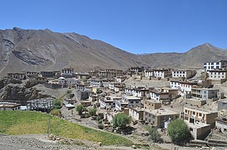
Kibber, also Kibber Khas and Khyipur, is a village high in the Spiti Valley in the Himalayas at 4,270 m (14,010 ft) in Himachal Pradesh in northern India. It contains a monastery and is a base for visiting the Kibber Wildlife Sanctuary. It is located 19 km (12 mi) from Kaza and a bus service connects them in the summer months. Agriculture forms the backbone of the local economy and lush green fields are abundant. It is the base for visitors to the Kibber Wildlife Sanctuary, home to about 30 snow leopards. Treks to nearby peaks and to a high pass in the Zanskar range between Spiti and Ladakh start from Kibber.

Buddhism in the Himachal Pradesh state of India of has been a long-recorded practice. The spread of Buddhism in the region has occurred intermediately throughout its history. Starting in the 3rd century BCE, Buddhism was propagated by the Maurya Empire under the reign of Ashoka. The region would remain an important center for Buddhism under the Kushan Empire and its vassals. Over the centuries the following of Buddhism has greatly fluctuated. Yet by experiencing revivals and migrations, Buddhism continued to be rooted in the region, particularly in the Lahaul, Spiti and Kinnaur valleys.

Cold Desert Biosphere Reserve is a biosphere reserve located in the Western Himalayas, within Himachal Pradesh in North India. It was established as a biosphere reserve in August 2009. Biosphere reserves are the areas of terrestrial and coastal ecosystems which promote the conservation of biodiversity with its sustainable use. There are over 738 biosphere reserves around the world in over 134 countries. The ministry of environment and forest provides financial assistance to the respective state governments for conservation of landscape, biological diversity and the cultural heritage. This region has the status of a Cold Desert biome. This region carries the status of a Cold Desert biome for two reasons, one is the leeward part of the Himalayas which is spared from monsoon winds and the other is its position at high altitude, on average 3000–5000 metres.

Chandra Prakash Kala is an Indian ecologist and professor. His research interests include alpine ecology, conservation biology, indigenous knowledge systems, ethnobotany and medicinal aromatic plants. He is an assistant professor in the faculty area of Ecosystem and Environment Management at the Indian Institute of Forest Management.

Koksar is one of the villages in Lahaul Mandal in Lahaulspiti District in Himachal Pradesh state in Northern India. Koksar meaning is Alpine, Big, Colossal, Gigantic, Highland, Huge, Mammoth, Tall and Towering. Koksar is about 19 km from Rohtang Pass, and 7 km from North Portal of Atal Tunnel Rohtang. Koksar is the coldest place in Lahaul. It is mostly snowed-in during winters but during the summer months, the PWD Rest House and Eating places are in business. It is a mountainous area from which views and pathways for hiking can be seen. It is 340 km from its state capital Shimla and 70 km from Manali.

National Highway 505, commonly called NH 505, is a national highway in India. It is a spur road of National Highway 5. NH 505 traverses the state of Himachal Pradesh in India. NH 505 is a high elevation road, covering the Kinnaur and Lahaul and Spiti districts of Himachal Pradesh, mainly running along the Spiti River in the Spiti Valley. The highway from Kaza to Gramphu remains closed for 6–9 months in a year due to heavy snowfall and the closure of Kunzum La pass at an elevation of 4,550 m (14,930 ft).

Mud is a small village in the cold desert region of Spiti in Himachal Pradesh, India. Located at an altitude of 3,810 m (12,500 ft) on the left bank of the Pin River, a right bank tributary of the Spiti River, the village is nestled at the base of the Parbati range that towers almost vertically 1,600 m (5,200 ft) above. Mud is near the boundary of the Pin Valley National Park and is a convenient base for treks in the park, and to the neighbouring districts of Kullu and Kinnaur. It is the last village on the Spiti side of the Pin Parbati trek to Kullu and the Pin Bhaba trek to Kinnaur.
Lata Thakur was an Indian politician. She was an MLA from the Lahaul and Spiti Assembly Constituency in the 1972 Himachal Pradesh Legislative Assembly. She belonged to the Indian National Congress. Lata Thakur was the first female legislator from Lahaul and Spiti, and the first Scheduled Tribe MLA in all of Himachal Pradesh.
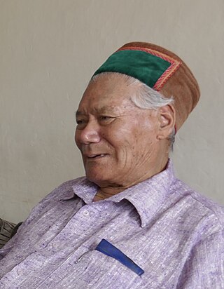
Tobdan is a historian and linguist from Himachal Pradesh, India. He is noted for his work on the cultural traditions, histories, and languages of the Lahaul and Spiti district, and some neighboring regions.
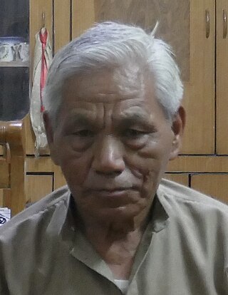
Tshering Dorje was a cultural historian from Himachal Pradesh, India. He was regarded as an authority on the cultural traditions and histories of the Lahaul and Spiti district and some neighboring regions. He also played an important role in bringing about the construction of the 9.02 km-long, high-altitude Atal Tunnel.